|
|
|||||||||||||||||
| Point ID: 8355 | Downloads | Plots | Site Data | Code: 9332 |
|
|
|||||||||||||||||
| Download | |
|---|---|
| Site Descriptor Information | Site Time Series Data |
| Link to all available data | |
|
|
| View: | Statistics | Time Series |
| Units: | mm |
| Statistic | Jan | Feb | Mar | Apr | May | Jun | Jul | Aug | Sep | Oct | Nov | Dec | Annual |
|---|---|---|---|---|---|---|---|---|---|---|---|---|---|
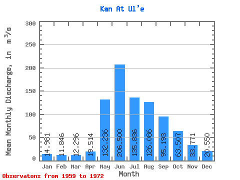
| Mean | 14.98 | 11.85 | 12.30 | 19.51 | 132.24 | 206.50 | 135.84 | 126.09 | 95.19 | 63.51 | 33.77 | 20.55 | 72.69 |
| Standard Deviation | 4.63 | 3.46 | 1.94 | 4.93 | 42.98 | 77.42 | 35.53 | 43.58 | 23.46 | 16.78 | 5.94 | 5.09 | 13.44 |
| Min | 8.61 | 7.27 | 9.55 | 12.20 | 67.30 | 129.00 | 72.80 | 71.10 | 62.80 | 42.00 | 24.00 | 13.60 | 52.51 |
| Max | 23.70 | 19.00 | 15.80 | 29.80 | 221.00 | 388.00 | 193.00 | 235.00 | 135.00 | 103.00 | 42.70 | 32.50 | 104.85 |
| Coefficient of Variation | 0.31 | 0.29 | 0.16 | 0.25 | 0.33 | 0.38 | 0.26 | 0.35 | 0.25 | 0.26 | 0.18 | 0.25 | 0.18 |
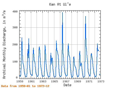
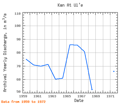
| Year | Jan | Feb | Mar | Apr | May | Jun | Jul | Aug | Sep | Oct | Nov | Dec | Annual | 1959 | 18.00 | 14.40 | 12.80 | 24.60 | 142.00 | 240.00 | 150.00 | 93.00 | 81.10 | 65.90 | 34.70 | 23.30 | 74.98 | 1960 | 15.70 | 10.30 | 10.20 | 12.20 | 74.10 | 171.00 | 121.00 | 235.00 | 84.60 | 56.90 | 34.30 | 23.70 | 70.75 | 1961 | 23.60 | 19.00 | 15.80 | 22.20 | 132.00 | 180.00 | 133.00 | 99.20 | 97.90 | 59.00 | 32.30 | 23.90 | 69.83 | 1962 | 15.20 | 12.40 | 13.10 | 22.30 | 166.00 | 187.00 | 162.00 | 107.00 | 72.50 | 54.30 | 28.20 | 13.60 | 71.13 | 1963 | 16.30 | 13.40 | 13.20 | 15.20 | 67.30 | 197.00 | 163.00 | 92.50 | 62.80 | 42.00 | 24.00 | 15.80 | 60.21 | 1964 | 11.10 | 8.73 | 10.80 | 13.30 | 101.00 | 150.00 | 83.20 | 119.00 | 121.00 | 60.00 | 37.10 | 15.20 | 60.87 | 1965 | 10.20 | 9.27 | 9.55 | 16.10 | 221.00 | 165.00 | 164.00 | 145.00 | 135.00 | 95.70 | 41.60 | 16.40 | 85.73 | 1966 | 15.10 | 11.80 | 12.70 | 18.20 | 91.90 | 388.00 | 149.00 | 138.00 | 91.40 | 53.90 | 32.00 | 24.60 | 85.55 | 1967 | 16.10 | 15.20 | 14.90 | 23.00 | 166.00 | 205.00 | 141.00 | 132.00 | 121.00 | 72.10 | 42.70 | 17.70 | 80.56 | 1968 | 8.61 | 7.38 | 10.80 | 19.20 | 124.00 | 129.00 | 82.70 | 71.10 | 66.10 | 60.10 | 31.00 | 20.10 | 52.51 | 1969 | 13.90 | 10.70 | 14.10 | 21.90 | 144.00 | 161.00 | 72.80 | 80.40 | 93.10 | 61.70 | 36.60 | 16.60 | 60.57 | 1970 | 9.32 | 7.27 | 10.10 | 14.40 | 182.00 | 365.00 | 193.00 | 172.00 | 127.00 | 103.00 | 42.60 | 32.50 | 104.85 | 1971 | 23.70 | 16.20 | 13.40 | 29.80 | 137.00 | 149.00 | 126.00 | 115.00 | 75.20 | 53.00 | 30.10 | 23.30 | 65.97 | 1972 | 12.90 | 9.80 | 10.70 | 20.80 | 103.00 | 204.00 | 161.00 | 166.00 | 104.00 | 51.50 | 25.60 | 21.00 | 74.19 |
|---|
 Return to R-Arctic Net Home Page