|
|
|||||||||||||||||
| Point ID: 8300 | Downloads | Plots | Site Data | Code: 9174 |
|
|
|||||||||||||||||
| Download | |
|---|---|
| Site Descriptor Information | Site Time Series Data |
| Link to all available data | |
|
|
| View: | Statistics | Time Series |
| Units: | mm |
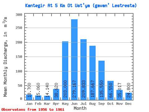
| Statistic | Jan | Feb | Mar | Apr | May | Jun | Jul | Aug | Sep | Oct | Nov | Dec | Annual |
|---|---|---|---|---|---|---|---|---|---|---|---|---|---|
| Mean | 18.70 | 15.06 | 14.14 | 38.62 | 203.00 | 279.17 | 209.83 | 187.67 | 135.55 | 66.55 | 35.02 | 24.80 | 107.08 |
| Standard Deviation | 3.39 | 1.49 | 2.48 | 31.93 | 49.09 | 83.05 | 77.65 | 49.49 | 32.73 | 11.31 | 10.17 | 5.96 | 18.41 |
| Min | 15.50 | 12.90 | 10.50 | 15.40 | 123.00 | 183.00 | 122.00 | 104.00 | 95.30 | 53.70 | 23.30 | 17.10 | 91.78 |
| Max | 23.70 | 16.90 | 17.30 | 94.80 | 256.00 | 390.00 | 294.00 | 249.00 | 178.00 | 86.40 | 48.60 | 33.10 | 136.93 |
| Coefficient of Variation | 0.18 | 0.10 | 0.17 | 0.83 | 0.24 | 0.30 | 0.37 | 0.26 | 0.24 | 0.17 | 0.29 | 0.24 | 0.17 |
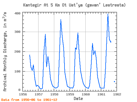
| Year | Jan | Feb | Mar | Apr | May | Jun | Jul | Aug | Sep | Oct | Nov | Dec | Annual | 1956 | 183.00 | 122.00 | 104.00 | 132.00 | 60.70 | 23.30 | 29.60 | 1957 | 23.70 | 12.90 | 10.50 | 15.40 | 201.00 | 287.00 | 122.00 | 175.00 | 136.00 | 61.10 | 34.60 | 22.20 | 91.78 | 1958 | 19.00 | 14.80 | 17.30 | 24.00 | 216.00 | 362.00 | 275.00 | 218.00 | 95.30 | 53.70 | 23.30 | 20.60 | 111.58 | 1959 | 15.60 | 16.90 | 14.60 | 29.00 | 219.00 | 211.00 | 294.00 | 176.00 | 105.00 | 66.80 | 41.80 | 26.20 | 101.33 | 1960 | 19.70 | 15.90 | 13.40 | 29.90 | 123.00 | 242.00 | 184.00 | 204.00 | 167.00 | 70.60 | 38.50 | 17.10 | 93.76 | 1961 | 15.50 | 14.80 | 14.90 | 94.80 | 256.00 | 390.00 | 262.00 | 249.00 | 178.00 | 86.40 | 48.60 | 33.10 | 136.93 |
|---|
 Return to R-Arctic Net Home Page