|
|
|||||||||||||||||
| Point ID: 8296 | Downloads | Plots | Site Data | Code: 9149 |
|
|
|||||||||||||||||
| Download | |
|---|---|
| Site Descriptor Information | Site Time Series Data |
| Link to all available data | |
|
|
| View: | Statistics | Time Series |
| Units: | mm |
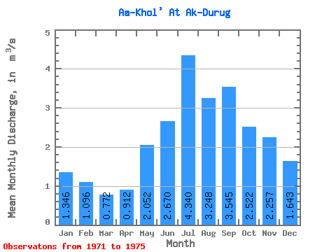
| Statistic | Jan | Feb | Mar | Apr | May | Jun | Jul | Aug | Sep | Oct | Nov | Dec | Annual |
|---|---|---|---|---|---|---|---|---|---|---|---|---|---|
| Mean | 1.35 | 1.10 | 0.77 | 0.91 | 2.05 | 2.67 | 4.34 | 3.25 | 3.54 | 2.52 | 2.26 | 1.64 | 2.19 |
| Standard Deviation | 0.19 | 0.29 | 0.31 | 0.14 | 0.62 | 1.09 | 4.14 | 1.10 | 1.44 | 0.77 | 0.45 | 0.42 | 0.65 |
| Min | 1.14 | 0.68 | 0.43 | 0.76 | 1.41 | 1.64 | 1.83 | 2.26 | 1.92 | 1.70 | 1.64 | 1.25 | 1.71 |
| Max | 1.61 | 1.42 | 1.18 | 1.05 | 2.77 | 3.65 | 10.50 | 4.31 | 5.08 | 3.43 | 2.59 | 2.05 | 3.10 |
| Coefficient of Variation | 0.14 | 0.27 | 0.41 | 0.15 | 0.30 | 0.41 | 0.95 | 0.34 | 0.41 | 0.30 | 0.20 | 0.25 | 0.30 |
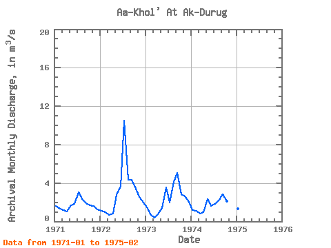
| Year | Jan | Feb | Mar | Apr | May | Jun | Jul | Aug | Sep | Oct | Nov | Dec | Annual | 1971 | 1.61 | 1.33 | 1.18 | 1.05 | 1.67 | 1.81 | 3.06 | 2.33 | 1.92 | 1.70 | 1.64 | 1.25 | 1.71 | 1972 | 1.14 | 0.97 | 0.67 | 0.84 | 2.77 | 3.65 | 10.50 | 4.31 | 4.37 | 3.43 | 2.58 | 1.95 | 3.10 | 1973 | 1.45 | 0.68 | 0.43 | 0.76 | 1.41 | 3.58 | 1.97 | 4.09 | 5.08 | 2.84 | 2.59 | 2.05 | 2.24 | 1974 | 1.20 | 1.08 | 0.81 | 1.00 | 2.36 | 1.64 | 1.83 | 2.26 | 2.81 | 2.12 | 2.22 | 1.32 | 1.72 | 1975 | 1.33 | 1.42 |
|---|
 Return to R-Arctic Net Home Page