|
|
|||||||||||||||||
| Point ID: 8288 | Downloads | Plots | Site Data | Code: 9123 |
|
|
|||||||||||||||||
| Download | |
|---|---|
| Site Descriptor Information | Site Time Series Data |
| Link to all available data | |
|
|
| View: | Statistics | Time Series |
| Units: | mm |
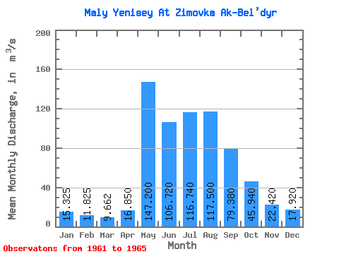
| Statistic | Jan | Feb | Mar | Apr | May | Jun | Jul | Aug | Sep | Oct | Nov | Dec | Annual |
|---|---|---|---|---|---|---|---|---|---|---|---|---|---|
| Mean | 15.32 | 11.82 | 9.66 | 16.85 | 147.20 | 106.72 | 116.74 | 117.50 | 79.38 | 45.94 | 22.42 | 17.92 | 57.93 |
| Standard Deviation | 1.44 | 1.28 | 0.61 | 4.67 | 44.52 | 35.83 | 33.20 | 41.99 | 8.44 | 6.72 | 2.55 | 3.85 | 8.61 |
| Min | 13.70 | 10.80 | 8.99 | 12.00 | 92.00 | 55.60 | 68.20 | 60.50 | 71.10 | 37.40 | 18.40 | 11.70 | 50.70 |
| Max | 17.10 | 13.70 | 10.40 | 21.10 | 209.00 | 146.00 | 151.00 | 161.00 | 93.20 | 55.70 | 25.50 | 21.90 | 68.04 |
| Coefficient of Variation | 0.09 | 0.11 | 0.06 | 0.28 | 0.30 | 0.34 | 0.28 | 0.36 | 0.11 | 0.15 | 0.11 | 0.21 | 0.15 |
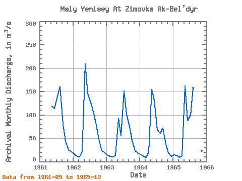
| Year | Jan | Feb | Mar | Apr | May | Jun | Jul | Aug | Sep | Oct | Nov | Dec | Annual | 1961 | 119.00 | 113.00 | 139.00 | 161.00 | 80.10 | 43.80 | 25.50 | 21.90 | 1962 | 17.10 | 11.50 | 9.89 | 21.10 | 209.00 | 146.00 | 126.00 | 107.00 | 77.90 | 48.30 | 22.70 | 20.00 | 68.04 | 1963 | 13.70 | 11.30 | 10.40 | 13.70 | 92.00 | 55.60 | 151.00 | 102.00 | 74.60 | 44.50 | 22.80 | 18.40 | 50.83 | 1964 | 15.70 | 10.80 | 8.99 | 20.60 | 154.00 | 131.00 | 68.20 | 60.50 | 71.10 | 37.40 | 18.40 | 11.70 | 50.70 | 1965 | 14.80 | 13.70 | 9.37 | 12.00 | 162.00 | 88.00 | 99.50 | 157.00 | 93.20 | 55.70 | 22.70 | 17.60 | 62.13 |
|---|
 Return to R-Arctic Net Home Page