|
|
|||||||||||||||||
| Point ID: 8277 | Downloads | Plots | Site Data | Code: 8403 |
|
|
|||||||||||||||||
| Download | |
|---|---|
| Site Descriptor Information | Site Time Series Data |
| Link to all available data | |
|
|
| View: | Statistics | Time Series |
| Units: | mm |
| Statistic | Jan | Feb | Mar | Apr | May | Jun | Jul | Aug | Sep | Oct | Nov | Dec | Annual |
|---|---|---|---|---|---|---|---|---|---|---|---|---|---|
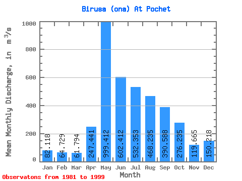
| Mean | 82.12 | 64.73 | 61.79 | 247.44 | 999.41 | 602.41 | 532.35 | 468.24 | 390.59 | 276.24 | 119.67 | 150.22 | 332.93 |
| Standard Deviation | 15.42 | 13.26 | 9.17 | 179.33 | 440.51 | 186.10 | 254.68 | 231.60 | 135.50 | 74.14 | 25.87 | 199.80 | 82.75 |
| Min | 51.10 | 39.90 | 43.10 | 78.60 | 363.00 | 289.00 | 213.00 | 246.00 | 214.00 | 181.00 | 75.40 | 73.00 | 173.24 |
| Max | 105.00 | 88.10 | 76.60 | 680.00 | 2100.00 | 1020.00 | 1290.00 | 1120.00 | 679.00 | 450.00 | 150.00 | 922.00 | 524.87 |
| Coefficient of Variation | 0.19 | 0.20 | 0.15 | 0.72 | 0.44 | 0.31 | 0.48 | 0.49 | 0.35 | 0.27 | 0.22 | 1.33 | 0.25 |
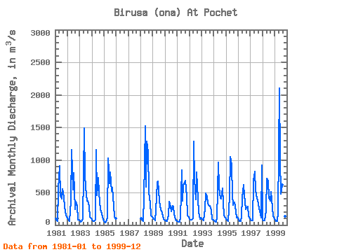
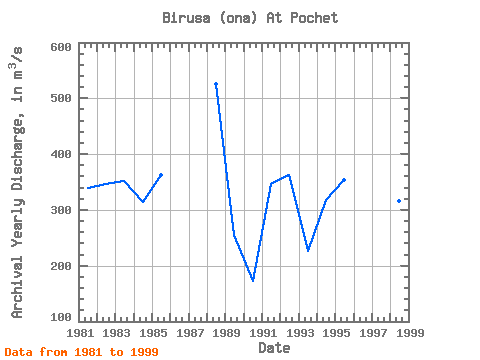
| Year | Jan | Feb | Mar | Apr | May | Jun | Jul | Aug | Sep | Oct | Nov | Dec | Annual | 1981 | 102.00 | 69.60 | 63.80 | 549.00 | 913.00 | 449.00 | 405.00 | 551.00 | 423.00 | 280.00 | 149.00 | 119.00 | 339.45 | 1982 | 87.70 | 70.80 | 63.70 | 355.00 | 1160.00 | 544.00 | 804.00 | 247.00 | 358.00 | 299.00 | 82.60 | 75.80 | 345.63 | 1983 | 66.60 | 47.90 | 65.20 | 89.90 | 1490.00 | 748.00 | 454.00 | 375.00 | 368.00 | 287.00 | 119.00 | 103.00 | 351.13 | 1984 | 85.80 | 53.90 | 62.60 | 78.60 | 1160.00 | 460.00 | 730.00 | 489.00 | 232.00 | 213.00 | 134.00 | 75.90 | 314.57 | 1985 | 51.10 | 39.90 | 43.10 | 114.00 | 1030.00 | 640.00 | 812.00 | 522.00 | 576.00 | 295.00 | 121.00 | 100.00 | 362.01 | 1988 | 101.00 | 78.70 | 61.70 | 430.00 | 1520.00 | 590.00 | 1290.00 | 1120.00 | 503.00 | 336.00 | 148.00 | 120.00 | 524.87 | 1989 | 105.00 | 88.10 | 74.20 | 220.00 | 661.00 | 672.00 | 380.00 | 284.00 | 214.00 | 187.00 | 90.20 | 76.70 | 254.35 | 1990 | 65.90 | 55.50 | 60.10 | 141.00 | 363.00 | 289.00 | 213.00 | 293.00 | 269.00 | 181.00 | 75.40 | 73.00 | 173.24 | 1991 | 61.10 | 52.20 | 48.20 | 128.00 | 846.00 | 369.00 | 612.00 | 648.00 | 679.00 | 450.00 | 150.00 | 123.00 | 347.21 | 1992 | 96.20 | 81.00 | 76.60 | 106.00 | 1280.00 | 697.00 | 395.00 | 813.00 | 402.00 | 197.00 | 93.20 | 111.00 | 362.33 | 1993 | 89.30 | 76.10 | 71.90 | 240.00 | 493.00 | 431.00 | 326.00 | 293.00 | 300.00 | 228.00 | 86.90 | 77.30 | 226.04 | 1994 | 68.00 | 55.90 | 53.10 | 112.00 | 960.00 | 578.00 | 416.00 | 399.00 | 562.00 | 341.00 | 147.00 | 112.00 | 317.00 | 1995 | 87.20 | 69.10 | 56.20 | 435.00 | 1050.00 | 924.00 | 455.00 | 305.00 | 348.00 | 283.00 | 108.00 | 127.00 | 353.96 | 1996 | 88.80 | 58.10 | 56.80 | 119.00 | 427.00 | 620.00 | 452.00 | 246.00 | 266.00 | 288.00 | 134.00 | 105.00 | 238.39 | 1997 | 85.40 | 73.90 | 70.40 | 680.00 | 819.00 | 536.00 | 404.00 | 388.00 | 253.00 | 223.00 | 117.00 | 922.00 | 380.98 | 1998 | 78.00 | 73.00 | 68.80 | 218.00 | 718.00 | 674.00 | 422.00 | 370.00 | 515.00 | 390.00 | 145.00 | 109.00 | 315.07 | 1999 | 76.90 | 56.70 | 54.10 | 191.00 | 2100.00 | 1020.00 | 480.00 | 617.00 | 372.00 | 218.00 | 134.00 | 124.00 | 453.64 |
|---|
 Return to R-Arctic Net Home Page