|
|
|||||||||||||||||
| Point ID: 8275 | Downloads | Plots | Site Data | Code: 8397 |
|
|
|||||||||||||||||
| Download | |
|---|---|
| Site Descriptor Information | Site Time Series Data |
| Link to all available data | |

|
|
| View: | Statistics | Time Series |
| Units: | mm |
| Statistic | Jan | Feb | Mar | Apr | May | Jun | Jul | Aug | Sep | Oct | Nov | Dec | Annual |
|---|---|---|---|---|---|---|---|---|---|---|---|---|---|
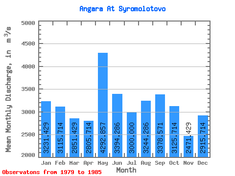
| Mean | 3231.43 | 3115.71 | 2851.43 | 2805.71 | 4292.86 | 3394.29 | 3000.00 | 3244.29 | 3378.57 | 3125.71 | 2471.43 | 2915.71 | 3152.26 |
| Standard Deviation | 648.03 | 880.34 | 958.46 | 790.57 | 437.48 | 380.83 | 101.16 | 470.81 | 838.84 | 400.45 | 772.06 | 489.21 | 472.81 |
| Min | 2010.00 | 2030.00 | 1650.00 | 1500.00 | 3420.00 | 3090.00 | 2900.00 | 2970.00 | 2900.00 | 2640.00 | 1530.00 | 2150.00 | 2593.33 |
| Max | 4180.00 | 4350.00 | 4390.00 | 3790.00 | 4750.00 | 4220.00 | 3140.00 | 4290.00 | 5260.00 | 3740.00 | 3610.00 | 3530.00 | 3994.17 |
| Coefficient of Variation | 0.20 | 0.28 | 0.34 | 0.28 | 0.10 | 0.11 | 0.03 | 0.14 | 0.25 | 0.13 | 0.31 | 0.17 | 0.15 |
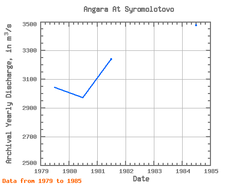
| Year | Jan | Feb | Mar | Apr | May | Jun | Jul | Aug | Sep | Oct | Nov | Dec | Annual | 1979 | 3330.00 | 2760.00 | 2610.00 | 3040.00 | 4270.00 | 3270.00 | 2970.00 | 3190.00 | 3190.00 | 2960.00 | 1850.00 | 3090.00 | 3044.17 | 1980 | 2990.00 | 2970.00 | 2970.00 | 2590.00 | 3420.00 | 3270.00 | 2980.00 | 2970.00 | 2980.00 | 2990.00 | 2570.00 | 2940.00 | 2970.00 | 1981 | 3390.00 | 3470.00 | 2920.00 | 2520.00 | 4700.00 | 3380.00 | 3140.00 | 3080.00 | 3090.00 | 3130.00 | 2860.00 | 3210.00 | 3240.83 | 1982 | 3330.00 | 2030.00 | 1650.00 | 1500.00 | 4220.00 | 3090.00 | 2900.00 | 2990.00 | 2900.00 | 2830.00 | 1530.00 | 2150.00 | 2593.33 | 1983 | 2010.00 | 2200.00 | 1820.00 | 2500.00 | 4360.00 | 4220.00 | 2900.00 | 3200.00 | 2980.00 | 2640.00 | 1790.00 | 2360.00 | 2748.33 | 1984 | 3390.00 | 4030.00 | 3600.00 | 3790.00 | 4330.00 | 3140.00 | 2970.00 | 2990.00 | 3250.00 | 3590.00 | 3090.00 | 3530.00 | 3475.00 | 1985 | 4180.00 | 4350.00 | 4390.00 | 3700.00 | 4750.00 | 3390.00 | 3140.00 | 4290.00 | 5260.00 | 3740.00 | 3610.00 | 3130.00 | 3994.17 |
|---|
 Return to R-Arctic Net Home Page