|
|
|||||||||||||||||
| Point ID: 8261 | Downloads | Plots | Site Data | Code: 8368 |
|
|
|||||||||||||||||
| Download | |
|---|---|
| Site Descriptor Information | Site Time Series Data |
| Link to all available data | |
|
|
| View: | Statistics | Time Series |
| Units: | mm |
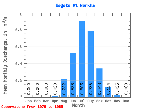
| Statistic | Jan | Feb | Mar | Apr | May | Jun | Jul | Aug | Sep | Oct | Nov | Dec | Annual |
|---|---|---|---|---|---|---|---|---|---|---|---|---|---|
| Mean | 0.00 | 0.00 | 0.00 | 0.02 | 0.22 | 0.53 | 0.91 | 0.79 | 0.34 | 0.12 | 0.03 | 0.00 | 0.24 |
| Standard Deviation | 0.00 | 0.00 | 0.00 | 0.04 | 0.09 | 0.31 | 0.67 | 0.44 | 0.25 | 0.09 | 0.02 | 0.00 | 0.12 |
| Min | 0.00 | 0.00 | 0.00 | 0.00 | 0.10 | 0.17 | 0.09 | 0.25 | 0.12 | 0.04 | 0.01 | 0.00 | 0.09 |
| Max | 0.00 | 0.00 | 0.00 | 0.13 | 0.42 | 1.12 | 2.12 | 1.39 | 0.85 | 0.32 | 0.07 | 0.00 | 0.44 |
| Coefficient of Variation | 2.00 | 0.42 | 0.58 | 0.74 | 0.56 | 0.74 | 0.69 | 0.73 | 0.51 |
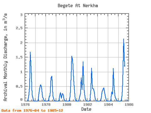
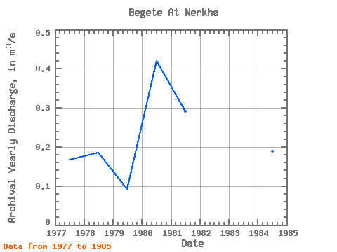
| Year | Jan | Feb | Mar | Apr | May | Jun | Jul | Aug | Sep | Oct | Nov | Dec | Annual | 1976 | 0.01 | 0.14 | 0.46 | 1.67 | 1.10 | 0.21 | 0.08 | 0.01 | 0.00 | 1977 | 0.00 | 0.00 | 0.00 | 0.01 | 0.28 | 0.47 | 0.55 | 0.47 | 0.14 | 0.07 | 0.02 | 0.00 | 0.17 | 1978 | 0.00 | 0.00 | 0.00 | 0.01 | 0.17 | 0.17 | 0.79 | 0.84 | 0.19 | 0.04 | 0.02 | 0.00 | 0.19 | 1979 | 0.00 | 0.00 | 0.00 | 0.01 | 0.19 | 0.28 | 0.09 | 0.25 | 0.22 | 0.07 | 0.01 | 0.00 | 0.09 | 1980 | 0.00 | 0.00 | 0.00 | 0.00 | 0.17 | 0.82 | 1.53 | 1.39 | 0.74 | 0.32 | 0.07 | 0.00 | 0.42 | 1981 | 0.00 | 0.00 | 0.00 | 0.13 | 0.25 | 0.79 | 0.39 | 1.34 | 0.41 | 0.14 | 0.04 | 0.00 | 0.29 | 1982 | 0.00 | 0.00 | 0.00 | 0.02 | 0.42 | 1.12 | 0.42 | 0.41 | 0.29 | 0.10 | 0.02 | 0.00 | 0.23 | 1983 | 0.00 | 0.00 | 0.00 | 0.00 | 0.10 | 0.30 | 0.38 | 0.45 | 0.26 | 0.13 | 0.03 | 0.00 | 0.14 | 1984 | 0.00 | 0.00 | 0.00 | 0.00 | 0.31 | 0.23 | 1.11 | 0.41 | 0.12 | 0.07 | 0.02 | 0.00 | 0.19 | 1985 | 0.00 | 0.00 | 0.00 | 0.01 | 0.19 | 0.64 | 2.12 | 1.20 | 0.85 | 0.22 | 0.03 | 0.00 | 0.44 |
|---|
 Return to R-Arctic Net Home Page