|
|
|||||||||||||||||
| Point ID: 8253 | Downloads | Plots | Site Data | Code: 8345 |
|
|
|||||||||||||||||
| Download | |
|---|---|
| Site Descriptor Information | Site Time Series Data |
| Link to all available data | |
|
|
| View: | Statistics | Time Series |
| Units: | mm |
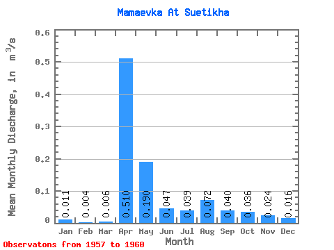
| Statistic | Jan | Feb | Mar | Apr | May | Jun | Jul | Aug | Sep | Oct | Nov | Dec | Annual |
|---|---|---|---|---|---|---|---|---|---|---|---|---|---|
| Mean | 0.01 | 0.00 | 0.01 | 0.51 | 0.19 | 0.05 | 0.04 | 0.07 | 0.04 | 0.04 | 0.02 | 0.02 | 0.09 |
| Standard Deviation | 0.01 | 0.00 | 0.00 | 0.30 | 0.04 | 0.02 | 0.02 | 0.09 | 0.03 | 0.02 | 0.02 | 0.01 | 0.05 |
| Min | 0.01 | 0.00 | 0.00 | 0.23 | 0.16 | 0.03 | 0.03 | 0.01 | 0.02 | 0.02 | 0.01 | 0.01 | 0.05 |
| Max | 0.02 | 0.01 | 0.01 | 0.82 | 0.24 | 0.06 | 0.07 | 0.21 | 0.09 | 0.07 | 0.05 | 0.03 | 0.14 |
| Coefficient of Variation | 0.55 | 0.46 | 0.63 | 0.58 | 0.23 | 0.35 | 0.61 | 1.30 | 0.84 | 0.61 | 0.82 | 0.46 | 0.56 |
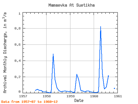
| Year | Jan | Feb | Mar | Apr | May | Jun | Jul | Aug | Sep | Oct | Nov | Dec | Annual | 1957 | 0.03 | 0.05 | 0.03 | 0.03 | 0.01 | 0.01 | 1958 | 0.01 | 0.00 | 0.00 | 0.48 | 0.17 | 0.06 | 0.03 | 0.02 | 0.02 | 0.03 | 0.02 | 0.02 | 0.07 | 1959 | 0.02 | 0.00 | 0.01 | 0.23 | 0.16 | 0.03 | 0.03 | 0.01 | 0.02 | 0.02 | 0.01 | 0.01 | 0.05 | 1960 | 0.01 | 0.01 | 0.01 | 0.82 | 0.24 | 0.05 | 0.07 | 0.21 | 0.09 | 0.07 | 0.05 | 0.03 | 0.14 |
|---|
 Return to R-Arctic Net Home Page