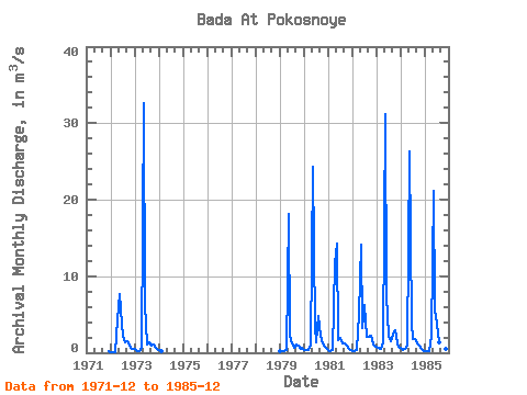
| Point ID: 8219 | Downloads | Plots | Site Data | Code: 8249 |
| Download | |
|---|---|
| Site Descriptor Information | Site Time Series Data |
| Link to all available data | |

|

|
| View: | Statistics | Time Series |
| Units: | mm |
| Statistic | Jan | Feb | Mar | Apr | May | Jun | Jul | Aug | Sep | Oct | Nov | Dec | Annual |
|---|---|---|---|---|---|---|---|---|---|---|---|---|---|
| Mean | 0.36 | 0.28 | 0.31 | 3.06 | 21.09 | 4.17 | 2.42 | 1.81 | 1.71 | 1.38 | 0.72 | 0.51 | 3.15 |
| Standard Deviation | 0.19 | 0.15 | 0.13 | 3.64 | 8.34 | 1.96 | 1.66 | 1.21 | 0.68 | 0.71 | 0.26 | 0.24 | 0.77 |
| Min | 0.14 | 0.10 | 0.09 | 0.39 | 7.68 | 1.63 | 1.13 | 0.65 | 0.97 | 0.90 | 0.49 | 0.21 | 1.92 |
| Max | 0.73 | 0.63 | 0.49 | 11.70 | 32.60 | 7.55 | 6.26 | 4.84 | 2.94 | 2.93 | 1.26 | 0.93 | 4.42 |
| Coefficient of Variation | 0.53 | 0.54 | 0.42 | 1.19 | 0.40 | 0.47 | 0.68 | 0.67 | 0.40 | 0.51 | 0.37 | 0.48 | 0.24 |
| Year | Jan | Feb | Mar | Apr | May | Jun | Jul | Aug | Sep | Oct | Nov | Dec | Annual | 1971 | 0.21 | 1972 | 0.14 | 0.10 | 0.09 | 4.37 | 7.68 | 3.61 | 2.16 | 1.42 | 1.44 | 0.90 | 0.55 | 0.54 | 1.92 | 1973 | 0.45 | 0.24 | 0.22 | 0.61 | 32.60 | 6.42 | 1.13 | 1.32 | 0.97 | 1.01 | 0.67 | 0.41 | 3.84 | 1974 | 0.32 | 0.21 | 1979 | 0.18 | 0.18 | 0.27 | 0.39 | 18.10 | 2.25 | 1.16 | 0.65 | 1.02 | 0.90 | 0.54 | 0.68 | 2.19 | 1980 | 0.39 | 0.38 | 0.43 | 0.87 | 24.30 | 3.41 | 1.39 | 4.84 | 2.19 | 1.28 | 0.81 | 0.45 | 3.40 | 1981 | 0.40 | 0.23 | 0.36 | 11.70 | 14.30 | 1.63 | 1.87 | 1.20 | 1.29 | 0.93 | 0.49 | 0.32 | 2.89 | 1982 | 0.25 | 0.21 | 0.29 | 5.02 | 14.10 | 3.18 | 6.26 | 2.12 | 2.04 | 2.20 | 1.02 | 0.93 | 3.13 | 1983 | 0.73 | 0.63 | 0.49 | 1.34 | 31.20 | 7.55 | 2.27 | 1.53 | 2.30 | 2.93 | 1.26 | 0.84 | 4.42 | 1984 | 0.60 | 0.37 | 0.44 | 0.97 | 26.30 | 3.83 | 1.73 | 1.78 | 1.22 | 1.00 | 0.57 | 0.24 | 3.25 | 1985 | 0.17 | 0.23 | 0.20 | 2.24 | 21.20 | 5.62 | 3.85 | 1.41 | 2.94 | 1.29 | 0.56 | 0.44 | 3.35 |
|---|
 Return to R-Arctic Net Home Page