|
|
|||||||||||||||||
| Point ID: 8216 | Downloads | Plots | Site Data | Code: 8243 |
|
|
|||||||||||||||||
| Download | |
|---|---|
| Site Descriptor Information | Site Time Series Data |
| Link to all available data | |
|
|
| View: | Statistics | Time Series |
| Units: | mm |
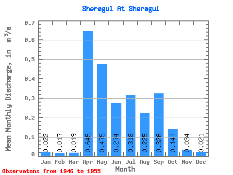
| Statistic | Jan | Feb | Mar | Apr | May | Jun | Jul | Aug | Sep | Oct | Nov | Dec | Annual |
|---|---|---|---|---|---|---|---|---|---|---|---|---|---|
| Mean | 0.02 | 0.02 | 0.02 | 0.65 | 0.47 | 0.27 | 0.32 | 0.23 | 0.33 | 0.14 | 0.03 | 0.02 | 0.21 |
| Standard Deviation | 0.01 | 0.01 | 0.01 | 0.64 | 0.31 | 0.25 | 0.25 | 0.19 | 0.36 | 0.08 | 0.01 | 0.01 | 0.13 |
| Min | 0.01 | 0.00 | 0.01 | 0.07 | 0.18 | 0.10 | 0.07 | 0.07 | 0.06 | 0.05 | 0.02 | 0.01 | 0.09 |
| Max | 0.04 | 0.03 | 0.03 | 1.61 | 1.08 | 0.90 | 0.80 | 0.59 | 0.94 | 0.31 | 0.06 | 0.04 | 0.39 |
| Coefficient of Variation | 0.46 | 0.49 | 0.48 | 0.98 | 0.66 | 0.90 | 0.80 | 0.84 | 1.09 | 0.56 | 0.40 | 0.53 | 0.60 |
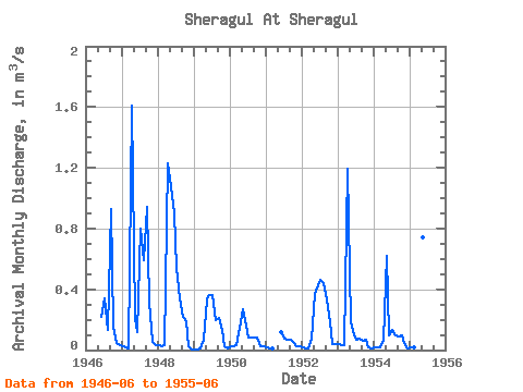
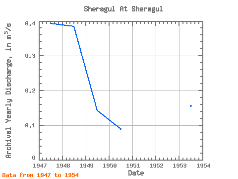
| Year | Jan | Feb | Mar | Apr | May | Jun | Jul | Aug | Sep | Oct | Nov | Dec | Annual | 1946 | 0.22 | 0.34 | 0.13 | 0.93 | 0.15 | 0.04 | 0.03 | 1947 | 0.03 | 0.02 | 0.01 | 1.61 | 0.21 | 0.12 | 0.80 | 0.59 | 0.94 | 0.31 | 0.06 | 0.03 | 0.39 | 1948 | 0.03 | 0.03 | 0.03 | 1.23 | 1.08 | 0.90 | 0.54 | 0.34 | 0.22 | 0.19 | 0.02 | 0.01 | 0.39 | 1949 | 0.01 | 0.00 | 0.01 | 0.07 | 0.33 | 0.36 | 0.36 | 0.20 | 0.21 | 0.13 | 0.02 | 0.01 | 0.14 | 1950 | 0.02 | 0.02 | 0.03 | 0.15 | 0.27 | 0.20 | 0.08 | 0.08 | 0.08 | 0.09 | 0.03 | 0.02 | 0.09 | 1951 | 0.02 | 0.01 | 0.01 | 0.12 | 0.08 | 0.07 | 0.07 | 0.05 | 0.03 | 0.02 | 1952 | 0.02 | 0.01 | 0.01 | 0.08 | 0.37 | 0.43 | 0.46 | 0.44 | 0.33 | 0.18 | 0.04 | 0.04 | 0.20 | 1953 | 0.04 | 0.03 | 0.03 | 1.19 | 0.18 | 0.10 | 0.07 | 0.07 | 0.06 | 0.07 | 0.02 | 0.01 | 0.16 | 1954 | 0.02 | 0.01 | 0.02 | 0.07 | 0.62 | 0.10 | 0.13 | 0.10 | 0.09 | 0.09 | 0.05 | 0.01 | 0.11 | 1955 | 0.02 | 0.01 | 0.01 | 0.77 | 0.74 | 0.20 |
|---|
 Return to R-Arctic Net Home Page