|
|
|||||||||||||||||
| Point ID: 8213 | Downloads | Plots | Site Data | Code: 8228 |
|
|
|||||||||||||||||
| Download | |
|---|---|
| Site Descriptor Information | Site Time Series Data |
| Link to all available data | |
|
|
| View: | Statistics | Time Series |
| Units: | mm |
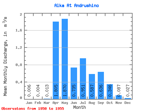
| Statistic | Jan | Feb | Mar | Apr | May | Jun | Jul | Aug | Sep | Oct | Nov | Dec | Annual |
|---|---|---|---|---|---|---|---|---|---|---|---|---|---|
| Mean | 0.01 | 0.00 | 0.01 | 1.81 | 1.87 | 0.73 | 0.95 | 0.59 | 0.64 | 0.35 | 0.09 | 0.03 | 0.68 |
| Standard Deviation | 0.01 | 0.01 | 0.02 | 1.07 | 0.56 | 0.51 | 0.65 | 0.67 | 0.81 | 0.24 | 0.05 | 0.04 | 0.24 |
| Min | 0.00 | 0.00 | 0.00 | 0.35 | 1.46 | 0.23 | 0.30 | 0.20 | 0.09 | 0.09 | 0.03 | 0.00 | 0.47 |
| Max | 0.02 | 0.01 | 0.03 | 3.12 | 2.84 | 1.29 | 1.89 | 1.77 | 2.23 | 0.65 | 0.16 | 0.07 | 0.94 |
| Coefficient of Variation | 1.73 | 1.73 | 1.19 | 0.60 | 0.30 | 0.69 | 0.68 | 1.14 | 1.27 | 0.70 | 0.56 | 1.38 | 0.35 |
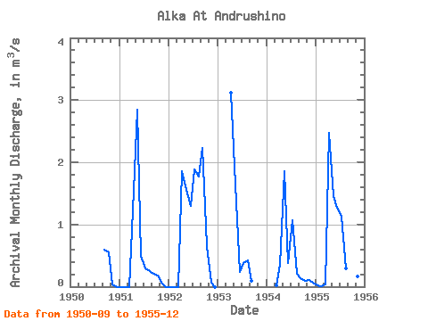
| Year | Jan | Feb | Mar | Apr | May | Jun | Jul | Aug | Sep | Oct | Nov | Dec | Annual | 1950 | 0.59 | 0.55 | 0.03 | 0.00 | 1951 | 0.00 | 0.00 | 0.00 | 1.23 | 2.84 | 0.50 | 0.30 | 0.25 | 0.20 | 0.18 | 0.07 | 0.00 | 0.47 | 1952 | 0.00 | 0.00 | 0.00 | 1.85 | 1.55 | 1.29 | 1.89 | 1.77 | 2.23 | 0.65 | 0.06 | 0.00 | 0.94 | 1953 | 3.12 | 1.64 | 0.23 | 0.38 | 0.42 | 0.09 | 1954 | 0.02 | 0.35 | 1.86 | 0.38 | 1.06 | 0.20 | 0.13 | 0.09 | 0.11 | 0.06 | 1955 | 0.02 | 0.01 | 0.03 | 2.47 | 1.46 | 1.27 | 1.12 | 0.29 | 0.57 | 0.26 | 0.16 | 0.07 | 0.65 |
|---|
 Return to R-Arctic Net Home Page