|
|
|||||||||||||||||
| Point ID: 8123 | Downloads | Plots | Site Data | Code: 1606 |
|
|
|||||||||||||||||
| Download | |
|---|---|
| Site Descriptor Information | Site Time Series Data |
| Link to all available data | |
|
|
| View: | Statistics | Time Series |
| Units: | mm |
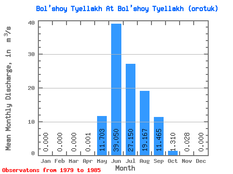
| Statistic | Jan | Feb | Mar | Apr | May | Jun | Jul | Aug | Sep | Oct | Nov | Dec | Annual |
|---|---|---|---|---|---|---|---|---|---|---|---|---|---|
| Mean | 0.00 | 0.00 | 0.00 | 0.00 | 11.70 | 39.05 | 27.15 | 19.17 | 11.46 | 1.31 | 0.03 | 0.00 | 9.16 |
| Standard Deviation | 0.00 | 0.00 | 0.00 | 0.00 | 5.71 | 22.76 | 9.28 | 6.32 | 6.49 | 0.74 | 0.02 | 0.00 | 2.01 |
| Min | 0.00 | 0.00 | 0.00 | 0.00 | 2.79 | 17.80 | 12.50 | 11.30 | 5.17 | 0.83 | 0.00 | 0.00 | 6.58 |
| Max | 0.00 | 0.00 | 0.00 | 0.00 | 20.40 | 72.90 | 39.20 | 27.70 | 22.70 | 2.80 | 0.05 | 0.00 | 11.13 |
| Coefficient of Variation | 2.45 | 0.49 | 0.58 | 0.34 | 0.33 | 0.57 | 0.57 | 0.75 | 0.22 |
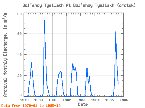
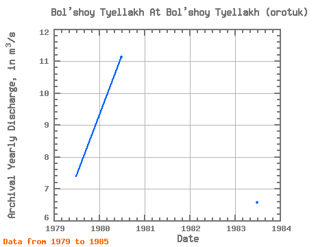
| Year | Jan | Feb | Mar | Apr | May | Jun | Jul | Aug | Sep | Oct | Nov | Dec | Annual | 1979 | 0.00 | 0.00 | 0.00 | 0.00 | 9.93 | 17.80 | 32.20 | 19.80 | 8.00 | 0.83 | 0.02 | 0.00 | 7.38 | 1980 | 0.00 | 0.00 | 0.00 | 0.00 | 2.79 | 72.90 | 39.20 | 11.30 | 6.42 | 0.91 | 0.00 | 0.00 | 11.13 | 1981 | 0.00 | 0.00 | 0.00 | 0.00 | 13.70 | 20.90 | 22.90 | 24.20 | 13.90 | 2.80 | 0.04 | 0.00 | 8.20 | 1982 | 0.00 | 0.00 | 0.00 | 0.00 | 20.40 | 32.00 | 24.50 | 27.70 | 22.70 | 1.21 | 0.05 | 0.00 | 10.71 | 1983 | 0.00 | 0.00 | 0.00 | 0.00 | 12.20 | 29.00 | 12.50 | 19.10 | 5.17 | 0.97 | 0.01 | 0.00 | 6.58 | 1985 | 0.00 | 0.00 | 0.00 | 0.00 | 11.20 | 61.70 | 31.60 | 12.90 | 12.60 | 1.14 | 0.04 | 0.00 | 10.93 |
|---|
 Return to R-Arctic Net Home Page