|
|
|||||||||||||||||
| Point ID: 8091 | Downloads | Plots | Site Data | Code: 1517 |
|
|
|||||||||||||||||
| Download | |
|---|---|
| Site Descriptor Information | Site Time Series Data |
| Link to all available data | |
|
|
| View: | Statistics | Time Series |
| Units: | mm |
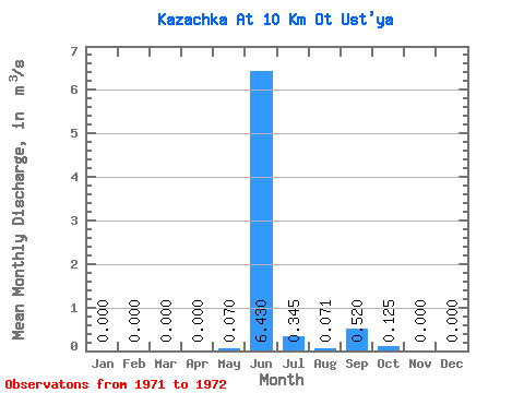
| Statistic | Jan | Feb | Mar | Apr | May | Jun | Jul | Aug | Sep | Oct | Nov | Dec | Annual |
|---|---|---|---|---|---|---|---|---|---|---|---|---|---|
| Mean | 0.00 | 0.00 | 0.00 | 0.00 | 0.07 | 6.43 | 0.34 | 0.07 | 0.52 | 0.12 | 0.00 | 0.00 | 0.63 |
| Standard Deviation | 0.00 | 0.00 | 0.00 | 0.00 | 0.10 | 0.33 | 0.11 | 0.06 | 0.57 | 0.11 | 0.00 | 0.00 | 0.09 |
| Min | 0.00 | 0.00 | 0.00 | 0.00 | 0.00 | 6.20 | 0.27 | 0.03 | 0.12 | 0.05 | 0.00 | 0.00 | 0.57 |
| Max | 0.00 | 0.00 | 0.00 | 0.00 | 0.14 | 6.66 | 0.42 | 0.11 | 0.92 | 0.20 | 0.00 | 0.00 | 0.69 |
| Coefficient of Variation | 1.41 | 0.05 | 0.31 | 0.78 | 1.09 | 0.85 | 0.14 |
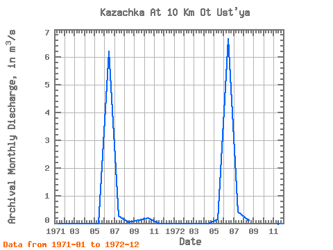
| Year | Jan | Feb | Mar | Apr | May | Jun | Jul | Aug | Sep | Oct | Nov | Dec | Annual | 1971 | 0.00 | 0.00 | 0.00 | 0.00 | 0.00 | 6.20 | 0.27 | 0.03 | 0.12 | 0.20 | 0.00 | 0.00 | 0.57 | 1972 | 0.00 | 0.00 | 0.00 | 0.00 | 0.14 | 6.66 | 0.42 | 0.11 | 0.92 | 0.05 | 0.00 | 0.00 | 0.69 |
|---|
 Return to R-Arctic Net Home Page