|
|
|||||||||||||||||
| Point ID: 8061 | Downloads | Plots | Site Data | Code: 1269 |
|
|
|||||||||||||||||
| Download | |
|---|---|
| Site Descriptor Information | Site Time Series Data |
| Link to all available data | |
|
|
| View: | Statistics | Time Series |
| Units: | mm |
| Statistic | Jan | Feb | Mar | Apr | May | Jun | Jul | Aug | Sep | Oct | Nov | Dec | Annual |
|---|---|---|---|---|---|---|---|---|---|---|---|---|---|
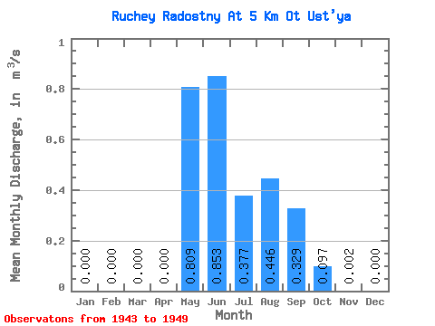
| Mean | 0.00 | 0.00 | 0.00 | 0.00 | 0.81 | 0.85 | 0.38 | 0.45 | 0.33 | 0.10 | 0.00 | 0.00 | 0.24 |
| Standard Deviation | 0.00 | 0.00 | 0.00 | 0.00 | 0.53 | 0.78 | 0.11 | 0.21 | 0.21 | 0.14 | 0.00 | 0.00 | 0.08 |
| Min | 0.00 | 0.00 | 0.00 | 0.00 | 0.00 | 0.32 | 0.18 | 0.15 | 0.14 | 0.01 | 0.00 | 0.00 | 0.12 |
| Max | 0.00 | 0.00 | 0.00 | 0.00 | 1.49 | 2.53 | 0.52 | 0.67 | 0.65 | 0.39 | 0.01 | 0.00 | 0.32 |
| Coefficient of Variation | 0.65 | 0.91 | 0.29 | 0.47 | 0.65 | 1.48 | 2.02 | 2.65 | 0.32 |
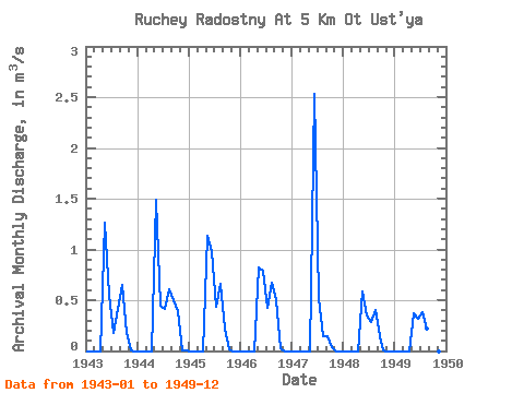
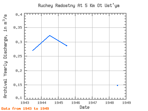
| Year | Jan | Feb | Mar | Apr | May | Jun | Jul | Aug | Sep | Oct | Nov | Dec | Annual | 1943 | 0.00 | 0.00 | 0.00 | 0.00 | 1.26 | 0.55 | 0.18 | 0.41 | 0.65 | 0.18 | 0.00 | 0.00 | 0.27 | 1944 | 0.00 | 0.00 | 0.00 | 0.00 | 1.49 | 0.45 | 0.41 | 0.61 | 0.50 | 0.39 | 0.01 | 0.00 | 0.32 | 1945 | 0.00 | 0.00 | 0.00 | 0.00 | 1.13 | 0.98 | 0.44 | 0.66 | 0.22 | 0.01 | 0.00 | 0.00 | 0.29 | 1946 | 0.00 | 0.00 | 0.00 | 0.00 | 0.82 | 0.79 | 0.42 | 0.67 | 0.50 | 0.03 | 0.00 | 0.00 | 0.27 | 1947 | 0.00 | 0.00 | 0.00 | 0.00 | 0.00 | 2.53 | 0.52 | 0.15 | 0.15 | 0.04 | 0.00 | 0.00 | 0.28 | 1948 | 0.00 | 0.00 | 0.00 | 0.00 | 0.59 | 0.35 | 0.29 | 0.40 | 0.14 | 0.01 | 0.00 | 0.00 | 0.15 | 1949 | 0.00 | 0.00 | 0.00 | 0.00 | 0.37 | 0.32 | 0.38 | 0.22 | 0.14 | 0.01 | 0.00 | 0.00 | 0.12 |
|---|
 Return to R-Arctic Net Home Page