|
|
|||||||||||||||||
| Point ID: 803 | Downloads | Plots | Site Data | Code: 07KF015 |
|
|
|||||||||||||||||
| Download | |
|---|---|
| Site Descriptor Information | Site Time Series Data |
| Link to all available data | |
|
|
| View: | Statistics | Time Series |
| Units: | mm |
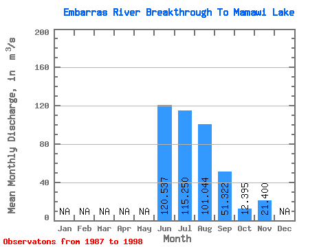
| Statistic | Jan | Feb | Mar | Apr | May | Jun | Jul | Aug | Sep | Oct | Nov | Dec | Annual |
|---|---|---|---|---|---|---|---|---|---|---|---|---|---|
| Mean | 120.54 | 115.25 | 101.04 | 51.32 | 12.39 | 21.40 | |||||||
| Standard Deviation | 60.32 | 56.41 | 51.65 | 27.62 | 5.52 | ||||||||
| Min | 55.10 | 34.80 | 42.30 | 23.60 | 8.49 | 21.40 | |||||||
| Max | 218.00 | 209.00 | 196.00 | 106.00 | 16.30 | 21.40 | |||||||
| Coefficient of Variation | 0.50 | 0.49 | 0.51 | 0.54 | 0.45 |
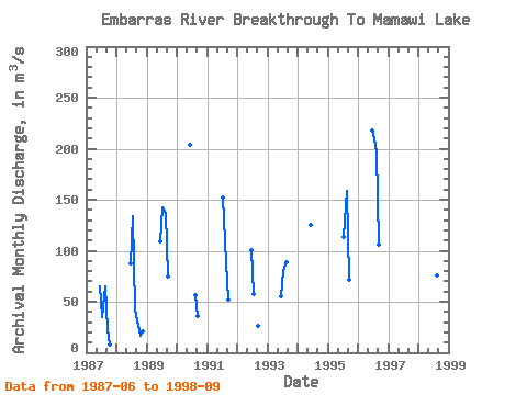
| Year | Jan | Feb | Mar | Apr | May | Jun | Jul | Aug | Sep | Oct | Nov | Dec | Annual | 1987 | 65.10 | 34.80 | 65.00 | 23.60 | 8.49 | 1988 | 87.10 | 134.00 | 42.30 | 31.70 | 16.30 | 21.40 | 1989 | 109.00 | 142.00 | 137.00 | 75.00 | 1990 | 204.00 | 56.30 | 35.60 | 1991 | 152.00 | 88.60 | 52.20 | 1992 | 101.00 | 57.60 | 26.50 | 1993 | 55.10 | 79.60 | 89.20 | 1994 | 125.00 | 1995 | 113.00 | 159.00 | 71.40 | 1996 | 218.00 | 209.00 | 196.00 | 106.00 | 1998 | 76.00 | 39.90 |
|---|
 Return to R-Arctic Net Home Page