|
|
|||||||||||||||||
| Point ID: 8029 | Downloads | Plots | Site Data | Code: 1035 |
|
|
|||||||||||||||||
| Download | |
|---|---|
| Site Descriptor Information | Site Time Series Data |
| Link to all available data | |
|

|
| View: | Statistics | Time Series |
| Units: | mm |
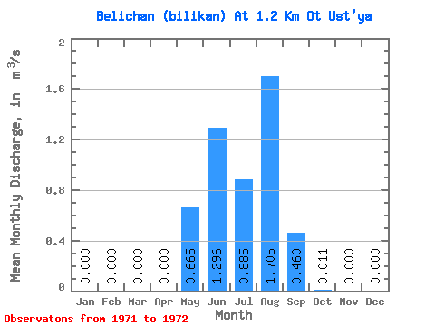
| Statistic | Jan | Feb | Mar | Apr | May | Jun | Jul | Aug | Sep | Oct | Nov | Dec | Annual |
|---|---|---|---|---|---|---|---|---|---|---|---|---|---|
| Mean | 0.00 | 0.00 | 0.00 | 0.00 | 0.67 | 1.30 | 0.89 | 1.71 | 0.46 | 0.01 | 0.00 | 0.00 | 0.42 |
| Standard Deviation | 0.00 | 0.00 | 0.00 | 0.00 | 0.05 | 0.19 | 0.80 | 1.96 | 0.49 | 0.00 | 0.00 | 0.00 | 0.16 |
| Min | 0.00 | 0.00 | 0.00 | 0.00 | 0.63 | 1.16 | 0.32 | 0.32 | 0.11 | 0.01 | 0.00 | 0.00 | 0.31 |
| Max | 0.00 | 0.00 | 0.00 | 0.00 | 0.70 | 1.43 | 1.45 | 3.09 | 0.81 | 0.01 | 0.00 | 0.00 | 0.53 |
| Coefficient of Variation | 0.07 | 0.15 | 0.90 | 1.15 | 1.08 | 0.03 | 0.38 |
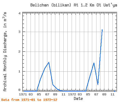
| Year | Jan | Feb | Mar | Apr | May | Jun | Jul | Aug | Sep | Oct | Nov | Dec | Annual | 1971 | 0.00 | 0.00 | 0.00 | 0.00 | 0.63 | 1.16 | 1.45 | 0.32 | 0.11 | 0.01 | 0.00 | 0.00 | 0.31 | 1972 | 0.00 | 0.00 | 0.00 | 0.00 | 0.70 | 1.43 | 0.32 | 3.09 | 0.81 | 0.01 | 0.00 | 0.00 | 0.53 |
|---|
 Return to R-Arctic Net Home Page