|
|
|||||||||||||||||
| Point ID: 7985 | Downloads | Plots | Site Data | Code: 3631 |
|
|
|||||||||||||||||
| Download | |
|---|---|
| Site Descriptor Information | Site Time Series Data |
| Link to all available data | |
|
|
| View: | Statistics | Time Series |
| Units: | mm |
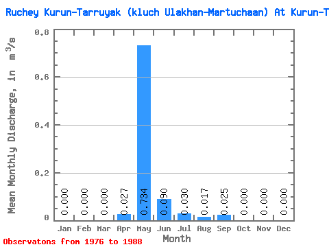
| Statistic | Jan | Feb | Mar | Apr | May | Jun | Jul | Aug | Sep | Oct | Nov | Dec | Annual |
|---|---|---|---|---|---|---|---|---|---|---|---|---|---|
| Mean | 0.00 | 0.00 | 0.00 | 0.03 | 0.73 | 0.09 | 0.03 | 0.02 | 0.03 | 0.00 | 0.00 | 0.00 | 0.07 |
| Standard Deviation | 0.00 | 0.00 | 0.00 | 0.05 | 0.16 | 0.09 | 0.06 | 0.05 | 0.07 | 0.00 | 0.00 | 0.00 | 0.01 |
| Min | 0.00 | 0.00 | 0.00 | 0.00 | 0.43 | 0.00 | 0.00 | 0.00 | 0.00 | 0.00 | 0.00 | 0.00 | 0.04 |
| Max | 0.00 | 0.00 | 0.00 | 0.16 | 0.93 | 0.28 | 0.18 | 0.16 | 0.21 | 0.00 | 0.00 | 0.00 | 0.09 |
| Coefficient of Variation | 1.89 | 0.22 | 0.94 | 1.84 | 3.04 | 2.75 | 3.16 | 0.20 |
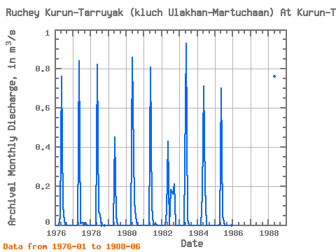
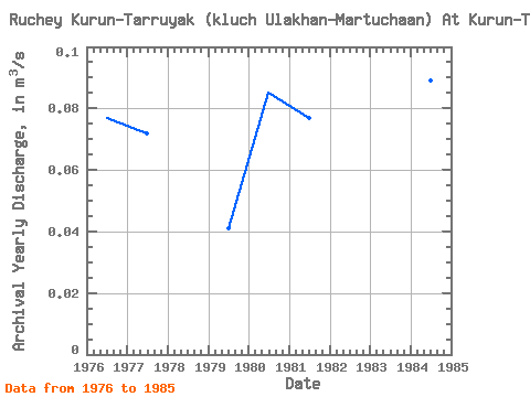
| Year | Jan | Feb | Mar | Apr | May | Jun | Jul | Aug | Sep | Oct | Nov | Dec | Annual | 1976 | 0.00 | 0.00 | 0.00 | 0.05 | 0.76 | 0.10 | 0.02 | 0.00 | 0.00 | 0.00 | 0.00 | 0.00 | 0.08 | 1977 | 0.00 | 0.00 | 0.00 | 0.00 | 0.84 | 0.01 | 0.01 | 0.00 | 0.01 | 0.00 | 0.00 | 0.00 | 0.07 | 1978 | 0.00 | 0.00 | 0.00 | 0.00 | 0.82 | 0.07 | 0.05 | 0.00 | 0.00 | 0.00 | 0.00 | 1979 | 0.00 | 0.00 | 0.00 | 0.00 | 0.45 | 0.04 | 0.00 | 0.00 | 0.00 | 0.00 | 0.00 | 0.00 | 0.04 | 1980 | 0.00 | 0.00 | 0.00 | 0.00 | 0.86 | 0.12 | 0.04 | 0.00 | 0.00 | 0.00 | 0.00 | 0.00 | 0.09 | 1981 | 0.00 | 0.00 | 0.00 | 0.00 | 0.81 | 0.10 | 0.00 | 0.01 | 0.01 | 0.00 | 0.00 | 0.00 | 0.08 | 1982 | 0.00 | 0.00 | 0.00 | 0.07 | 0.43 | 0.00 | 0.18 | 0.16 | 0.21 | 0.00 | 0.00 | 0.00 | 0.09 | 1983 | 0.00 | 0.00 | 0.00 | 0.00 | 0.93 | 0.03 | 0.00 | 0.00 | 0.00 | 0.00 | 0.00 | 0.00 | 0.08 | 1984 | 0.00 | 0.00 | 0.00 | 0.16 | 0.71 | 0.20 | 0.00 | 0.00 | 0.00 | 0.00 | 0.00 | 0.00 | 0.09 | 1985 | 0.00 | 0.00 | 0.00 | 0.00 | 0.70 | 0.05 | 0.00 | 0.00 | 0.00 | 0.00 | 0.00 | 0.00 | 0.06 | 1988 | 0.76 | 0.28 |
|---|
 Return to R-Arctic Net Home Page