|
|
|||||||||||||||||
| Point ID: 7966 | Downloads | Plots | Site Data | Code: 3606 |
|
|
|||||||||||||||||
| Download | |
|---|---|
| Site Descriptor Information | Site Time Series Data |
| Link to all available data | |
|
|
| View: | Statistics | Time Series |
| Units: | mm |
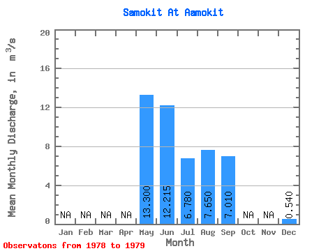
| Statistic | Jan | Feb | Mar | Apr | May | Jun | Jul | Aug | Sep | Oct | Nov | Dec | Annual |
|---|---|---|---|---|---|---|---|---|---|---|---|---|---|
| Mean | 13.30 | 12.21 | 6.78 | 7.65 | 7.01 | 0.54 | |||||||
| Standard Deviation | 0.00 | 8.18 | 3.63 | 5.59 | |||||||||
| Min | 13.30 | 6.43 | 4.21 | 3.70 | 7.01 | 0.54 | |||||||
| Max | 13.30 | 18.00 | 9.35 | 11.60 | 7.01 | 0.54 | |||||||
| Coefficient of Variation | 0.00 | 0.67 | 0.54 | 0.73 |
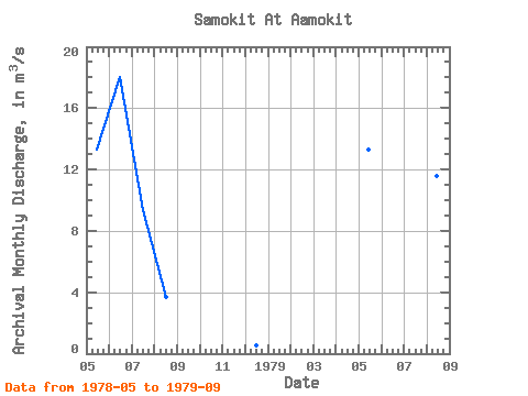
| Year | Jan | Feb | Mar | Apr | May | Jun | Jul | Aug | Sep | Oct | Nov | Dec | Annual | 1978 | 13.30 | 18.00 | 9.35 | 3.70 | 0.54 | 1979 | 13.30 | 6.43 | 4.21 | 11.60 | 7.01 |
|---|
 Return to R-Arctic Net Home Page