|
|
|||||||||||||||||
| Point ID: 794 | Downloads | Plots | Site Data | Code: 07JD002 |
|
|
|||||||||||||||||
| Download | |
|---|---|
| Site Descriptor Information | Site Time Series Data |
| Link to all available data | |
|
|
| View: | Statistics | Time Series |
| Units: | mm |
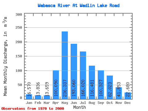
| Statistic | Jan | Feb | Mar | Apr | May | Jun | Jul | Aug | Sep | Oct | Nov | Dec | Annual |
|---|---|---|---|---|---|---|---|---|---|---|---|---|---|
| Mean | 16.57 | 13.84 | 13.66 | 100.09 | 236.34 | 193.06 | 166.02 | 116.48 | 100.33 | 82.02 | 41.85 | 22.68 | 92.85 |
| Standard Deviation | 10.86 | 8.60 | 7.72 | 84.01 | 174.51 | 169.36 | 130.80 | 101.14 | 103.34 | 86.01 | 36.01 | 15.24 | 55.56 |
| Min | 1.57 | 1.35 | 1.66 | 19.40 | 22.50 | 11.20 | 10.00 | 6.02 | 6.07 | 7.10 | 4.02 | 2.81 | 9.45 |
| Max | 44.30 | 38.00 | 31.40 | 478.00 | 726.00 | 799.00 | 567.00 | 413.00 | 391.00 | 432.00 | 160.00 | 56.40 | 248.46 |
| Coefficient of Variation | 0.66 | 0.62 | 0.57 | 0.84 | 0.74 | 0.88 | 0.79 | 0.87 | 1.03 | 1.05 | 0.86 | 0.67 | 0.60 |
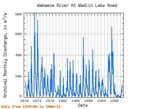
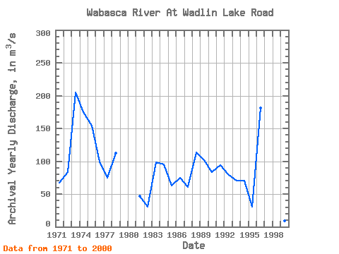
| Year | Jan | Feb | Mar | Apr | May | Jun | Jul | Aug | Sep | Oct | Nov | Dec | Annual | 1970 | 138.00 | 79.20 | 63.60 | 32.70 | 16.60 | 1971 | 10.50 | 8.80 | 9.09 | 104.00 | 123.00 | 82.80 | 239.00 | 96.60 | 60.50 | 43.10 | 20.20 | 12.30 | 67.49 | 1972 | 8.74 | 6.71 | 8.43 | 53.20 | 484.00 | 141.00 | 148.00 | 58.00 | 29.20 | 31.00 | 22.60 | 10.80 | 83.47 | 1973 | 9.64 | 8.98 | 9.16 | 90.50 | 362.00 | 799.00 | 431.00 | 264.00 | 192.00 | 156.00 | 83.80 | 48.40 | 204.54 | 1974 | 35.30 | 25.90 | 21.50 | 478.00 | 726.00 | 198.00 | 230.00 | 135.00 | 104.00 | 78.20 | 41.90 | 25.90 | 174.97 | 1975 | 18.70 | 16.30 | 15.20 | 73.80 | 237.00 | 245.00 | 268.00 | 245.00 | 380.00 | 200.00 | 106.00 | 50.40 | 154.62 | 1976 | 32.70 | 24.60 | 18.90 | 188.00 | 96.60 | 87.40 | 270.00 | 181.00 | 124.00 | 92.20 | 46.90 | 30.30 | 99.38 | 1977 | 22.60 | 22.90 | 22.90 | 71.00 | 141.00 | 215.00 | 151.00 | 70.70 | 49.90 | 72.70 | 34.70 | 18.20 | 74.38 | 1978 | 14.60 | 10.80 | 11.60 | 67.80 | 266.00 | 171.00 | 76.10 | 49.40 | 312.00 | 222.00 | 95.30 | 45.40 | 111.83 | 1979 | 24.50 | 18.70 | 11.00 | 33.80 | 415.00 | 398.00 | 192.00 | 92.10 | 76.50 | 54.00 | 1980 | 12.90 | 50.00 | 33.50 | 28.30 | 29.50 | 111.00 | 90.40 | 89.80 | 47.40 | 21.30 | 1981 | 14.90 | 11.40 | 13.40 | 113.00 | 251.00 | 71.20 | 39.30 | 18.60 | 6.86 | 10.80 | 5.77 | 3.75 | 46.66 | 1982 | 1.57 | 1.35 | 1.66 | 37.10 | 186.00 | 41.80 | 10.00 | 32.40 | 21.40 | 15.90 | 11.00 | 7.80 | 30.66 | 1983 | 6.59 | 7.17 | 7.84 | 82.40 | 92.60 | 59.10 | 252.00 | 369.00 | 145.00 | 88.00 | 45.60 | 27.30 | 98.55 | 1984 | 17.50 | 17.80 | 16.40 | 72.00 | 162.00 | 338.00 | 219.00 | 77.00 | 100.00 | 61.10 | 35.80 | 25.70 | 95.19 | 1985 | 18.30 | 14.90 | 17.50 | 104.00 | 348.00 | 86.50 | 25.80 | 17.80 | 22.80 | 52.30 | 30.40 | 14.20 | 62.71 | 1986 | 14.30 | 13.60 | 13.80 | 53.60 | 221.00 | 223.00 | 156.00 | 86.40 | 34.10 | 35.60 | 22.30 | 19.40 | 74.42 | 1987 | 12.80 | 11.70 | 10.40 | 123.00 | 115.00 | 101.00 | 31.60 | 207.00 | 53.30 | 35.40 | 22.00 | 8.69 | 60.99 | 1988 | 5.76 | 5.75 | 7.26 | 86.30 | 123.00 | 222.00 | 567.00 | 154.00 | 80.60 | 51.50 | 35.30 | 24.00 | 113.54 | 1989 | 13.90 | 10.80 | 8.71 | 54.60 | 304.00 | 235.00 | 143.00 | 152.00 | 86.70 | 119.00 | 56.90 | 38.00 | 101.88 | 1990 | 28.10 | 19.80 | 19.10 | 139.00 | 353.00 | 253.00 | 92.50 | 27.50 | 18.80 | 19.50 | 15.50 | 11.80 | 83.13 | 1991 | 7.24 | 7.08 | 7.09 | 74.90 | 87.30 | 450.00 | 219.00 | 54.60 | 89.60 | 60.80 | 40.60 | 27.40 | 93.80 | 1992 | 26.10 | 20.60 | 31.40 | 150.00 | 235.00 | 252.00 | 82.20 | 36.60 | 38.00 | 46.10 | 24.10 | 13.10 | 79.60 | 1993 | 7.16 | 6.13 | 10.90 | 36.90 | 261.00 | 103.00 | 141.00 | 99.30 | 67.20 | 61.20 | 32.10 | 23.70 | 70.80 | 1994 | 18.00 | 14.40 | 17.10 | 112.00 | 158.00 | 113.00 | 181.00 | 79.00 | 52.70 | 54.10 | 26.50 | 18.50 | 70.36 | 1995 | 16.40 | 13.00 | 11.20 | 62.70 | 93.60 | 23.90 | 22.60 | 35.70 | 33.10 | 25.20 | 16.10 | 11.90 | 30.45 | 1996 | 9.01 | 8.74 | 7.92 | 130.00 | 394.00 | 327.00 | 240.00 | 413.00 | 267.00 | 206.00 | 114.00 | 56.40 | 181.09 | 1997 | 35.60 | 29.60 | 29.10 | 189.00 | 667.00 | 426.00 | 351.00 | 219.00 | 391.00 | 432.00 | 160.00 | 52.20 | 248.46 | 1998 | 44.30 | 38.00 | 31.10 | 129.00 | 64.20 | 33.10 | 44.40 | 18.20 | 6.07 | 7.10 | 4.02 | 3.26 | 35.23 | 1999 | 2.94 | 3.29 | 5.40 | 23.70 | 22.50 | 11.20 | 10.60 | 6.02 | 10.50 | 8.51 | 5.89 | 2.81 | 9.45 | 2000 | 2.79 | 2.43 | 1.80 | 19.40 | 67.80 | 56.50 | 118.00 | 67.00 | 87.70 | 50.00 | 20.20 | 10.90 | 42.04 |
|---|
 Return to R-Arctic Net Home Page