|
|
|||||||||||||||||
| Point ID: 7935 | Downloads | Plots | Site Data | Code: 3549 |
|
|
|||||||||||||||||
| Download | |
|---|---|
| Site Descriptor Information | Site Time Series Data |
| Link to all available data | |
|
|
| View: | Statistics | Time Series |
| Units: | mm |
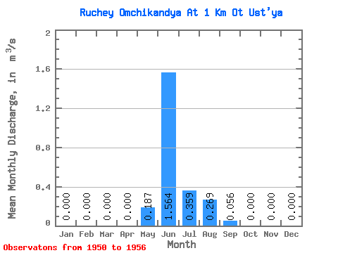
| Statistic | Jan | Feb | Mar | Apr | May | Jun | Jul | Aug | Sep | Oct | Nov | Dec | Annual |
|---|---|---|---|---|---|---|---|---|---|---|---|---|---|
| Mean | 0.00 | 0.00 | 0.00 | 0.00 | 0.19 | 1.56 | 0.36 | 0.27 | 0.06 | 0.00 | 0.00 | 0.00 | 0.20 |
| Standard Deviation | 0.00 | 0.00 | 0.00 | 0.00 | 0.42 | 0.51 | 0.35 | 0.23 | 0.04 | 0.00 | 0.00 | 0.00 | 0.08 |
| Min | 0.00 | 0.00 | 0.00 | 0.00 | 0.00 | 0.64 | 0.00 | 0.00 | 0.00 | 0.00 | 0.00 | 0.00 | 0.06 |
| Max | 0.00 | 0.00 | 0.00 | 0.00 | 1.13 | 2.32 | 0.91 | 0.56 | 0.12 | 0.00 | 0.00 | 0.00 | 0.29 |
| Coefficient of Variation | 2.25 | 0.33 | 0.96 | 0.84 | 0.75 | 0.40 |
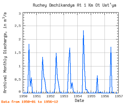
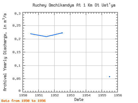
| Year | Jan | Feb | Mar | Apr | May | Jun | Jul | Aug | Sep | Oct | Nov | Dec | Annual | 1950 | 0.00 | 0.00 | 0.00 | 0.00 | 0.00 | 1.81 | 0.24 | 0.56 | 0.01 | 0.00 | 0.00 | 0.00 | 0.22 | 1951 | 0.00 | 0.00 | 0.00 | 0.00 | 0.00 | 1.33 | 0.61 | 0.46 | 0.09 | 0.00 | 0.00 | 0.00 | 0.21 | 1952 | 0.00 | 0.00 | 0.00 | 0.00 | 0.18 | 1.48 | 0.58 | 0.36 | 0.06 | 0.00 | 0.00 | 0.00 | 0.22 | 1953 | 0.00 | 0.00 | 0.00 | 0.00 | 1.13 | 1.67 | 0.16 | 0.38 | 0.07 | 0.00 | 0.00 | 0.00 | 0.28 | 1954 | 0.00 | 0.00 | 0.00 | 0.00 | 0.00 | 2.32 | 0.91 | 0.11 | 0.12 | 0.00 | 0.00 | 0.00 | 0.29 | 1955 | 0.00 | 0.00 | 0.00 | 0.00 | 0.00 | 0.64 | 0.00 | 0.00 | 0.04 | 0.00 | 0.00 | 0.00 | 0.06 | 1956 | 0.00 | 0.00 | 0.00 | 0.00 | 0.00 | 1.70 | 0.01 | 0.01 | 0.00 | 0.00 | 0.00 | 0.00 | 0.14 |
|---|
 Return to R-Arctic Net Home Page