|
|
|||||||||||||||||
| Point ID: 7914 | Downloads | Plots | Site Data | Code: 3450 |
|
|
|||||||||||||||||
| Download | |
|---|---|
| Site Descriptor Information | Site Time Series Data |
| Link to all available data | |
|
|
| View: | Statistics | Time Series |
| Units: | mm |
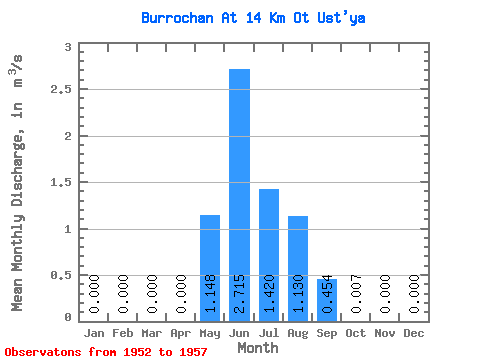
| Statistic | Jan | Feb | Mar | Apr | May | Jun | Jul | Aug | Sep | Oct | Nov | Dec | Annual |
|---|---|---|---|---|---|---|---|---|---|---|---|---|---|
| Mean | 0.00 | 0.00 | 0.00 | 0.00 | 1.15 | 2.71 | 1.42 | 1.13 | 0.45 | 0.01 | 0.00 | 0.00 | 0.56 |
| Standard Deviation | 0.00 | 0.00 | 0.00 | 0.00 | 0.80 | 1.12 | 0.76 | 0.53 | 0.49 | 0.00 | 0.00 | 0.00 | 0.15 |
| Min | 0.00 | 0.00 | 0.00 | 0.00 | 0.25 | 1.04 | 0.30 | 0.47 | 0.10 | 0.00 | 0.00 | 0.00 | 0.38 |
| Max | 0.00 | 0.00 | 0.00 | 0.00 | 2.26 | 4.09 | 2.33 | 1.68 | 1.29 | 0.01 | 0.00 | 0.00 | 0.76 |
| Coefficient of Variation | 0.70 | 0.41 | 0.53 | 0.47 | 1.08 | 0.51 | 0.27 |
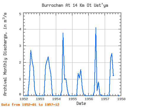
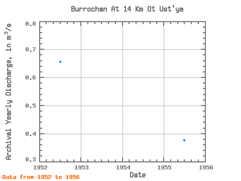
| Year | Jan | Feb | Mar | Apr | May | Jun | Jul | Aug | Sep | Oct | Nov | Dec | Annual | 1952 | 0.00 | 0.00 | 0.00 | 0.00 | 0.95 | 2.74 | 2.13 | 1.68 | 0.35 | 0.01 | 0.00 | 0.00 | 0.66 | 1953 | 0.00 | 0.00 | 0.00 | 0.00 | 1.78 | 2.10 | 2.33 | 1.66 | 1.29 | 0.01 | 0.00 | 0.00 | 0.76 | 1954 | 0.00 | 0.00 | 0.00 | 0.00 | 0.32 | 3.78 | 0.98 | 1.02 | 0.43 | 0.01 | 0.00 | 0.00 | 0.55 | 1955 | 0.00 | 0.00 | 0.00 | 0.00 | 1.33 | 1.04 | 1.57 | 0.47 | 0.10 | 0.00 | 0.00 | 0.00 | 0.38 | 1956 | 0.00 | 0.00 | 0.00 | 0.00 | 0.25 | 4.09 | 0.30 | 0.82 | 0.10 | 0.01 | 0.00 | 0.00 | 0.46 | 1957 | 0.00 | 0.00 | 0.00 | 0.00 | 2.26 | 2.54 | 1.21 | 0.00 | 0.00 |
|---|
 Return to R-Arctic Net Home Page