|
|
|||||||||||||||||
| Point ID: 7905 | Downloads | Plots | Site Data | Code: 3412 |
|
|
|||||||||||||||||
| Download | |
|---|---|
| Site Descriptor Information | Site Time Series Data |
| Link to all available data | |
|
|
| View: | Statistics | Time Series |
| Units: | mm |
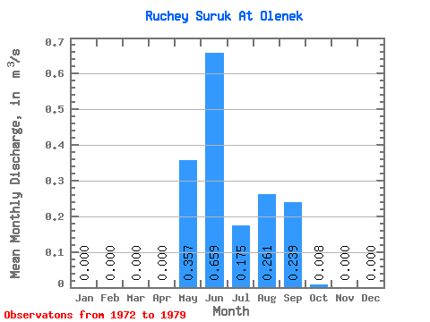
| Statistic | Jan | Feb | Mar | Apr | May | Jun | Jul | Aug | Sep | Oct | Nov | Dec | Annual |
|---|---|---|---|---|---|---|---|---|---|---|---|---|---|
| Mean | 0.00 | 0.00 | 0.00 | 0.00 | 0.36 | 0.66 | 0.17 | 0.26 | 0.24 | 0.01 | 0.00 | 0.00 | 0.14 |
| Standard Deviation | 0.00 | 0.00 | 0.00 | 0.00 | 0.31 | 0.51 | 0.25 | 0.47 | 0.27 | 0.01 | 0.00 | 0.00 | 0.09 |
| Min | 0.00 | 0.00 | 0.00 | 0.00 | 0.01 | 0.33 | 0.00 | 0.00 | 0.00 | 0.00 | 0.00 | 0.00 | 0.04 |
| Max | 0.00 | 0.00 | 0.00 | 0.00 | 0.87 | 1.77 | 0.63 | 1.30 | 0.64 | 0.02 | 0.00 | 0.00 | 0.27 |
| Coefficient of Variation | 0.86 | 0.78 | 1.40 | 1.79 | 1.13 | 0.85 | 2.65 | 0.60 |
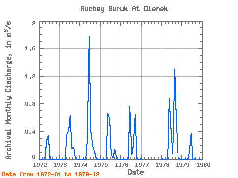
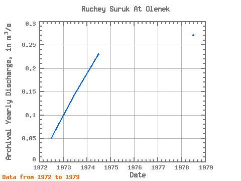
| Year | Jan | Feb | Mar | Apr | May | Jun | Jul | Aug | Sep | Oct | Nov | Dec | Annual | 1972 | 0.00 | 0.00 | 0.00 | 0.00 | 0.27 | 0.33 | 0.00 | 0.00 | 0.00 | 0.00 | 0.00 | 0.00 | 0.05 | 1973 | 0.00 | 0.00 | 0.00 | 0.00 | 0.35 | 0.42 | 0.63 | 0.15 | 0.17 | 0.02 | 0.00 | 0.00 | 0.14 | 1974 | 0.00 | 0.00 | 0.00 | 0.00 | 0.26 | 1.77 | 0.41 | 0.18 | 0.12 | 0.01 | 0.00 | 0.00 | 0.23 | 1975 | 0.00 | 0.00 | 0.00 | 0.00 | 0.66 | 0.58 | 0.05 | 0.02 | 0.14 | 0.00 | 0.00 | 0.00 | 0.12 | 1976 | 0.00 | 0.00 | 0.00 | 0.00 | 0.01 | 0.76 | 0.06 | 0.18 | 0.64 | 0.01 | 0.00 | 0.00 | 0.14 | 1978 | 0.00 | 0.00 | 0.00 | 0.00 | 0.87 | 0.38 | 0.07 | 1.30 | 0.60 | 0.01 | 0.00 | 0.00 | 0.27 | 1979 | 0.00 | 0.00 | 0.00 | 0.00 | 0.09 | 0.37 | 0.00 | 0.00 | 0.00 | 0.00 | 0.00 | 0.00 | 0.04 |
|---|
 Return to R-Arctic Net Home Page