|
|
|||||||||||||||||
| Point ID: 7880 | Downloads | Plots | Site Data | Code: 3352 |
|
|
|||||||||||||||||
| Download | |
|---|---|
| Site Descriptor Information | Site Time Series Data |
| Link to all available data | |
|
|
| View: | Statistics | Time Series |
| Units: | mm |
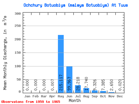
| Statistic | Jan | Feb | Mar | Apr | May | Jun | Jul | Aug | Sep | Oct | Nov | Dec | Annual |
|---|---|---|---|---|---|---|---|---|---|---|---|---|---|
| Mean | 0.00 | 0.00 | 0.00 | 0.01 | 215.12 | 99.97 | 28.22 | 17.74 | 9.33 | 7.38 | 2.65 | 0.02 | 34.54 |
| Standard Deviation | 0.00 | 0.00 | 0.00 | 0.01 | 96.19 | 51.34 | 34.54 | 31.29 | 9.08 | 6.14 | 2.32 | 0.04 | 17.78 |
| Min | 0.00 | 0.00 | 0.00 | 0.00 | 84.70 | 29.70 | 4.48 | 0.86 | 0.49 | 0.24 | 0.01 | 0.00 | 10.34 |
| Max | 0.00 | 0.00 | 0.00 | 0.03 | 322.00 | 179.00 | 94.80 | 73.60 | 20.10 | 12.80 | 4.85 | 0.08 | 49.80 |
| Coefficient of Variation | 1.59 | 0.45 | 0.51 | 1.22 | 1.76 | 0.97 | 0.83 | 0.87 | 2.00 | 0.52 |
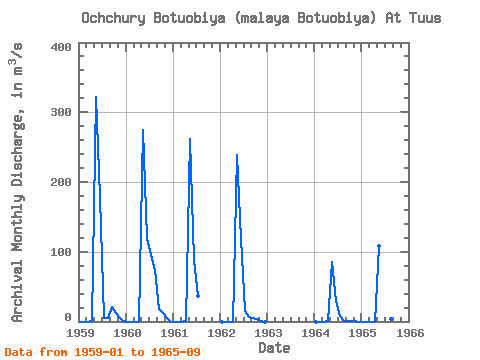
| Year | Jan | Feb | Mar | Apr | May | Jun | Jul | Aug | Sep | Oct | Nov | Dec | Annual | 1959 | 0.00 | 0.00 | 0.00 | 0.01 | 322.00 | 179.00 | 4.48 | 5.57 | 20.10 | 12.20 | 4.85 | 0.08 | 45.69 | 1960 | 0.00 | 0.00 | 0.00 | 0.00 | 275.00 | 119.00 | 94.80 | 73.60 | 18.10 | 12.80 | 4.32 | 0.00 | 49.80 | 1961 | 0.00 | 0.00 | 0.00 | 0.03 | 262.00 | 88.40 | 36.60 | 1962 | 0.00 | 0.00 | 0.00 | 0.00 | 239.00 | 118.00 | 14.80 | 5.74 | 4.74 | 4.30 | 1.42 | 0.00 | 32.33 | 1964 | 0.00 | 0.00 | 0.00 | 0.01 | 84.70 | 29.70 | 8.03 | 0.86 | 0.49 | 0.24 | 0.01 | 0.00 | 10.34 | 1965 | 0.00 | 0.00 | 0.00 | 0.00 | 108.00 | 65.70 | 10.60 | 2.93 | 3.20 |
|---|
 Return to R-Arctic Net Home Page