|
|
|||||||||||||||||
| Point ID: 7873 | Downloads | Plots | Site Data | Code: 3342 |
|
|
|||||||||||||||||
| Download | |
|---|---|
| Site Descriptor Information | Site Time Series Data |
| Link to all available data | |

|
|
| View: | Statistics | Time Series |
| Units: | mm |
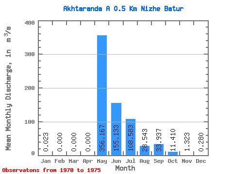
| Statistic | Jan | Feb | Mar | Apr | May | Jun | Jul | Aug | Sep | Oct | Nov | Dec | Annual |
|---|---|---|---|---|---|---|---|---|---|---|---|---|---|
| Mean | 0.02 | 0.00 | 0.00 | 0.00 | 356.17 | 155.13 | 108.58 | 28.54 | 33.94 | 11.41 | 1.32 | 0.28 | 57.95 |
| Standard Deviation | 0.05 | 0.00 | 0.00 | 0.00 | 65.14 | 81.09 | 140.55 | 45.39 | 55.59 | 9.92 | 0.80 | 0.27 | 22.01 |
| Min | 0.00 | 0.00 | 0.00 | 0.00 | 287.00 | 89.60 | 13.40 | 2.26 | 2.94 | 2.31 | 0.41 | 0.00 | 35.43 |
| Max | 0.12 | 0.00 | 0.00 | 0.00 | 465.00 | 304.00 | 312.00 | 118.00 | 146.00 | 29.70 | 2.66 | 0.74 | 92.79 |
| Coefficient of Variation | 2.08 | 0.18 | 0.52 | 1.29 | 1.59 | 1.64 | 0.87 | 0.61 | 0.97 | 0.38 |
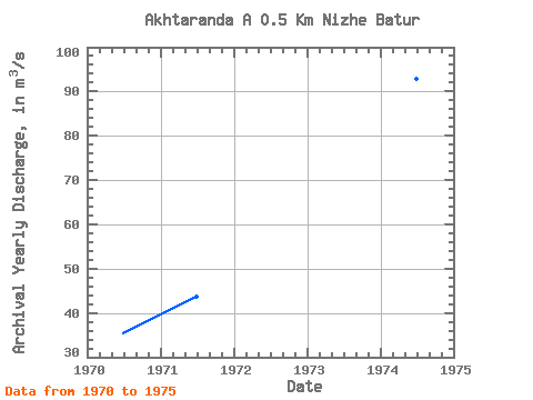
| Year | Jan | Feb | Mar | Apr | May | Jun | Jul | Aug | Sep | Oct | Nov | Dec | Annual | 1970 | 0.00 | 0.00 | 0.00 | 0.00 | 287.00 | 98.20 | 24.30 | 7.71 | 4.54 | 2.75 | 0.58 | 0.08 | 35.43 | 1971 | 0.00 | 0.00 | 0.00 | 0.00 | 364.00 | 103.00 | 18.20 | 6.81 | 19.00 | 11.40 | 1.51 | 0.74 | 43.72 | 1972 | 0.12 | 0.00 | 0.00 | 0.00 | 303.00 | 160.00 | 13.40 | 2.26 | 2.94 | 2.31 | 0.41 | 0.00 | 40.37 | 1973 | 0.00 | 0.00 | 0.00 | 0.00 | 388.00 | 89.60 | 266.00 | 33.90 | 24.80 | 11.10 | 2.66 | 0.42 | 68.04 | 1974 | 0.02 | 0.00 | 0.00 | 0.00 | 330.00 | 176.00 | 312.00 | 118.00 | 146.00 | 29.70 | 1.43 | 0.28 | 92.79 | 1975 | 0.00 | 0.00 | 0.00 | 0.00 | 465.00 | 304.00 | 17.60 | 2.58 | 6.34 | 11.20 | 1.35 | 0.16 | 67.35 |
|---|
 Return to R-Arctic Net Home Page