|
|
|||||||||||||||||
| Point ID: 7867 | Downloads | Plots | Site Data | Code: 3336 |
|
|
|||||||||||||||||
| Download | |
|---|---|
| Site Descriptor Information | Site Time Series Data |
| Link to all available data | |
|
|
| View: | Statistics | Time Series |
| Units: | mm |
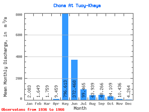
| Statistic | Jan | Feb | Mar | Apr | May | Jun | Jul | Aug | Sep | Oct | Nov | Dec | Annual |
|---|---|---|---|---|---|---|---|---|---|---|---|---|---|
| Mean | 2.08 | 1.65 | 1.76 | 9.46 | 796.61 | 372.47 | 99.47 | 43.94 | 48.27 | 34.11 | 10.44 | 4.26 | 118.71 |
| Standard Deviation | 0.88 | 0.76 | 1.17 | 27.28 | 282.65 | 268.77 | 68.39 | 43.18 | 37.88 | 21.49 | 5.88 | 2.47 | 38.28 |
| Min | 0.21 | 0.05 | 0.38 | 0.36 | 324.00 | 85.40 | 28.80 | 13.50 | 8.75 | 6.02 | 3.19 | 1.62 | 47.97 |
| Max | 4.64 | 3.63 | 6.08 | 150.00 | 1360.00 | 1440.00 | 292.00 | 236.00 | 150.00 | 91.90 | 33.10 | 13.80 | 192.02 |
| Coefficient of Variation | 0.42 | 0.46 | 0.66 | 2.88 | 0.35 | 0.72 | 0.69 | 0.98 | 0.79 | 0.63 | 0.56 | 0.58 | 0.32 |
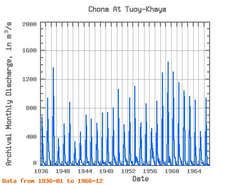
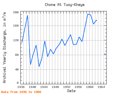
| Year | Jan | Feb | Mar | Apr | May | Jun | Jul | Aug | Sep | Oct | Nov | Dec | Annual | 1936 | 3.09 | 2.48 | 2.46 | 2.67 | 669.00 | 385.00 | 196.00 | 40.60 | 34.10 | 18.00 | 10.00 | 3.58 | 113.92 | 1937 | 2.31 | 1.97 | 1.93 | 2.00 | 936.00 | 353.00 | 292.00 | 92.00 | 74.40 | 54.20 | 11.00 | 2.57 | 151.95 | 1938 | 1.20 | 1.21 | 1.70 | 7.00 | 1360.00 | 568.00 | 248.00 | 14.60 | 11.70 | 26.00 | 11.50 | 3.30 | 187.85 | 1939 | 2.11 | 1.75 | 1.71 | 16.30 | 370.00 | 150.00 | 40.50 | 16.90 | 18.80 | 10.80 | 5.44 | 3.45 | 53.15 | 1940 | 2.54 | 2.28 | 2.36 | 2.26 | 579.00 | 250.00 | 36.20 | 26.90 | 42.60 | 35.60 | 9.14 | 3.16 | 82.67 | 1941 | 1.94 | 1.14 | 0.87 | 0.98 | 880.00 | 271.00 | 50.00 | 25.40 | 19.20 | 16.50 | 7.75 | 2.46 | 106.44 | 1942 | 1.78 | 1.77 | 1.76 | 1.85 | 324.00 | 141.00 | 36.70 | 21.40 | 22.00 | 14.00 | 6.73 | 2.66 | 47.97 | 1943 | 1.62 | 1.38 | 1.21 | 150.00 | 464.00 | 85.40 | 53.00 | 30.90 | 26.40 | 25.10 | 9.10 | 2.82 | 70.91 | 1944 | 1.31 | 1.07 | 0.82 | 0.68 | 702.00 | 400.00 | 174.00 | 28.90 | 36.00 | 47.50 | 16.40 | 3.52 | 117.68 | 1945 | 1.74 | 1.10 | 1.11 | 2.14 | 640.00 | 148.00 | 47.00 | 13.50 | 22.40 | 11.70 | 5.80 | 2.21 | 74.72 | 1946 | 1.29 | 1.32 | 1.81 | 1.83 | 583.00 | 375.00 | 53.60 | 27.80 | 44.50 | 33.40 | 10.30 | 4.05 | 94.83 | 1947 | 1.05 | 1.16 | 1.29 | 42.60 | 730.00 | 88.10 | 28.80 | 18.60 | 37.40 | 33.00 | 7.93 | 3.85 | 82.81 | 1948 | 1.78 | 0.87 | 0.77 | 0.81 | 736.00 | 290.00 | 45.10 | 23.00 | 38.30 | 26.00 | 9.20 | 4.21 | 98.00 | 1949 | 2.03 | 1.23 | 1.35 | 2.02 | 801.00 | 170.00 | 93.80 | 40.30 | 110.00 | 58.10 | 11.00 | 6.73 | 108.13 | 1950 | 3.06 | 2.04 | 2.17 | 2.62 | 1060.00 | 248.00 | 90.50 | 34.30 | 14.90 | 9.35 | 3.19 | 2.17 | 122.69 | 1951 | 1.51 | 1.30 | 1.16 | 1.64 | 562.00 | 346.00 | 140.00 | 50.70 | 91.40 | 56.40 | 10.40 | 6.21 | 105.73 | 1952 | 3.13 | 1.60 | 1.87 | 2.39 | 935.00 | 255.00 | 67.60 | 84.70 | 30.20 | 49.60 | 13.40 | 6.12 | 120.88 | 1953 | 3.00 | 1.65 | 0.72 | 16.50 | 1100.00 | 199.00 | 42.80 | 67.60 | 113.00 | 52.40 | 15.90 | 9.06 | 135.14 | 1954 | 2.90 | 1.50 | 1.11 | 1.80 | 470.00 | 593.00 | 154.00 | 29.20 | 12.40 | 18.90 | 6.38 | 4.12 | 107.94 | 1955 | 1.75 | 1.25 | 0.38 | 0.36 | 855.00 | 350.00 | 50.90 | 19.20 | 8.75 | 6.02 | 6.25 | 3.69 | 108.63 | 1956 | 0.21 | 0.05 | 0.54 | 0.81 | 422.00 | 512.00 | 97.20 | 236.00 | 150.00 | 83.80 | 33.10 | 7.65 | 128.61 | 1957 | 1.78 | 0.95 | 1.20 | 2.13 | 894.00 | 237.00 | 63.50 | 53.00 | 30.90 | 91.90 | 21.80 | 3.76 | 116.83 | 1958 | 1.08 | 3.15 | 6.08 | 5.17 | 1290.00 | 352.00 | 87.60 | 21.30 | 36.30 | 21.20 | 15.70 | 13.80 | 154.45 | 1959 | 1.84 | 1.70 | 2.22 | 5.07 | 578.00 | 1440.00 | 41.00 | 44.10 | 116.00 | 54.80 | 13.60 | 5.87 | 192.02 | 1960 | 2.95 | 1.29 | 1.58 | 1.85 | 1300.00 | 580.00 | 137.00 | 95.40 | 101.00 | 37.50 | 10.20 | 3.66 | 189.37 | 1961 | 2.65 | 2.06 | 2.13 | 5.13 | 1150.00 | 425.00 | 145.00 | 94.00 | 90.90 | 47.20 | 8.90 | 3.75 | 164.73 | 1962 | 2.10 | 3.63 | 4.23 | 4.24 | 1037.00 | 878.00 | 100.00 | 18.00 | 24.80 | 15.20 | 4.56 | 2.17 | 174.49 | 1963 | 2.76 | 2.69 | 3.42 | 4.87 | 955.00 | 691.00 | 76.80 | 27.70 | 64.30 | 40.70 | 12.30 | 4.83 | 157.20 | 1964 | 4.64 | 3.07 | 2.63 | 3.02 | 910.00 | 280.00 | 224.00 | 21.40 | 12.10 | 9.52 | 4.52 | 2.87 | 123.15 | 1965 | 2.57 | 1.61 | 1.53 | 1.75 | 470.00 | 297.00 | 112.00 | 24.00 | 31.70 | 31.60 | 6.28 | 2.27 | 81.86 | 1966 | 0.85 | 0.83 | 0.40 | 0.72 | 933.00 | 189.00 | 58.80 | 20.70 | 29.80 | 21.40 | 5.75 | 1.62 | 105.24 |
|---|
 Return to R-Arctic Net Home Page