|
|
|||||||||||||||||
| Point ID: 7832 | Downloads | Plots | Site Data | Code: 3203 |
|
|
|||||||||||||||||
| Download | |
|---|---|
| Site Descriptor Information | Site Time Series Data |
| Link to all available data | |
|
|
| View: | Statistics | Time Series |
| Units: | mm |
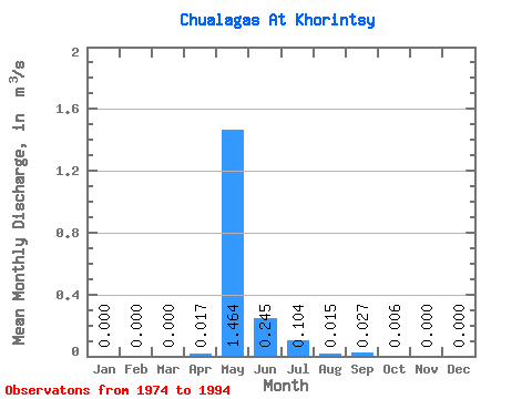
| Statistic | Jan | Feb | Mar | Apr | May | Jun | Jul | Aug | Sep | Oct | Nov | Dec | Annual |
|---|---|---|---|---|---|---|---|---|---|---|---|---|---|
| Mean | 0.00 | 0.00 | 0.00 | 0.02 | 1.46 | 0.24 | 0.10 | 0.01 | 0.03 | 0.01 | 0.00 | 0.00 | 0.17 |
| Standard Deviation | 0.00 | 0.00 | 0.00 | 0.03 | 0.73 | 0.28 | 0.20 | 0.03 | 0.05 | 0.01 | 0.00 | 0.00 | 0.09 |
| Min | 0.00 | 0.00 | 0.00 | 0.00 | 0.36 | 0.00 | 0.00 | 0.00 | 0.00 | 0.00 | 0.00 | 0.00 | 0.04 |
| Max | 0.00 | 0.00 | 0.00 | 0.10 | 2.58 | 0.85 | 0.85 | 0.07 | 0.19 | 0.06 | 0.00 | 0.00 | 0.31 |
| Coefficient of Variation | 1.70 | 0.50 | 1.14 | 1.98 | 1.68 | 1.80 | 2.66 | 0.54 |
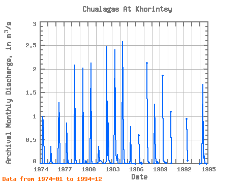
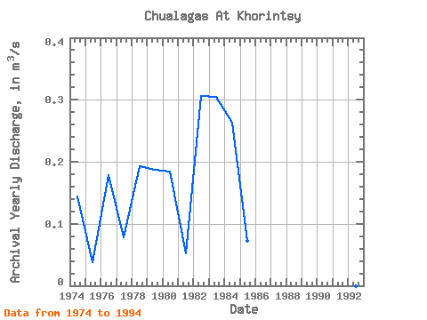
| Year | Jan | Feb | Mar | Apr | May | Jun | Jul | Aug | Sep | Oct | Nov | Dec | Annual | 1974 | 0.00 | 0.00 | 0.00 | 0.00 | 1.00 | 0.70 | 0.03 | 0.00 | 0.00 | 0.00 | 0.00 | 0.00 | 0.14 | 1975 | 0.00 | 0.00 | 0.00 | 0.04 | 0.36 | 0.06 | 0.00 | 0.00 | 0.00 | 0.00 | 0.00 | 0.00 | 0.04 | 1976 | 0.00 | 0.00 | 0.00 | 0.00 | 1.28 | 0.85 | 0.01 | 0.00 | 0.00 | 0.00 | 0.00 | 0.00 | 0.18 | 1977 | 0.00 | 0.00 | 0.00 | 0.00 | 0.85 | 0.02 | 0.07 | 0.00 | 0.00 | 0.00 | 0.00 | 0.00 | 0.08 | 1978 | 0.00 | 0.00 | 0.00 | 0.01 | 2.08 | 0.23 | 0.00 | 0.00 | 0.00 | 0.00 | 0.00 | 0.00 | 0.19 | 1979 | 0.00 | 0.00 | 0.00 | 0.00 | 2.02 | 0.14 | 0.00 | 0.00 | 0.01 | 0.06 | 0.00 | 0.00 | 0.19 | 1980 | 0.00 | 0.00 | 0.00 | 0.00 | 2.12 | 0.09 | 0.00 | 0.00 | 0.00 | 0.00 | 0.00 | 0.00 | 0.18 | 1981 | 0.00 | 0.00 | 0.00 | 0.04 | 0.36 | 0.05 | 0.06 | 0.06 | 0.05 | 0.00 | 0.00 | 0.00 | 0.05 | 1982 | 0.00 | 0.00 | 0.00 | 0.05 | 2.47 | 0.17 | 0.85 | 0.07 | 0.06 | 0.00 | 0.00 | 0.00 | 0.31 | 1983 | 0.00 | 0.00 | 0.00 | 0.00 | 2.40 | 0.79 | 0.19 | 0.06 | 0.19 | 0.01 | 0.00 | 0.00 | 0.30 | 1984 | 0.00 | 0.00 | 0.00 | 0.00 | 2.58 | 0.39 | 0.18 | 0.00 | 0.00 | 0.00 | 0.00 | 0.00 | 0.26 | 1985 | 0.00 | 0.00 | 0.00 | 0.10 | 0.78 | 0.00 | 0.00 | 0.00 | 0.00 | 0.00 | 0.00 | 0.00 | 0.07 | 1986 | 0.60 | 0.22 | 0.00 | 0.02 | 0.00 | 1987 | 2.12 | 0.61 | 0.04 | 0.02 | 1988 | 0.01 | 1.25 | 0.12 | 0.07 | 0.00 | 0.04 | 0.00 | 1989 | 1.85 | 0.06 | 0.04 | 0.02 | 0.03 | 0.00 | 1990 | 1.09 | 0.00 | 1992 | 0.94 | 0.06 | 1994 | 0.00 | 0.00 | 0.00 | 0.00 | 1.67 | 0.11 | 0.21 | 0.01 | 0.03 | 0.01 | 0.00 | 0.00 | 0.17 |
|---|
 Return to R-Arctic Net Home Page