|
|
|||||||||||||||||
| Point ID: 7787 | Downloads | Plots | Site Data | Code: 3017 |
|
|
|||||||||||||||||
| Download | |
|---|---|
| Site Descriptor Information | Site Time Series Data |
| Link to all available data | |
|
|
| View: | Statistics | Time Series |
| Units: | mm |
| Statistic | Jan | Feb | Mar | Apr | May | Jun | Jul | Aug | Sep | Oct | Nov | Dec | Annual |
|---|---|---|---|---|---|---|---|---|---|---|---|---|---|
| Mean | 155.72 | 131.38 | 120.24 | 186.59 | 1760.00 | 956.39 | 610.00 | 535.28 | 467.89 | 326.28 | 189.94 | 190.00 | 469.14 |
| Standard Deviation | 43.78 | 37.51 | 34.12 | 124.29 | 389.63 | 308.93 | 276.89 | 240.79 | 170.07 | 121.28 | 56.34 | 54.65 | 97.08 |
| Min | 105.00 | 85.90 | 81.80 | 94.70 | 1050.00 | 381.00 | 282.00 | 267.00 | 259.00 | 180.00 | 124.00 | 122.00 | 362.02 |
| Max | 276.00 | 241.00 | 217.00 | 663.00 | 2320.00 | 1570.00 | 1220.00 | 1040.00 | 835.00 | 650.00 | 309.00 | 324.00 | 708.58 |
| Coefficient of Variation | 0.28 | 0.28 | 0.28 | 0.67 | 0.22 | 0.32 | 0.45 | 0.45 | 0.36 | 0.37 | 0.30 | 0.29 | 0.21 |
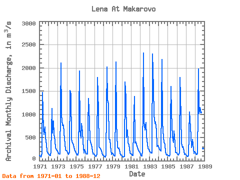
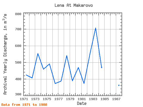
| Year | Jan | Feb | Mar | Apr | May | Jun | Jul | Aug | Sep | Oct | Nov | Dec | Annual | 1971 | 116.00 | 104.00 | 81.80 | 159.00 | 1470.00 | 667.00 | 561.00 | 727.00 | 497.00 | 349.00 | 214.00 | 155.00 | 425.07 | 1972 | 133.00 | 120.00 | 115.00 | 214.00 | 1120.00 | 593.00 | 854.00 | 569.00 | 433.00 | 277.00 | 231.00 | 216.00 | 406.25 | 1973 | 187.00 | 153.00 | 142.00 | 144.00 | 2100.00 | 975.00 | 753.00 | 772.00 | 599.00 | 360.00 | 232.00 | 219.00 | 553.00 | 1974 | 198.00 | 151.00 | 133.00 | 174.00 | 1510.00 | 1420.00 | 457.00 | 380.00 | 368.00 | 294.00 | 235.00 | 188.00 | 459.00 | 1975 | 158.00 | 122.00 | 120.00 | 192.00 | 1930.00 | 648.00 | 485.00 | 798.00 | 622.00 | 405.00 | 171.00 | 240.00 | 490.92 | 1976 | 191.00 | 158.00 | 143.00 | 149.00 | 1340.00 | 839.00 | 441.00 | 360.00 | 349.00 | 211.00 | 149.00 | 148.00 | 373.17 | 1977 | 128.00 | 102.00 | 94.10 | 146.00 | 1790.00 | 1090.00 | 297.00 | 275.00 | 259.00 | 210.00 | 127.00 | 122.00 | 386.68 | 1978 | 107.00 | 92.00 | 82.50 | 134.00 | 2020.00 | 1310.00 | 1220.00 | 465.00 | 454.00 | 303.00 | 137.00 | 168.00 | 541.04 | 1979 | 152.00 | 123.00 | 101.00 | 105.00 | 2120.00 | 807.00 | 282.00 | 267.00 | 275.00 | 180.00 | 124.00 | 129.00 | 388.75 | 1980 | 105.00 | 85.90 | 82.80 | 94.70 | 1690.00 | 1360.00 | 504.00 | 660.00 | 390.00 | 335.00 | 167.00 | 157.00 | 469.28 | 1981 | 142.00 | 125.00 | 112.00 | 663.00 | 1380.00 | 381.00 | 399.00 | 346.00 | 287.00 | 257.00 | 194.00 | 191.00 | 373.08 | 1982 | 145.00 | 113.00 | 103.00 | 223.00 | 2320.00 | 849.00 | 666.00 | 820.00 | 520.00 | 364.00 | 267.00 | 238.00 | 552.33 | 1983 | 204.00 | 183.00 | 170.00 | 172.00 | 2300.00 | 1570.00 | 985.00 | 801.00 | 835.00 | 650.00 | 309.00 | 324.00 | 708.58 | 1984 | 276.00 | 241.00 | 217.00 | 210.00 | 2180.00 | 818.00 | 496.00 | 389.00 | 350.00 | 193.00 | 127.00 | 130.00 | 468.92 | 1985 | 115.00 | 108.00 | 107.00 | 129.00 | 1600.00 | 1030.00 | 514.00 | 393.00 | 638.00 | 395.00 | 173.00 | 174.00 | 448.00 | 1986 | 157.00 | 139.00 | 129.00 | 162.00 | 1790.00 | 963.00 | 368.00 | 285.00 | 310.00 | 211.00 | 135.00 | 146.00 | 399.58 | 1987 | 115.00 | 100.00 | 96.20 | 116.00 | 1050.00 | 875.00 | 548.00 | 288.00 | 453.00 | 346.00 | 160.00 | 197.00 | 362.02 | 1988 | 174.00 | 145.00 | 135.00 | 172.00 | 1970.00 | 1020.00 | 1150.00 | 1040.00 | 783.00 | 533.00 | 267.00 | 278.00 | 638.92 |
|---|
 Return to R-Arctic Net Home Page
