|
|
|||||||||||||||||
| Point ID: 7782 | Downloads | Plots | Site Data | Code: 70617 |
|
|
|||||||||||||||||
| Download | |
|---|---|
| Site Descriptor Information | Site Time Series Data |
| Link to all available data | |
|
|
| View: | Statistics | Time Series |
| Units: | mm |
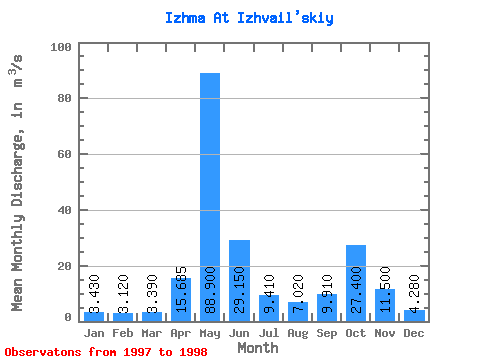
| Statistic | Jan | Feb | Mar | Apr | May | Jun | Jul | Aug | Sep | Oct | Nov | Dec | Annual |
|---|---|---|---|---|---|---|---|---|---|---|---|---|---|
| Mean | 3.43 | 3.12 | 3.39 | 15.69 | 88.90 | 29.15 | 9.41 | 7.02 | 9.91 | 27.40 | 11.50 | 4.28 | 17.77 |
| Standard Deviation | 0.07 | 0.11 | 0.26 | 15.86 | 3.96 | 11.24 | 3.95 | 2.87 | 2.39 | 0.42 | 0.57 | 0.20 | 0.47 |
| Min | 3.38 | 3.04 | 3.21 | 4.47 | 86.10 | 21.20 | 6.62 | 4.99 | 8.22 | 27.10 | 11.10 | 4.14 | 17.43 |
| Max | 3.48 | 3.20 | 3.57 | 26.90 | 91.70 | 37.10 | 12.20 | 9.05 | 11.60 | 27.70 | 11.90 | 4.42 | 18.10 |
| Coefficient of Variation | 0.02 | 0.04 | 0.07 | 1.01 | 0.04 | 0.39 | 0.42 | 0.41 | 0.24 | 0.01 | 0.05 | 0.05 | 0.03 |
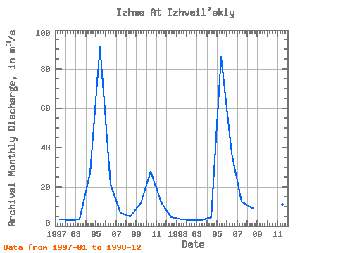
| Year | Jan | Feb | Mar | Apr | May | Jun | Jul | Aug | Sep | Oct | Nov | Dec | Annual | 1997 | 3.38 | 3.20 | 3.57 | 26.90 | 91.70 | 21.20 | 6.62 | 4.99 | 11.60 | 27.70 | 11.90 | 4.42 | 18.10 | 1998 | 3.48 | 3.04 | 3.21 | 4.47 | 86.10 | 37.10 | 12.20 | 9.05 | 8.22 | 27.10 | 11.10 | 4.14 | 17.43 |
|---|
 Return to R-Arctic Net Home Page