|
|
|||||||||||||||||
| Point ID: 7778 | Downloads | Plots | Site Data | Code: 10QB001 |
|
|
|||||||||||||||||
| Download | |
|---|---|
| Site Descriptor Information | Site Time Series Data |
| Link to all available data | |
|
|
| View: | Statistics | Time Series |
| Units: | mm |
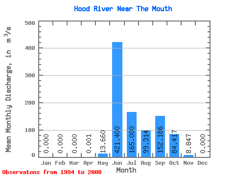
| Statistic | Jan | Feb | Mar | Apr | May | Jun | Jul | Aug | Sep | Oct | Nov | Dec | Annual |
|---|---|---|---|---|---|---|---|---|---|---|---|---|---|
| Mean | 0.00 | 0.00 | 0.00 | 0.00 | 13.66 | 421.40 | 165.00 | 99.31 | 152.19 | 84.42 | 8.85 | 0.00 | 77.80 |
| Standard Deviation | 0.00 | 0.00 | 0.00 | 0.00 | 14.60 | 111.56 | 43.19 | 33.01 | 62.36 | 57.00 | 5.22 | 0.00 | 29.84 |
| Min | 0.00 | 0.00 | 0.00 | 0.00 | 1.94 | 318.00 | 101.00 | 54.90 | 68.90 | 29.40 | 2.54 | 0.00 | 56.75 |
| Max | 0.00 | 0.00 | 0.00 | 0.01 | 32.40 | 606.00 | 222.00 | 139.00 | 243.00 | 183.00 | 13.80 | 0.00 | 111.96 |
| Coefficient of Variation | 2.00 | 1.07 | 0.27 | 0.26 | 0.33 | 0.41 | 0.68 | 0.59 | 0.38 |
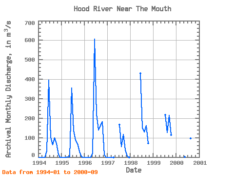
| Year | Jan | Feb | Mar | Apr | May | Jun | Jul | Aug | Sep | Oct | Nov | Dec | Annual | 1994 | 0.00 | 0.00 | 0.00 | 0.00 | 32.40 | 396.00 | 101.00 | 64.60 | 98.40 | 70.20 | 13.80 | 0.00 | 64.70 | 1995 | 0.00 | 0.00 | 0.00 | 0.01 | 2.20 | 356.00 | 136.00 | 86.00 | 68.90 | 29.40 | 2.54 | 0.00 | 56.75 | 1996 | 0.00 | 0.00 | 0.00 | 0.00 | 18.10 | 606.00 | 222.00 | 139.00 | 163.00 | 183.00 | 12.40 | 0.00 | 111.96 | 1997 | 0.00 | 0.00 | 0.00 | 0.00 | 167.00 | 54.90 | 117.00 | 37.60 | 6.65 | 0.00 | 1998 | 431.00 | 153.00 | 129.00 | 161.00 | 71.30 | 1999 | 218.00 | 126.00 | 214.00 | 115.00 | 2000 | 1.94 | 318.00 | 158.00 | 95.70 | 243.00 |
|---|
 Return to R-Arctic Net Home Page