|
|
|||||||||||||||||
| Point ID: 7721 | Downloads | Plots | Site Data | Code: II005 |
|
|
|||||||||||||||||
| Download | |
|---|---|
| Site Descriptor Information | Site Time Series Data |
| Link to all available data | |
|
|
| View: | Statistics | Time Series |
| Units: | mm |
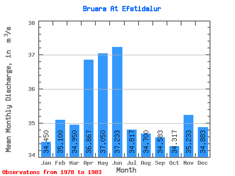
| Statistic | Jan | Feb | Mar | Apr | May | Jun | Jul | Aug | Sep | Oct | Nov | Dec | Annual |
|---|---|---|---|---|---|---|---|---|---|---|---|---|---|
| Mean | 34.45 | 35.10 | 34.95 | 36.87 | 37.05 | 37.23 | 34.82 | 34.70 | 34.58 | 34.32 | 35.23 | 34.88 | 35.35 |
| Standard Deviation | 0.74 | 1.27 | 1.81 | 2.48 | 2.81 | 2.24 | 1.05 | 1.87 | 1.64 | 1.22 | 1.81 | 1.84 | 0.71 |
| Min | 33.70 | 33.40 | 33.10 | 33.80 | 33.90 | 35.20 | 33.70 | 33.10 | 32.80 | 32.30 | 32.80 | 31.90 | 34.52 |
| Max | 35.50 | 36.90 | 38.10 | 41.00 | 39.90 | 40.50 | 36.30 | 37.80 | 37.00 | 35.70 | 37.30 | 37.10 | 36.32 |
| Coefficient of Variation | 0.02 | 0.04 | 0.05 | 0.07 | 0.08 | 0.06 | 0.03 | 0.05 | 0.05 | 0.04 | 0.05 | 0.05 | 0.02 |
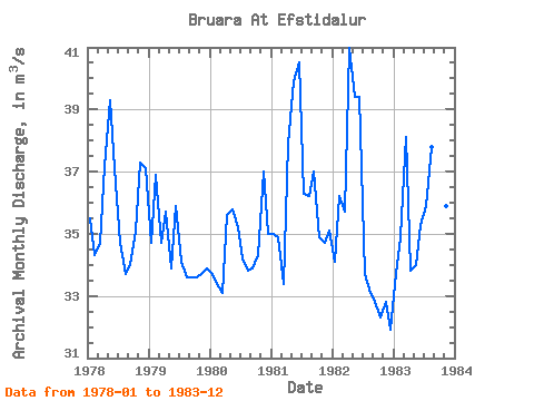
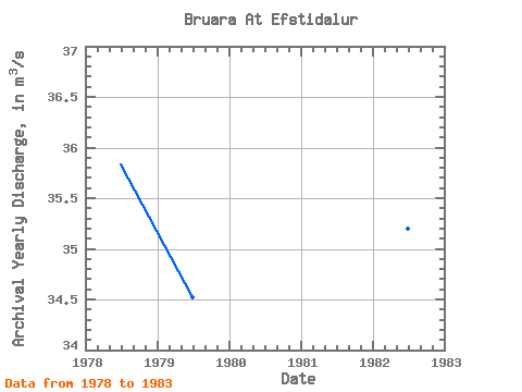
| Year | Jan | Feb | Mar | Apr | May | Jun | Jul | Aug | Sep | Oct | Nov | Dec | Annual | 1978 | 35.50 | 34.30 | 34.70 | 37.20 | 39.30 | 37.10 | 34.70 | 33.70 | 34.00 | 35.10 | 37.30 | 37.10 | 35.83 | 1979 | 34.70 | 36.90 | 34.70 | 35.70 | 33.90 | 35.90 | 34.10 | 33.60 | 33.60 | 33.60 | 33.70 | 33.90 | 34.52 | 1980 | 33.70 | 33.40 | 33.10 | 35.60 | 35.80 | 35.20 | 34.20 | 33.80 | 33.90 | 34.30 | 37.00 | 35.00 | 34.58 | 1981 | 35.00 | 34.90 | 33.40 | 37.90 | 39.90 | 40.50 | 36.30 | 36.20 | 37.00 | 34.90 | 34.70 | 35.10 | 36.32 | 1982 | 34.10 | 36.20 | 35.70 | 41.00 | 39.40 | 39.40 | 33.70 | 33.10 | 32.80 | 32.30 | 32.80 | 31.90 | 35.20 | 1983 | 33.70 | 34.90 | 38.10 | 33.80 | 34.00 | 35.30 | 35.90 | 37.80 | 36.20 | 35.70 | 35.90 | 36.30 | 35.63 |
|---|
 Return to R-Arctic Net Home Page