|
|
|||||||||||||||||
| Point ID: 7720 | Downloads | Plots | Site Data | Code: II004 |
|
|
|||||||||||||||||
| Download | |
|---|---|
| Site Descriptor Information | Site Time Series Data |
| Link to all available data | |
|
|
| View: | Statistics | Time Series |
| Units: | mm |
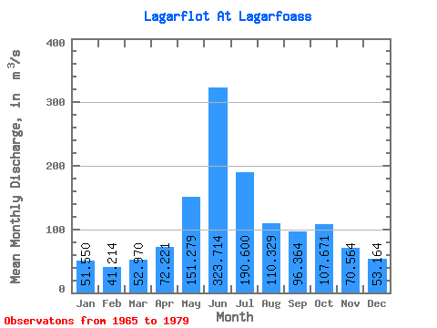
| Statistic | Jan | Feb | Mar | Apr | May | Jun | Jul | Aug | Sep | Oct | Nov | Dec | Annual |
|---|---|---|---|---|---|---|---|---|---|---|---|---|---|
| Mean | 51.55 | 41.21 | 52.97 | 72.22 | 151.28 | 323.71 | 190.60 | 110.33 | 96.36 | 107.67 | 70.56 | 53.16 | 110.14 |
| Standard Deviation | 45.01 | 32.93 | 45.12 | 64.63 | 86.61 | 69.16 | 47.82 | 26.50 | 36.22 | 60.79 | 73.62 | 46.81 | 15.94 |
| Min | 7.90 | 10.30 | 5.50 | 16.80 | 17.50 | 194.00 | 97.40 | 79.50 | 44.00 | 43.00 | 15.50 | 9.79 | 74.56 |
| Max | 148.00 | 133.00 | 145.00 | 285.00 | 266.00 | 436.00 | 277.00 | 179.00 | 153.00 | 240.00 | 310.00 | 179.00 | 135.56 |
| Coefficient of Variation | 0.87 | 0.80 | 0.85 | 0.90 | 0.57 | 0.21 | 0.25 | 0.24 | 0.38 | 0.56 | 1.04 | 0.88 | 0.14 |
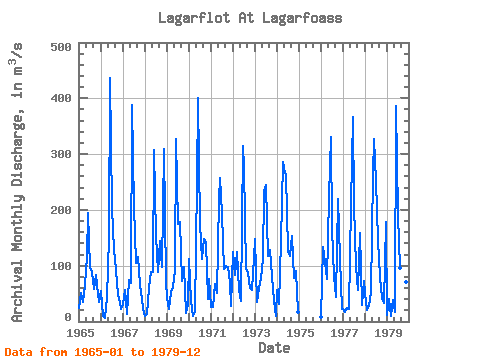
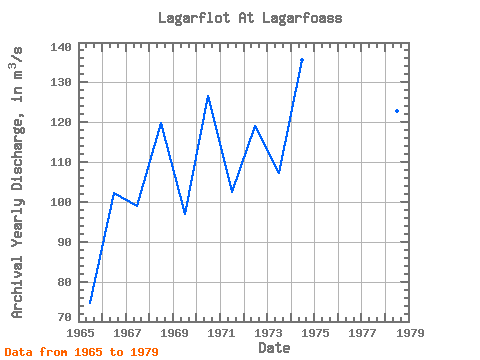
| Year | Jan | Feb | Mar | Apr | May | Jun | Jul | Aug | Sep | Oct | Nov | Dec | Annual | 1965 | 24.10 | 51.10 | 34.40 | 65.10 | 116.00 | 194.00 | 97.40 | 88.50 | 58.10 | 82.70 | 49.00 | 34.30 | 74.56 | 1966 | 54.40 | 10.30 | 5.50 | 43.00 | 150.00 | 436.00 | 203.00 | 128.00 | 91.70 | 47.10 | 35.20 | 21.70 | 102.16 | 1967 | 32.20 | 56.40 | 12.70 | 74.00 | 69.70 | 388.00 | 206.00 | 105.00 | 116.00 | 65.50 | 41.20 | 22.30 | 99.08 | 1968 | 10.50 | 13.70 | 60.70 | 89.00 | 89.00 | 308.00 | 154.00 | 89.50 | 145.00 | 97.90 | 310.00 | 71.70 | 119.92 | 1969 | 41.60 | 22.70 | 52.80 | 61.40 | 91.50 | 327.00 | 175.00 | 179.00 | 72.00 | 97.00 | 15.50 | 28.80 | 97.03 | 1970 | 112.00 | 36.40 | 9.68 | 16.80 | 251.00 | 401.00 | 175.00 | 112.00 | 148.00 | 140.00 | 41.00 | 76.00 | 126.57 | 1971 | 25.70 | 26.00 | 68.10 | 51.90 | 219.00 | 258.00 | 192.00 | 94.90 | 100.00 | 97.20 | 68.60 | 27.80 | 102.43 | 1972 | 125.00 | 84.00 | 125.00 | 56.50 | 36.20 | 314.00 | 277.00 | 93.20 | 86.30 | 59.80 | 56.20 | 114.00 | 118.93 | 1973 | 148.00 | 35.60 | 60.70 | 78.40 | 112.00 | 233.00 | 244.00 | 118.00 | 128.00 | 82.10 | 36.10 | 9.79 | 107.14 | 1974 | 55.80 | 30.80 | 145.00 | 285.00 | 266.00 | 262.00 | 127.00 | 118.00 | 153.00 | 77.10 | 90.60 | 16.40 | 135.56 | 1976 | 7.90 | 133.00 | 107.00 | 75.50 | 224.00 | 330.00 | 168.00 | 79.50 | 44.00 | 219.00 | 112.00 | 23.00 | 126.91 | 1977 | 22.00 | 16.50 | 24.00 | 22.50 | 211.00 | 367.00 | 208.00 | 98.50 | 57.00 | 159.00 | 29.00 | 72.50 | 107.25 | 1978 | 51.00 | 20.00 | 27.00 | 53.00 | 265.00 | 327.00 | 251.00 | 145.00 | 79.00 | 43.00 | 33.00 | 179.00 | 122.75 | 1979 | 11.50 | 40.50 | 9.00 | 39.00 | 17.50 | 387.00 | 191.00 | 95.50 | 71.00 | 240.00 | 70.50 | 47.00 | 101.62 |
|---|
 Return to R-Arctic Net Home Page