|
|
|||||||||||||||||
| Point ID: 7694 | Downloads | Plots | Site Data | Code: 15388100 |
|
|
|||||||||||||||||
| Download | |
|---|---|
| Site Descriptor Information | Site Time Series Data |
| Link to all available data | |
|
|
| View: | Statistics | Time Series |
| Units: | mm |
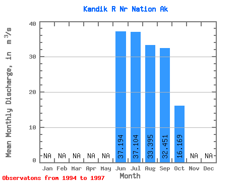
| Statistic | Jan | Feb | Mar | Apr | May | Jun | Jul | Aug | Sep | Oct | Nov | Dec | Annual |
|---|---|---|---|---|---|---|---|---|---|---|---|---|---|
| Mean | 37.19 | 37.10 | 33.40 | 32.45 | 16.17 | ||||||||
| Standard Deviation | 26.29 | 16.04 | 14.95 | 17.75 | |||||||||
| Min | 18.60 | 21.04 | 16.25 | 20.25 | 16.17 | ||||||||
| Max | 55.78 | 53.12 | 43.69 | 52.81 | 16.17 | ||||||||
| Coefficient of Variation | 0.71 | 0.43 | 0.45 | 0.55 |
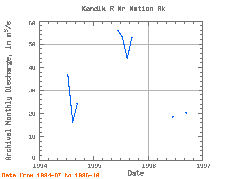
| Year | Jan | Feb | Mar | Apr | May | Jun | Jul | Aug | Sep | Oct | Nov | Dec | Annual | 1994 | 37.15 | 16.25 | 24.30 | 1995 | 55.78 | 53.12 | 43.69 | 52.81 | 1996 | 18.60 | 21.04 | 40.24 | 20.25 | 16.17 | 1997 |
|---|
 Return to R-Arctic Net Home Page