|
|
|||||||||||||||||
| Point ID: 7686 | Downloads | Plots | Site Data | Code: 15564600 |
|
|
|||||||||||||||||
| Download | |
|---|---|
| Site Descriptor Information | Site Time Series Data |
| Link to all available data | |
|
|
| View: | Statistics | Time Series |
| Units: | mm |
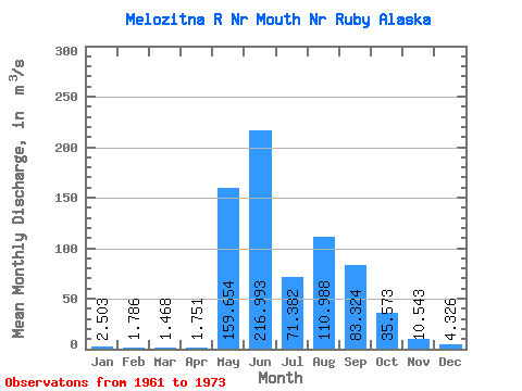
| Statistic | Jan | Feb | Mar | Apr | May | Jun | Jul | Aug | Sep | Oct | Nov | Dec | Annual |
|---|---|---|---|---|---|---|---|---|---|---|---|---|---|
| Mean | 2.50 | 1.79 | 1.47 | 1.75 | 159.65 | 216.99 | 71.38 | 110.99 | 83.32 | 35.57 | 10.54 | 4.33 | 57.43 |
| Standard Deviation | 2.01 | 1.46 | 1.09 | 1.01 | 104.21 | 94.82 | 35.36 | 91.59 | 59.77 | 28.13 | 5.84 | 2.53 | 21.08 |
| Min | 0.00 | 0.00 | 0.00 | 0.10 | 3.82 | 24.05 | 15.37 | 22.10 | 16.30 | 9.17 | 2.34 | 0.59 | 16.23 |
| Max | 6.79 | 4.81 | 3.40 | 3.68 | 344.41 | 317.81 | 140.65 | 300.55 | 207.01 | 116.37 | 23.21 | 9.62 | 85.74 |
| Coefficient of Variation | 0.80 | 0.82 | 0.74 | 0.58 | 0.65 | 0.44 | 0.49 | 0.82 | 0.72 | 0.79 | 0.55 | 0.58 | 0.37 |
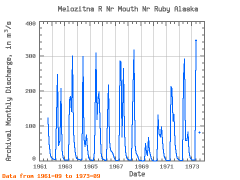
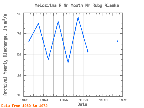
| Year | Jan | Feb | Mar | Apr | May | Jun | Jul | Aug | Sep | Oct | Nov | Dec | Annual | 1961 | 122.00 | 52.24 | 13.87 | 9.62 | 1962 | 6.79 | 4.81 | 3.40 | 3.68 | 121.83 | 246.69 | 44.03 | 57.90 | 207.01 | 32.20 | 11.18 | 4.10 | 61.97 | 1963 | 2.21 | 1.90 | 1.92 | 2.18 | 173.68 | 184.35 | 140.65 | 300.55 | 81.96 | 44.01 | 18.03 | 6.28 | 79.81 | 1964 | 4.81 | 3.96 | 3.11 | 2.83 | 3.82 | 299.13 | 63.17 | 41.35 | 73.55 | 33.48 | 10.19 | 3.65 | 45.25 | 1965 | 1.98 | 1.50 | 1.42 | 1.78 | 25.78 | 308.47 | 118.07 | 178.94 | 196.97 | 116.37 | 23.21 | 7.08 | 81.80 | 1966 | 4.53 | 2.26 | 1.42 | 1.70 | 124.44 | 216.64 | 56.66 | 30.99 | 26.86 | 23.83 | 10.33 | 3.82 | 41.95 | 1967 | 1.12 | 0.96 | 0.96 | 2.35 | 286.68 | 283.28 | 67.41 | 263.90 | 80.37 | 27.31 | 9.51 | 5.07 | 85.74 | 1968 | 3.23 | 2.40 | 2.26 | 2.26 | 202.54 | 317.81 | 47.69 | 22.10 | 16.30 | 10.61 | 2.49 | 0.67 | 52.53 | 1969 | 0.19 | 0.00 | 0.00 | 0.10 | 48.82 | 24.05 | 15.37 | 66.62 | 27.56 | 9.17 | 2.34 | 0.59 | 16.23 | 1970 | 0.00 | 0.00 | 0.00 | 0.54 | 131.54 | 76.41 | 68.40 | 97.44 | 56.94 | 25.05 | 8.83 | 3.42 | 39.05 | 1971 | 1.43 | 0.74 | 0.58 | 0.87 | 213.07 | 205.18 | 113.48 | 133.29 | 50.57 | 25.78 | 7.64 | 3.11 | 62.98 | 1972 | 1.54 | 1.00 | 0.82 | 0.95 | 239.25 | 292.06 | 57.56 | 57.93 | 82.04 | 26.83 | 8.91 | 4.50 | 64.45 | 1973 | 2.21 | 1.90 | 1.73 | 1.77 | 344.41 | 149.85 | 64.10 | 80.85 | 61.07 |
|---|
 Return to R-Arctic Net Home Page