|
|
|||||||||||||||||
| Point ID: 7677 | Downloads | Plots | Site Data | Code: 15348000 |
|
|
|||||||||||||||||
| Download | |
|---|---|
| Site Descriptor Information | Site Time Series Data |
| Link to all available data | |
|
|
| View: | Statistics | Time Series |
| Units: | mm |
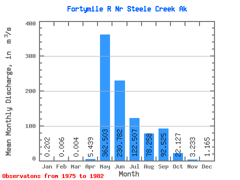
| Statistic | Jan | Feb | Mar | Apr | May | Jun | Jul | Aug | Sep | Oct | Nov | Dec | Annual |
|---|---|---|---|---|---|---|---|---|---|---|---|---|---|
| Mean | 0.20 | 0.01 | 0.00 | 5.44 | 362.50 | 230.78 | 122.51 | 78.26 | 92.53 | 22.13 | 3.23 | 1.17 | 71.79 |
| Standard Deviation | 0.23 | 0.02 | 0.01 | 10.17 | 124.56 | 127.91 | 45.94 | 51.64 | 83.73 | 13.36 | 3.59 | 1.29 | 23.67 |
| Min | 0.00 | 0.00 | 0.00 | 0.03 | 197.11 | 112.89 | 51.05 | 25.55 | 26.63 | 7.36 | 0.11 | 0.01 | 44.53 |
| Max | 0.53 | 0.04 | 0.03 | 28.02 | 543.36 | 478.55 | 170.56 | 170.22 | 269.87 | 47.23 | 8.80 | 2.74 | 111.47 |
| Coefficient of Variation | 1.14 | 2.65 | 2.65 | 1.87 | 0.34 | 0.55 | 0.38 | 0.66 | 0.91 | 0.60 | 1.11 | 1.10 | 0.33 |
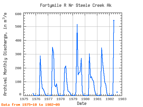
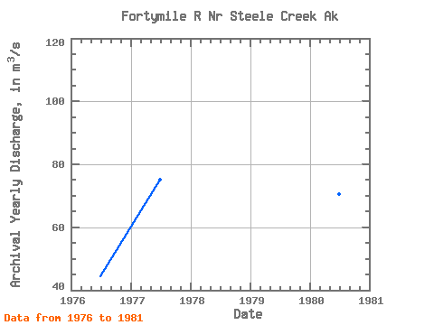
| Year | Jan | Feb | Mar | Apr | May | Jun | Jul | Aug | Sep | Oct | Nov | Dec | Annual | 1975 | 16.64 | 0.11 | 0.01 | 1976 | 0.00 | 0.00 | 0.00 | 1.09 | 286.96 | 112.89 | 51.05 | 47.49 | 26.63 | 7.36 | 0.64 | 0.21 | 44.53 | 1977 | 0.00 | 0.00 | 0.00 | 0.19 | 349.22 | 305.92 | 76.44 | 64.16 | 85.89 | 20.49 | 0.56 | 0.21 | 75.26 | 1978 | 0.03 | 0.00 | 0.00 | 2.34 | 197.11 | 212.96 | 106.66 | 33.03 | 29.74 | 21.14 | 6.42 | 2.72 | 51.01 | 1979 | 0.53 | 0.00 | 0.00 | 28.02 | 514.49 | 150.05 | 166.18 | 170.22 | 269.87 | 30.68 | 5.55 | 2.11 | 111.47 | 1980 | 0.46 | 0.00 | 0.00 | 0.38 | 301.39 | 128.91 | 136.26 | 115.49 | 105.28 | 47.23 | 8.80 | 2.74 | 70.58 | 1981 | 0.33 | 0.00 | 0.00 | 6.03 | 344.98 | 226.20 | 170.56 | 91.86 | 82.72 | 11.35 | 0.55 | 0.16 | 77.89 | 1982 | 0.07 | 0.04 | 0.03 | 0.03 | 543.36 | 478.55 | 150.39 | 25.55 | 47.54 |
|---|
 Return to R-Arctic Net Home Page