|
|
|||||||||||||||||
| Point ID: 7503 | Downloads | Plots | Site Data | Other Close Sites | Code: 70495 |
|
|
|||||||||||||||||
| Download | |
|---|---|
| Site Descriptor Information | Site Time Series Data |
| Link to all available data | |
|
|
| View: | Statistics | Time Series |
| Units: | mm |
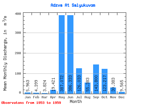
| Statistic | Jan | Feb | Mar | Apr | May | Jun | Jul | Aug | Sep | Oct | Nov | Dec | Annual |
|---|---|---|---|---|---|---|---|---|---|---|---|---|---|
| Mean | 5.96 | 4.40 | 3.82 | 19.42 | 387.07 | 386.33 | 126.03 | 55.38 | 143.80 | 123.22 | 30.38 | 9.56 | 108.16 |
| Standard Deviation | 1.52 | 0.91 | 0.74 | 26.61 | 191.00 | 260.05 | 41.68 | 38.89 | 74.98 | 59.40 | 15.64 | 3.16 | 16.91 |
| Min | 3.27 | 2.73 | 2.52 | 3.78 | 8.43 | 157.00 | 63.20 | 28.60 | 78.50 | 61.20 | 12.80 | 6.21 | 77.63 |
| Max | 7.64 | 5.38 | 4.91 | 76.40 | 535.00 | 851.00 | 176.00 | 133.00 | 259.00 | 201.00 | 51.90 | 15.40 | 122.19 |
| Coefficient of Variation | 0.26 | 0.21 | 0.19 | 1.37 | 0.49 | 0.67 | 0.33 | 0.70 | 0.52 | 0.48 | 0.52 | 0.33 | 0.16 |
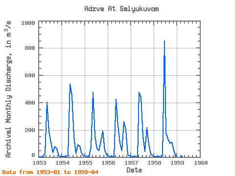
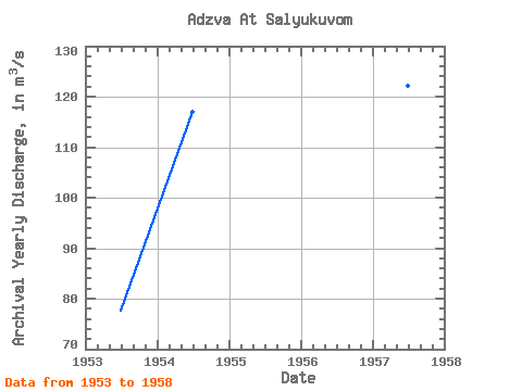
| Year | Jan | Feb | Mar | Apr | May | Jun | Jul | Aug | Sep | Oct | Nov | Dec | Annual | 1953 | 3.27 | 2.73 | 2.52 | 27.40 | 405.00 | 189.00 | 110.00 | 32.90 | 78.50 | 61.20 | 12.80 | 6.21 | 77.63 | 1954 | 5.22 | 3.66 | 3.35 | 15.10 | 535.00 | 451.00 | 154.00 | 28.60 | 90.30 | 80.50 | 25.60 | 10.40 | 116.89 | 1955 | 7.46 | 4.76 | 3.98 | 76.40 | 474.00 | 157.00 | 63.20 | 49.10 | 118.00 | 193.00 | 51.90 | 15.40 | 101.18 | 1956 | 7.64 | 5.38 | 3.89 | 3.96 | 424.00 | 232.00 | 102.00 | 48.40 | 259.00 | 201.00 | 21.20 | 8.73 | 109.77 | 1957 | 6.76 | 4.96 | 4.10 | 3.78 | 476.00 | 438.00 | 151.00 | 40.30 | 216.00 | 93.60 | 23.30 | 8.44 | 122.19 | 1958 | 6.07 | 4.82 | 4.91 | 4.90 | 8.43 | 851.00 | 176.00 | 133.00 | 101.00 | 110.00 | 47.50 | 8.21 | 121.32 | 1959 | 5.32 | 4.48 | 4.02 | 4.41 |
|---|
| Other Close Sites | ||||||
|---|---|---|---|---|---|---|
| PointID | Latitude | Longitude | Drainage Area | Source | Name | |
| 7498 | "Usa At Adzva-Vom" | 66.55 | -1317360 | SHI | 165.00 | |
 Return to R-Arctic Net Home Page