|
|
|||||||||||||||||
| Point ID: 7486 | Downloads | Plots | Site Data | Code: 70442 |
|
|
|||||||||||||||||
| Download | |
|---|---|
| Site Descriptor Information | Site Time Series Data |
| Link to all available data | |
|
|
| View: | Statistics | Time Series |
| Units: | mm |
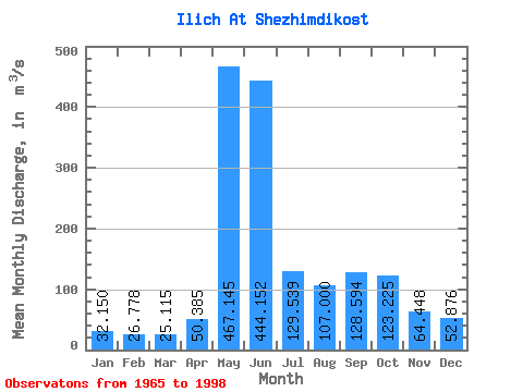
| Statistic | Jan | Feb | Mar | Apr | May | Jun | Jul | Aug | Sep | Oct | Nov | Dec | Annual |
|---|---|---|---|---|---|---|---|---|---|---|---|---|---|
| Mean | 32.15 | 26.78 | 25.11 | 50.38 | 467.14 | 444.15 | 129.54 | 107.00 | 128.59 | 123.22 | 64.45 | 52.88 | 135.56 |
| Standard Deviation | 4.47 | 4.74 | 4.17 | 47.41 | 175.66 | 222.14 | 58.65 | 53.14 | 62.03 | 48.33 | 22.10 | 61.71 | 18.81 |
| Min | 22.40 | 14.30 | 10.50 | 16.90 | 86.80 | 111.00 | 48.40 | 39.00 | 38.60 | 46.40 | 34.60 | 29.50 | 101.72 |
| Max | 41.00 | 34.60 | 32.20 | 225.00 | 756.00 | 833.00 | 250.00 | 227.00 | 290.00 | 297.00 | 154.00 | 393.00 | 178.18 |
| Coefficient of Variation | 0.14 | 0.18 | 0.17 | 0.94 | 0.38 | 0.50 | 0.45 | 0.50 | 0.48 | 0.39 | 0.34 | 1.17 | 0.14 |
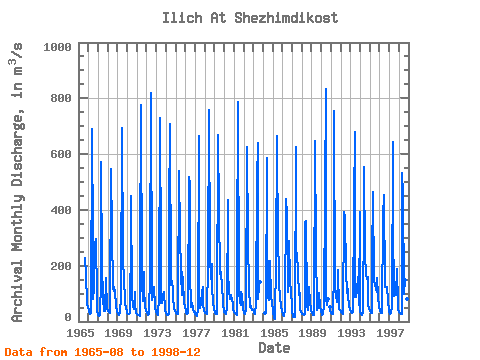
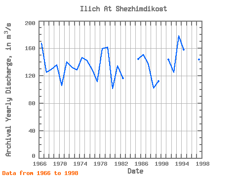
| Year | Jan | Feb | Mar | Apr | May | Jun | Jul | Aug | Sep | Oct | Nov | Dec | Annual | 1965 | 227.00 | 229.00 | 165.00 | 67.00 | 47.40 | 1966 | 41.00 | 33.40 | 26.40 | 30.90 | 689.00 | 290.00 | 81.70 | 115.00 | 275.00 | 297.00 | 84.70 | 40.80 | 167.07 | 1967 | 24.90 | 20.80 | 22.10 | 149.00 | 572.00 | 201.00 | 83.90 | 39.00 | 38.60 | 156.00 | 154.00 | 44.00 | 125.44 | 1968 | 38.90 | 34.60 | 28.80 | 40.90 | 547.00 | 318.00 | 116.00 | 109.00 | 125.00 | 106.00 | 55.60 | 35.40 | 129.60 | 1969 | 28.00 | 22.20 | 22.00 | 33.20 | 86.80 | 693.00 | 228.00 | 198.00 | 172.00 | 59.80 | 56.70 | 29.50 | 135.77 | 1970 | 29.20 | 26.60 | 26.40 | 31.30 | 311.00 | 449.00 | 96.60 | 53.60 | 46.00 | 106.00 | 58.40 | 31.90 | 105.50 | 1971 | 27.10 | 23.80 | 21.60 | 21.20 | 213.00 | 776.00 | 138.00 | 74.80 | 178.00 | 121.00 | 47.30 | 41.30 | 140.26 | 1972 | 30.10 | 23.70 | 23.60 | 28.00 | 171.00 | 818.00 | 110.00 | 76.60 | 96.40 | 122.00 | 50.90 | 35.30 | 132.13 | 1973 | 29.30 | 25.30 | 23.20 | 88.00 | 729.00 | 230.00 | 65.20 | 67.40 | 94.60 | 107.00 | 43.70 | 37.30 | 128.33 | 1974 | 29.00 | 24.50 | 21.70 | 25.50 | 386.00 | 707.00 | 130.00 | 144.00 | 113.00 | 86.50 | 48.70 | 39.00 | 146.24 | 1975 | 30.70 | 26.50 | 25.40 | 70.20 | 539.00 | 312.00 | 171.00 | 96.60 | 176.00 | 146.00 | 65.60 | 52.10 | 142.59 | 1976 | 39.30 | 30.80 | 27.40 | 32.20 | 519.00 | 492.00 | 174.00 | 50.70 | 65.40 | 46.40 | 34.60 | 34.90 | 128.89 | 1977 | 27.00 | 23.20 | 21.20 | 42.70 | 664.00 | 123.00 | 48.40 | 62.90 | 102.00 | 124.00 | 57.80 | 41.50 | 111.47 | 1978 | 32.00 | 28.70 | 25.10 | 31.50 | 208.00 | 757.00 | 233.00 | 153.00 | 206.00 | 124.00 | 68.00 | 49.40 | 159.64 | 1979 | 32.00 | 25.80 | 27.70 | 27.20 | 668.00 | 391.00 | 170.00 | 199.00 | 161.00 | 138.00 | 58.00 | 41.10 | 161.57 | 1980 | 32.30 | 28.70 | 26.50 | 53.10 | 436.00 | 173.00 | 113.00 | 81.30 | 93.60 | 77.80 | 64.60 | 40.70 | 101.72 | 1981 | 33.30 | 31.50 | 27.00 | 24.00 | 231.00 | 786.00 | 106.00 | 68.60 | 59.40 | 107.00 | 92.70 | 46.70 | 134.43 | 1982 | 31.60 | 28.00 | 26.10 | 42.10 | 624.00 | 289.00 | 115.00 | 52.20 | 62.00 | 49.60 | 41.50 | 40.20 | 116.78 | 1983 | 32.40 | 28.70 | 25.10 | 65.00 | 503.00 | 639.00 | 80.00 | 126.00 | 142.00 | 1984 | 32.20 | 35.40 | 586.00 | 349.00 | 88.40 | 78.70 | 216.00 | 84.80 | 79.70 | 75.00 | 1985 | 34.30 | 14.30 | 10.50 | 17.20 | 217.00 | 664.00 | 250.00 | 218.00 | 135.00 | 86.90 | 51.00 | 38.50 | 144.72 | 1986 | 22.40 | 19.70 | 24.40 | 36.00 | 438.00 | 381.00 | 183.00 | 107.00 | 290.00 | 153.00 | 94.20 | 64.80 | 151.12 | 1987 | 40.20 | 17.60 | 15.40 | 16.90 | 627.00 | 245.00 | 245.00 | 173.00 | 94.70 | 101.00 | 45.40 | 35.20 | 138.03 | 1988 | 28.50 | 25.50 | 24.30 | 26.10 | 353.00 | 359.00 | 59.30 | 40.30 | 73.30 | 124.00 | 69.70 | 40.30 | 101.94 | 1989 | 29.20 | 25.90 | 24.10 | 24.50 | 648.00 | 259.00 | 55.60 | 40.70 | 51.80 | 102.00 | 53.30 | 36.10 | 112.52 | 1990 | 28.60 | 24.60 | 26.20 | 60.00 | 460.00 | 833.00 | 86.00 | 57.80 | 80.90 | 53.50 | 36.10 | 1991 | 30.80 | 27.70 | 25.50 | 186.00 | 756.00 | 111.00 | 94.00 | 68.60 | 148.00 | 185.00 | 46.40 | 42.80 | 143.48 | 1992 | 34.20 | 31.30 | 29.00 | 27.10 | 392.00 | 376.00 | 180.00 | 101.00 | 141.00 | 92.00 | 58.40 | 42.60 | 125.38 | 1993 | 37.60 | 34.50 | 28.90 | 32.90 | 426.00 | 679.00 | 89.50 | 88.20 | 112.00 | 159.00 | 57.60 | 393.00 | 178.18 | 1994 | 32.30 | 27.40 | 24.60 | 32.10 | 397.00 | 554.00 | 237.00 | 171.00 | 151.00 | 161.00 | 62.50 | 43.70 | 157.80 | 1995 | 36.00 | 30.90 | 28.90 | 225.00 | 464.00 | 140.00 | 133.00 | 118.00 | 104.00 | 156.00 | 92.70 | 51.40 | 131.66 | 1996 | 36.90 | 31.20 | 30.40 | 29.50 | 379.00 | 453.00 | 123.00 | 123.00 | 123.00 | 125.00 | 74.30 | 42.80 | 130.93 | 1997 | 34.60 | 27.40 | 28.70 | 50.40 | 643.00 | 354.00 | 93.00 | 110.00 | 96.50 | 188.00 | 57.80 | 40.10 | 143.62 | 1998 | 35.10 | 32.10 | 28.40 | 27.60 | 533.00 | 456.00 | 98.20 | 148.00 | 120.00 | 86.40 | 80.50 | 34.00 | 139.94 |
|---|
 Return to R-Arctic Net Home Page