|
|
|||||||||||||||||
| Point ID: 7328 | Downloads | Plots | Site Data | Code: 49138 |
|
|
|||||||||||||||||
| Download | |
|---|---|
| Site Descriptor Information | Site Time Series Data |
| Link to all available data | |
|
|
| View: | Statistics | Time Series |
| Units: | mm |
| Statistic | Jan | Feb | Mar | Apr | May | Jun | Jul | Aug | Sep | Oct | Nov | Dec | Annual |
|---|---|---|---|---|---|---|---|---|---|---|---|---|---|
| Mean | 122.25 | 68.98 | 62.70 | 69.38 | 69.82 | ||||||||
| Standard Deviation | 32.57 | 21.73 | 22.95 | 26.06 | 16.88 | ||||||||
| Min | 75.00 | 38.70 | 33.20 | 33.60 | 47.10 | ||||||||
| Max | 149.00 | 117.00 | 107.00 | 118.00 | 94.30 | ||||||||
| Coefficient of Variation | 0.27 | 0.32 | 0.37 | 0.38 | 0.24 |
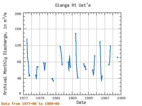
| Year | Jan | Feb | Mar | Apr | May | Jun | Jul | Aug | Sep | Oct | Nov | Dec | Annual | 1977 | 136.00 | 90.10 | 77.20 | 45.00 | 47.10 | 1978 | 46.60 | 38.20 | 68.30 | 67.90 | 1979 | 77.90 | 58.30 | 76.20 | 1980 | 38.70 | 40.00 | 33.60 | 1981 | 117.00 | 107.00 | 92.20 | 73.10 | 1982 | 79.40 | 57.80 | 94.90 | 66.70 | 1983 | 149.00 | 76.00 | 50.90 | 41.10 | 1984 | 75.00 | 66.70 | 69.70 | 61.60 | 1985 | 59.70 | 47.20 | 64.80 | 94.30 | 1986 | 129.00 | 57.00 | 33.20 | 44.70 | 1987 | 72.90 | 82.30 | 118.00 | 1988 | 45.80 | 90.60 | 92.20 |
|---|
 Return to R-Arctic Net Home Page
