|
|
|||||||||||||||||
| Point ID: 7279 | Downloads | Plots | Site Data | Other Close Sites | Code: 49034 |
|
|
|||||||||||||||||
| Download | |
|---|---|
| Site Descriptor Information | Site Time Series Data |
| Link to all available data | |
|

|
| View: | Statistics | Time Series |
| Units: | mm |
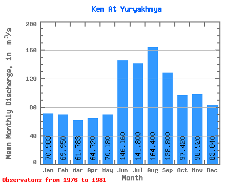
| Statistic | Jan | Feb | Mar | Apr | May | Jun | Jul | Aug | Sep | Oct | Nov | Dec | Annual |
|---|---|---|---|---|---|---|---|---|---|---|---|---|---|
| Mean | 70.98 | 69.95 | 61.78 | 64.72 | 70.18 | 146.16 | 141.80 | 164.40 | 128.80 | 97.42 | 98.92 | 83.84 | 99.78 |
| Standard Deviation | 13.83 | 15.45 | 14.17 | 50.07 | 31.81 | 52.17 | 38.44 | 23.89 | 15.60 | 20.38 | 39.70 | 20.93 | 16.87 |
| Min | 57.40 | 54.50 | 48.10 | 31.50 | 41.80 | 94.80 | 103.00 | 130.00 | 115.00 | 71.30 | 63.50 | 61.10 | 81.92 |
| Max | 90.50 | 91.70 | 85.30 | 153.00 | 119.00 | 212.00 | 196.00 | 192.00 | 154.00 | 124.00 | 161.00 | 110.00 | 125.67 |
| Coefficient of Variation | 0.20 | 0.22 | 0.23 | 0.77 | 0.45 | 0.36 | 0.27 | 0.14 | 0.12 | 0.21 | 0.40 | 0.25 | 0.17 |
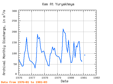
| Year | Jan | Feb | Mar | Apr | May | Jun | Jul | Aug | Sep | Oct | Nov | Dec | Annual | 1976 | 69.00 | 59.60 | 50.90 | 39.80 | 42.50 | 101.00 | 115.00 | 174.00 | 117.00 | 83.80 | 66.10 | 64.40 | 81.92 | 1977 | 60.10 | 54.50 | 48.10 | 31.50 | 68.00 | 188.00 | 166.00 | 174.00 | 127.00 | 104.00 | 109.00 | 110.00 | 103.35 | 1978 | 90.50 | 72.40 | 59.30 | 44.40 | 41.80 | 94.80 | 103.00 | 130.00 | 115.00 | 124.00 | 95.00 | 87.10 | 88.11 | 1979 | 85.50 | 84.30 | 71.70 | 54.90 | 119.00 | 212.00 | 196.00 | 192.00 | 131.00 | 104.00 | 161.00 | 96.60 | 125.67 | 1980 | 57.40 | 57.20 | 85.30 | 153.00 | 79.60 | 135.00 | 129.00 | 152.00 | 154.00 | 71.30 | 63.50 | 61.10 | 99.87 | 1981 | 63.40 | 91.70 | 55.40 |
|---|
| Other Close Sites | ||||||
|---|---|---|---|---|---|---|
| PointID | Latitude | Longitude | Drainage Area | Source | Name | |
| 7280 | "Kem At Yushkozero" | 64.78 | -2354759 | SHI | 172.00 | |
 Return to R-Arctic Net Home Page