|
|
|||||||||||||||||
| Point ID: 720 | Downloads | Plots | Site Data | Code: 07DB002 |
|
|
|||||||||||||||||
| Download | |
|---|---|
| Site Descriptor Information | Site Time Series Data |
| Link to all available data | |
|
|
| View: | Statistics | Time Series |
| Units: | mm |
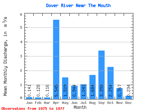
| Statistic | Jan | Feb | Mar | Apr | May | Jun | Jul | Aug | Sep | Oct | Nov | Dec | Annual |
|---|---|---|---|---|---|---|---|---|---|---|---|---|---|
| Mean | 0.14 | 0.13 | 0.12 | 5.54 | 1.51 | 0.94 | 1.04 | 1.68 | 3.39 | 2.25 | 0.77 | 0.23 | 0.52 |
| Standard Deviation | 0.10 | 0.12 | 0.12 | 5.95 | 0.96 | 0.09 | 0.11 | 1.93 | 4.02 | 1.93 | 0.66 | 0.10 | |
| Min | 0.07 | 0.04 | 0.03 | 1.34 | 0.83 | 0.88 | 0.96 | 0.20 | 0.33 | 0.89 | 0.30 | 0.15 | 0.52 |
| Max | 0.21 | 0.21 | 0.20 | 9.75 | 2.19 | 1.01 | 1.12 | 3.86 | 7.94 | 3.62 | 1.23 | 0.34 | 0.52 |
| Coefficient of Variation | 0.68 | 0.96 | 1.07 | 1.07 | 0.64 | 0.10 | 0.11 | 1.14 | 1.18 | 0.86 | 0.85 | 0.42 |
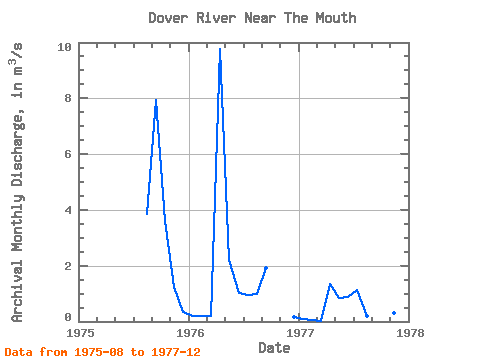
| Year | Jan | Feb | Mar | Apr | May | Jun | Jul | Aug | Sep | Oct | Nov | Dec | Annual | 1975 | 3.86 | 7.94 | 3.62 | 1.23 | 0.34 | 1976 | 0.21 | 0.21 | 0.20 | 9.75 | 2.19 | 1.01 | 0.96 | 0.99 | 1.91 | 0.15 | 1977 | 0.07 | 0.04 | 0.03 | 1.34 | 0.83 | 0.88 | 1.12 | 0.20 | 0.33 | 0.89 | 0.30 | 0.20 | 0.52 |
|---|
 Return to R-Arctic Net Home Page