|
|
|||||||||||||||||
| Point ID: 7140 | Downloads | Plots | Site Data | Other Close Sites | Code: 11667 |
|
|
|||||||||||||||||
| Download | |
|---|---|
| Site Descriptor Information | Site Time Series Data |
| Link to all available data | |
|
|
| View: | Statistics | Time Series |
| Units: | mm |
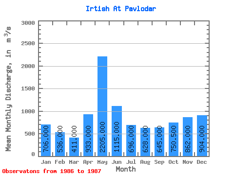
| Statistic | Jan | Feb | Mar | Apr | May | Jun | Jul | Aug | Sep | Oct | Nov | Dec | Annual |
|---|---|---|---|---|---|---|---|---|---|---|---|---|---|
| Mean | 706.00 | 536.00 | 411.00 | 933.00 | 2205.00 | 1115.00 | 696.00 | 628.00 | 645.00 | 750.50 | 862.00 | 904.00 | 906.33 |
| Standard Deviation | 25.46 | 207.89 | 219.20 | 77.78 | 137.18 | 63.64 | 169.71 | 251.02 | |||||
| Min | 706.00 | 536.00 | 393.00 | 786.00 | 2050.00 | 1060.00 | 599.00 | 583.00 | 525.00 | 573.00 | 862.00 | 904.00 | 906.33 |
| Max | 706.00 | 536.00 | 429.00 | 1080.00 | 2360.00 | 1170.00 | 793.00 | 673.00 | 765.00 | 928.00 | 862.00 | 904.00 | 906.33 |
| Coefficient of Variation | 0.06 | 0.22 | 0.10 | 0.07 | 0.20 | 0.10 | 0.26 | 0.33 |
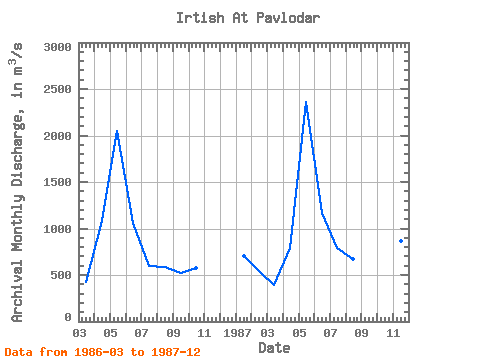
| Year | Jan | Feb | Mar | Apr | May | Jun | Jul | Aug | Sep | Oct | Nov | Dec | Annual | 1986 | 429.00 | 1080.00 | 2050.00 | 1060.00 | 599.00 | 583.00 | 525.00 | 573.00 | 1987 | 706.00 | 536.00 | 393.00 | 786.00 | 2360.00 | 1170.00 | 793.00 | 673.00 | 765.00 | 928.00 | 862.00 | 904.00 | 906.33 |
|---|
| Other Close Sites | ||||||
|---|---|---|---|---|---|---|
| PointID | Latitude | Longitude | Drainage Area | Source | Name | |
| 6948 | "Irtish At Pavlodar" | 52.25 | -932209 | SHI | 2396.00 | |
 Return to R-Arctic Net Home Page