|
|
|||||||||||||||||
| Point ID: 711 | Downloads | Plots | Site Data | Code: 07DA012 |
|
|
|||||||||||||||||
| Download | |
|---|---|
| Site Descriptor Information | Site Time Series Data |
| Link to all available data | |
|
|
| View: | Statistics | Time Series |
| Units: | mm |
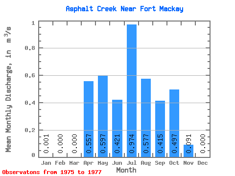
| Statistic | Jan | Feb | Mar | Apr | May | Jun | Jul | Aug | Sep | Oct | Nov | Dec | Annual |
|---|---|---|---|---|---|---|---|---|---|---|---|---|---|
| Mean | 0.00 | 0.00 | 0.00 | 0.56 | 0.60 | 0.42 | 0.97 | 0.58 | 0.41 | 0.50 | 0.09 | 0.00 | 0.30 |
| Standard Deviation | 0.00 | 0.00 | 0.00 | 0.44 | 0.42 | 0.08 | 0.01 | 0.54 | 0.38 | 0.03 | 0.01 | 0.00 | 0.00 |
| Min | 0.00 | 0.00 | 0.00 | 0.25 | 0.30 | 0.36 | 0.96 | 0.20 | 0.17 | 0.48 | 0.09 | 0.00 | 0.30 |
| Max | 0.00 | 0.00 | 0.00 | 0.87 | 0.89 | 0.48 | 0.98 | 1.19 | 0.86 | 0.52 | 0.10 | 0.00 | 0.30 |
| Coefficient of Variation | 1.41 | 0.79 | 0.70 | 0.20 | 0.01 | 0.93 | 0.93 | 0.06 | 0.10 | 0.00 |
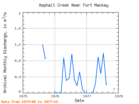
| Year | Jan | Feb | Mar | Apr | May | Jun | Jul | Aug | Sep | Oct | Nov | Dec | Annual | 1975 | 1.19 | 0.86 | 1976 | 0.00 | 0.00 | 0.00 | 0.87 | 0.30 | 0.36 | 0.96 | 0.34 | 0.17 | 0.52 | 0.09 | 0.00 | 0.30 | 1977 | 0.00 | 0.00 | 0.00 | 0.25 | 0.89 | 0.48 | 0.98 | 0.20 | 0.21 | 0.48 | 0.10 | 0.00 | 0.30 |
|---|
 Return to R-Arctic Net Home Page