|
|
|||||||||||||||||
| Point ID: 7102 | Downloads | Plots | Site Data | Code: 11541 |
|
|
|||||||||||||||||
| Download | |
|---|---|
| Site Descriptor Information | Site Time Series Data |
| Link to all available data | |
|
|
| View: | Statistics | Time Series |
| Units: | mm |
| Statistic | Jan | Feb | Mar | Apr | May | Jun | Jul | Aug | Sep | Oct | Nov | Dec | Annual |
|---|---|---|---|---|---|---|---|---|---|---|---|---|---|
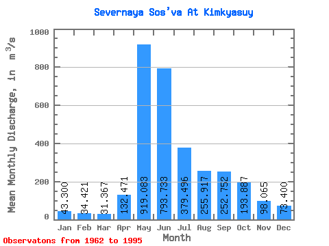
| Mean | 43.30 | 34.42 | 31.37 | 132.47 | 919.08 | 793.73 | 379.50 | 255.92 | 252.75 | 193.89 | 98.06 | 73.40 | 265.93 |
| Standard Deviation | 12.87 | 10.77 | 9.30 | 255.19 | 307.42 | 416.71 | 252.19 | 201.61 | 148.15 | 113.43 | 37.14 | 65.39 | 67.21 |
| Min | 21.80 | 19.10 | 18.00 | 17.30 | 266.00 | 0.60 | 50.40 | 87.70 | 69.60 | 57.30 | 42.20 | 39.10 | 146.28 |
| Max | 77.50 | 66.00 | 51.10 | 1250.00 | 1430.00 | 1540.00 | 1030.00 | 946.00 | 534.00 | 554.00 | 164.00 | 366.00 | 393.12 |
| Coefficient of Variation | 0.30 | 0.31 | 0.30 | 1.93 | 0.33 | 0.53 | 0.67 | 0.79 | 0.59 | 0.58 | 0.38 | 0.89 | 0.25 |
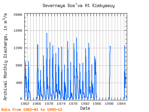
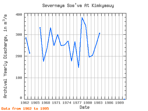
| Year | Jan | Feb | Mar | Apr | May | Jun | Jul | Aug | Sep | Oct | Nov | Dec | Annual | 1962 | 33.70 | 31.10 | 35.10 | 241.00 | 869.00 | 577.00 | 416.00 | 283.00 | 534.00 | 229.00 | 142.00 | 65.80 | 288.06 | 1963 | 42.70 | 30.50 | 28.20 | 57.30 | 892.00 | 623.00 | 185.00 | 207.00 | 204.00 | 163.00 | 75.50 | 58.30 | 213.88 | 1966 | 54.80 | 39.00 | 34.70 | 37.40 | 1280.00 | 1250.00 | 179.00 | 113.00 | 432.00 | 364.00 | 149.00 | 53.90 | 332.23 | 1967 | 21.80 | 19.10 | 20.50 | 224.00 | 684.00 | 382.00 | 223.00 | 128.00 | 86.60 | 115.00 | 125.00 | 70.20 | 174.93 | 1968 | 54.00 | 40.00 | 36.40 | 116.00 | 1020.00 | 537.00 | 323.00 | 267.00 | 138.00 | 137.00 | 85.20 | 48.70 | 233.53 | 1969 | 36.40 | 26.60 | 25.00 | 34.10 | 354.00 | 1540.00 | 866.00 | 259.00 | 530.00 | 178.00 | 76.50 | 53.20 | 331.57 | 1970 | 32.30 | 28.80 | 29.50 | 68.40 | 554.00 | 1320.00 | 394.00 | 172.00 | 121.00 | 91.80 | 129.00 | 52.50 | 249.44 | 1971 | 33.10 | 26.60 | 23.20 | 27.10 | 686.00 | 1250.00 | 848.00 | 159.00 | 196.00 | 166.00 | 123.00 | 64.80 | 300.23 | 1972 | 46.10 | 39.60 | 37.30 | 69.60 | 553.00 | 1080.00 | 199.00 | 219.00 | 181.00 | 362.00 | 120.00 | 72.40 | 248.25 | 1973 | 56.40 | 46.00 | 42.60 | 429.00 | 1200.00 | 320.00 | 154.00 | 220.00 | 134.00 | 213.00 | 143.00 | 69.40 | 252.28 | 1974 | 52.20 | 42.00 | 38.90 | 47.10 | 1220.00 | 1140.00 | 263.00 | 168.00 | 126.00 | 62.00 | 42.20 | 46.70 | 270.68 | 1975 | 36.80 | 24.00 | 20.70 | 17.30 | 810.00 | 0.60 | 361.00 | 278.00 | 256.00 | 198.00 | 76.40 | 48.90 | 177.31 | 1976 | 36.90 | 30.70 | 30.90 | 52.10 | 1350.00 | 962.00 | 449.00 | 87.70 | 69.60 | 57.30 | 50.50 | 39.10 | 267.98 | 1977 | 27.10 | 23.70 | 18.80 | 37.70 | 872.00 | 243.00 | 50.40 | 99.40 | 165.00 | 113.00 | 60.70 | 44.50 | 146.28 | 1978 | 35.40 | 24.80 | 23.40 | 27.90 | 266.00 | 1300.00 | 1030.00 | 506.00 | 514.00 | 554.00 | 164.00 | 96.80 | 378.52 | 1979 | 54.30 | 37.90 | 31.00 | 34.40 | 1430.00 | 780.00 | 504.00 | 559.00 | 304.00 | 207.00 | 102.00 | 58.50 | 341.84 | 1980 | 37.40 | 32.00 | 31.40 | 88.20 | 832.00 | 446.00 | 190.00 | 146.00 | 247.00 | 175.00 | 63.90 | 53.00 | 195.16 | 1981 | 40.70 | 33.20 | 31.00 | 37.50 | 846.00 | 676.00 | 177.00 | 141.00 | 163.00 | 143.00 | 65.90 | 72.80 | 202.26 | 1982 | 67.50 | 66.00 | 50.70 | 81.10 | 1180.00 | 817.00 | 461.00 | 104.00 | 78.10 | 72.30 | 44.60 | 39.10 | 255.12 | 1983 | 34.80 | 27.80 | 22.70 | 51.20 | 1310.00 | 1090.00 | 237.00 | 144.00 | 218.00 | 303.00 | 148.00 | 88.40 | 306.24 | 1984 | 77.50 | 55.70 | 51.10 | 54.40 | 812.00 | 461.00 | 194.00 | 155.00 | 375.00 | 184.00 | 97.70 | 56.30 | 214.47 | 1985 | 42.30 | 31.30 | 18.00 | 47.50 | 999.00 | 743.00 | 593.00 | 946.00 | 347.00 | 179.00 | 100.00 | 68.90 | 342.92 | 1990 | 36.40 | 26.90 | 29.10 | 49.00 | 969.00 | 1230.00 | 1995 | 48.60 | 42.80 | 42.60 | 1250.00 | 1070.00 | 282.00 | 432.00 | 525.00 | 394.00 | 193.00 | 71.40 | 366.00 | 393.12 |
|---|
 Return to R-Arctic Net Home Page