|
|
|||||||||||||||||
| Point ID: 7101 | Downloads | Plots | Site Data | Code: 11539 |
|
|
|||||||||||||||||
| Download | |
|---|---|
| Site Descriptor Information | Site Time Series Data |
| Link to all available data | |

|
|
| View: | Statistics | Time Series |
| Units: | mm |
| Statistic | Jan | Feb | Mar | Apr | May | Jun | Jul | Aug | Sep | Oct | Nov | Dec | Annual |
|---|---|---|---|---|---|---|---|---|---|---|---|---|---|
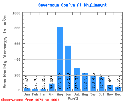
| Mean | 33.03 | 27.70 | 25.93 | 96.09 | 806.76 | 575.24 | 292.72 | 232.36 | 193.41 | 177.29 | 81.50 | 50.54 | 208.41 |
| Standard Deviation | 8.45 | 6.45 | 5.69 | 115.26 | 259.85 | 282.12 | 258.59 | 224.54 | 108.78 | 97.29 | 35.52 | 15.53 | 56.93 |
| Min | 17.70 | 11.60 | 13.10 | 27.40 | 359.00 | 165.00 | 58.50 | 52.10 | 48.70 | 32.00 | 31.00 | 27.80 | 116.42 |
| Max | 51.90 | 42.70 | 38.50 | 417.00 | 1410.00 | 1100.00 | 1110.00 | 784.00 | 451.00 | 404.00 | 157.00 | 82.50 | 321.52 |
| Coefficient of Variation | 0.26 | 0.23 | 0.22 | 1.20 | 0.32 | 0.49 | 0.88 | 0.97 | 0.56 | 0.55 | 0.44 | 0.31 | 0.27 |
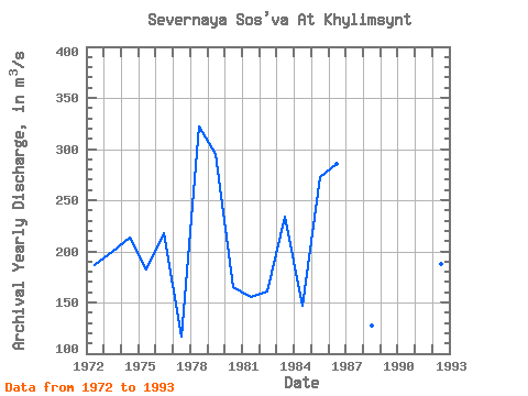
| Year | Jan | Feb | Mar | Apr | May | Jun | Jul | Aug | Sep | Oct | Nov | Dec | Annual | 1971 | 183.00 | 157.00 | 73.60 | 52.70 | 1972 | 34.30 | 28.60 | 24.90 | 77.30 | 442.00 | 750.00 | 109.00 | 159.00 | 116.00 | 306.00 | 120.00 | 70.60 | 186.47 | 1973 | 47.30 | 35.50 | 32.20 | 417.00 | 942.00 | 178.00 | 116.00 | 162.00 | 113.00 | 181.00 | 122.00 | 50.90 | 199.74 | 1974 | 35.60 | 28.30 | 27.30 | 33.20 | 1060.00 | 858.00 | 185.00 | 113.00 | 88.90 | 55.00 | 43.80 | 35.00 | 213.59 | 1975 | 29.80 | 25.90 | 20.00 | 225.00 | 583.00 | 414.00 | 196.00 | 179.00 | 201.00 | 168.00 | 78.10 | 62.90 | 181.89 | 1976 | 33.00 | 29.20 | 27.60 | 52.40 | 1090.00 | 805.00 | 368.00 | 71.70 | 48.70 | 32.00 | 31.00 | 27.80 | 218.03 | 1977 | 17.70 | 11.60 | 13.10 | 56.40 | 654.00 | 192.00 | 58.50 | 93.60 | 125.00 | 90.90 | 48.20 | 36.00 | 116.42 | 1978 | 25.70 | 23.50 | 19.70 | 37.10 | 359.00 | 1100.00 | 728.00 | 481.00 | 451.00 | 404.00 | 156.00 | 73.20 | 321.52 | 1979 | 43.10 | 25.60 | 21.60 | 29.80 | 1410.00 | 568.00 | 356.00 | 549.00 | 244.00 | 145.00 | 87.80 | 57.70 | 294.80 | 1980 | 37.80 | 28.70 | 27.00 | 112.00 | 674.00 | 341.00 | 133.00 | 146.00 | 254.00 | 128.00 | 58.20 | 39.40 | 164.93 | 1981 | 28.10 | 27.40 | 26.90 | 27.40 | 729.00 | 526.00 | 114.00 | 82.90 | 89.20 | 115.00 | 59.60 | 40.60 | 155.51 | 1982 | 27.60 | 27.80 | 27.40 | 71.20 | 757.00 | 535.00 | 237.00 | 68.00 | 56.10 | 49.50 | 40.50 | 35.70 | 161.07 | 1983 | 32.00 | 30.10 | 25.50 | 65.80 | 1090.00 | 806.00 | 133.00 | 104.00 | 132.00 | 215.00 | 102.00 | 75.20 | 234.22 | 1984 | 51.90 | 42.70 | 38.50 | 36.90 | 569.00 | 325.00 | 135.00 | 91.70 | 256.00 | 119.00 | 56.90 | 34.70 | 146.44 | 1985 | 18.60 | 16.70 | 16.90 | 27.50 | 855.00 | 474.00 | 609.00 | 752.00 | 240.00 | 170.00 | 47.00 | 44.60 | 272.61 | 1986 | 34.10 | 30.30 | 26.60 | 71.50 | 785.00 | 543.00 | 503.00 | 407.00 | 395.00 | 386.00 | 157.00 | 82.50 | 285.08 | 1988 | 32.70 | 28.00 | 24.00 | 40.00 | 441.00 | 354.00 | 85.70 | 106.00 | 175.00 | 137.00 | 66.30 | 44.40 | 127.84 | 1990 | 26.20 | 20.70 | 25.30 | 51.80 | 984.00 | 1100.00 | 312.00 | 80.50 | 135.00 | 258.00 | 100.00 | 50.90 | 262.03 | 1991 | 34.40 | 28.20 | 30.40 | 416.00 | 870.00 | 165.00 | 303.00 | 231.00 | 223.00 | 187.00 | 94.00 | 55.40 | 219.78 | 1992 | 35.00 | 28.90 | 32.60 | 33.10 | 767.00 | 422.00 | 226.00 | 166.00 | 255.00 | 142.00 | 83.50 | 56.90 | 187.33 | 1993 | 42.00 | 36.30 | 31.50 | 35.40 | 1090.00 | 748.00 | 130.00 | 52.10 | 106.00 | 236.00 | 85.90 | 34.20 | 218.95 | 1994 | 26.80 | 27.80 | 25.50 | 101.00 | 791.00 | 876.00 | 1110.00 | 784.00 | 368.00 | 219.00 |
|---|
 Return to R-Arctic Net Home Page