|
|
|||||||||||||||||
| Point ID: 6949 | Downloads | Plots | Site Data | Code: 11043 |
|
|
|||||||||||||||||
| Download | |
|---|---|
| Site Descriptor Information | Site Time Series Data |
| Link to all available data | |
|
|
| View: | Statistics | Time Series |
| Units: | mm |
| Statistic | Jan | Feb | Mar | Apr | May | Jun | Jul | Aug | Sep | Oct | Nov | Dec | Annual |
|---|---|---|---|---|---|---|---|---|---|---|---|---|---|
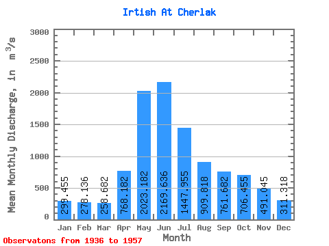
| Mean | 299.45 | 278.14 | 258.68 | 768.18 | 2023.18 | 2169.64 | 1447.95 | 909.82 | 761.68 | 706.46 | 491.05 | 311.32 | 868.79 |
| Standard Deviation | 98.58 | 100.33 | 78.21 | 321.43 | 367.03 | 589.86 | 600.05 | 346.84 | 323.74 | 331.94 | 218.75 | 100.02 | 204.77 |
| Min | 191.00 | 159.00 | 152.00 | 294.00 | 1460.00 | 852.00 | 410.00 | 321.00 | 268.00 | 292.00 | 251.00 | 196.00 | 453.08 |
| Max | 579.00 | 613.00 | 507.00 | 1740.00 | 2960.00 | 3230.00 | 2900.00 | 1730.00 | 1770.00 | 1940.00 | 1220.00 | 580.00 | 1344.50 |
| Coefficient of Variation | 0.33 | 0.36 | 0.30 | 0.42 | 0.18 | 0.27 | 0.41 | 0.38 | 0.42 | 0.47 | 0.45 | 0.32 | 0.24 |
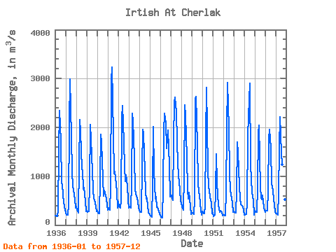
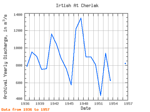
| Year | Jan | Feb | Mar | Apr | May | Jun | Jul | Aug | Sep | Oct | Nov | Dec | Annual | 1936 | 191.00 | 192.00 | 186.00 | 294.00 | 1520.00 | 2340.00 | 1730.00 | 850.00 | 840.00 | 610.00 | 362.00 | 309.00 | 785.33 | 1937 | 256.00 | 201.00 | 212.00 | 424.00 | 2080.00 | 2990.00 | 1820.00 | 1080.00 | 790.00 | 730.00 | 527.00 | 350.00 | 955.00 | 1938 | 385.00 | 314.00 | 248.00 | 1220.00 | 2160.00 | 1900.00 | 1160.00 | 1110.00 | 743.00 | 770.00 | 495.00 | 286.00 | 899.25 | 1939 | 290.00 | 272.00 | 282.00 | 823.00 | 2060.00 | 1750.00 | 1090.00 | 725.00 | 542.00 | 527.00 | 381.00 | 280.00 | 751.83 | 1940 | 293.00 | 248.00 | 236.00 | 936.00 | 1850.00 | 1700.00 | 946.00 | 589.00 | 710.00 | 673.00 | 533.00 | 394.00 | 759.00 | 1941 | 313.00 | 346.00 | 315.00 | 770.00 | 2960.00 | 3230.00 | 1860.00 | 1050.00 | 1100.00 | 963.00 | 681.00 | 350.00 | 1161.50 | 1942 | 483.00 | 385.00 | 357.00 | 488.00 | 2200.00 | 2440.00 | 1700.00 | 1200.00 | 896.00 | 1030.00 | 815.00 | 492.00 | 1040.50 | 1943 | 348.00 | 384.00 | 353.00 | 843.00 | 2280.00 | 2130.00 | 1380.00 | 734.00 | 627.00 | 598.00 | 500.00 | 332.00 | 875.75 | 1944 | 314.00 | 264.00 | 260.00 | 1190.00 | 1960.00 | 1870.00 | 1110.00 | 648.00 | 542.00 | 546.00 | 251.00 | 232.00 | 765.58 | 1945 | 213.00 | 194.00 | 171.00 | 801.00 | 2020.00 | 1100.00 | 534.00 | 586.00 | 372.00 | 359.00 | 281.00 | 240.00 | 572.58 | 1946 | 200.00 | 159.00 | 152.00 | 761.00 | 1910.00 | 2290.00 | 2090.00 | 1570.00 | 1770.00 | 1940.00 | 1220.00 | 580.00 | 1220.17 | 1947 | 579.00 | 613.00 | 507.00 | 1740.00 | 2520.00 | 2620.00 | 2320.00 | 1730.00 | 1260.00 | 1030.00 | 730.00 | 485.00 | 1344.50 | 1948 | 452.00 | 381.00 | 310.00 | 996.00 | 2460.00 | 2240.00 | 1380.00 | 725.00 | 542.00 | 666.00 | 380.00 | 223.00 | 896.25 | 1949 | 253.00 | 254.00 | 216.00 | 525.00 | 2570.00 | 2630.00 | 1660.00 | 874.00 | 672.00 | 604.00 | 295.00 | 211.00 | 897.00 | 1950 | 281.00 | 252.00 | 235.00 | 381.00 | 1800.00 | 2820.00 | 1160.00 | 757.00 | 731.00 | 568.00 | 454.00 | 240.00 | 806.58 | 1951 | 250.00 | 176.00 | 209.00 | 743.00 | 1460.00 | 852.00 | 410.00 | 321.00 | 268.00 | 292.00 | 260.00 | 196.00 | 453.08 | 1952 | 201.00 | 202.00 | 198.00 | 697.00 | 1960.00 | 2920.00 | 1980.00 | 1050.00 | 723.00 | 618.00 | 458.00 | 267.00 | 939.50 | 1953 | 275.00 | 272.00 | 249.00 | 685.00 | 1700.00 | 1480.00 | 795.00 | 547.00 | 429.00 | 414.00 | 379.00 | 288.00 | 626.08 | 1954 | 211.00 | 212.00 | 224.00 | 472.00 | 1800.00 | 2230.00 | 2900.00 | 1240.00 | 930.00 | 670.00 | 495.00 | 209.00 | 966.08 | 1955 | 294.00 | 271.00 | 268.00 | 772.00 | 1880.00 | 2040.00 | 760.00 | 567.00 | 528.00 | 608.00 | 366.00 | 287.00 | 720.08 | 1956 | 266.00 | 295.00 | 300.00 | 706.00 | 1760.00 | 1950.00 | 1580.00 | 823.00 | 812.00 | 678.00 | 415.00 | 270.00 | 821.25 | 1957 | 240.00 | 232.00 | 203.00 | 633.00 | 1600.00 | 2210.00 | 1490.00 | 1240.00 | 930.00 | 648.00 | 525.00 | 328.00 | 856.58 |
|---|
 Return to R-Arctic Net Home Page