|
|
|||||||||||||||||
| Point ID: 6948 | Downloads | Plots | Site Data | Other Close Sites | Code: 11037 |
|
|
|||||||||||||||||
| Download | |
|---|---|
| Site Descriptor Information | Site Time Series Data |
| Link to all available data | |
|
|
| View: | Statistics | Time Series |
| Units: | mm |
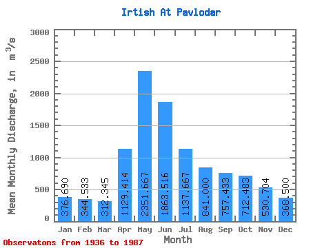
| Statistic | Jan | Feb | Mar | Apr | May | Jun | Jul | Aug | Sep | Oct | Nov | Dec | Annual |
|---|---|---|---|---|---|---|---|---|---|---|---|---|---|
| Mean | 376.69 | 344.53 | 312.35 | 1129.41 | 2351.67 | 1863.52 | 1137.67 | 841.00 | 757.43 | 712.48 | 530.70 | 368.50 | 886.85 |
| Standard Deviation | 128.16 | 122.75 | 86.63 | 377.13 | 578.91 | 789.66 | 517.19 | 318.52 | 308.62 | 236.83 | 204.94 | 154.09 | 185.07 |
| Min | 180.00 | 177.00 | 165.00 | 472.00 | 1220.00 | 574.00 | 452.00 | 420.00 | 374.00 | 410.00 | 216.00 | 219.00 | 505.08 |
| Max | 706.00 | 697.00 | 510.00 | 2080.00 | 3730.00 | 3420.00 | 2680.00 | 1670.00 | 1940.00 | 1650.00 | 1070.00 | 904.00 | 1300.58 |
| Coefficient of Variation | 0.34 | 0.36 | 0.28 | 0.33 | 0.25 | 0.42 | 0.46 | 0.38 | 0.41 | 0.33 | 0.39 | 0.42 | 0.21 |
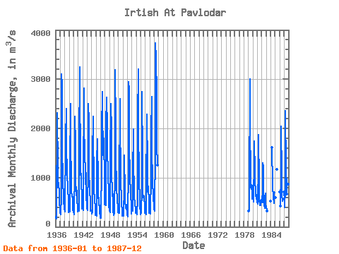
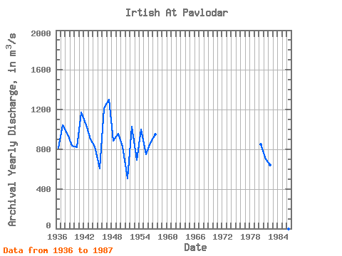
| Year | Jan | Feb | Mar | Apr | May | Jun | Jul | Aug | Sep | Oct | Nov | Dec | Annual | 1936 | 206.00 | 177.00 | 165.00 | 472.00 | 2020.00 | 2320.00 | 1140.00 | 802.00 | 902.00 | 664.00 | 568.00 | 286.00 | 810.17 | 1937 | 290.00 | 286.00 | 252.00 | 630.00 | 3100.00 | 2890.00 | 1530.00 | 1050.00 | 798.00 | 759.00 | 540.00 | 367.00 | 1041.00 | 1938 | 369.00 | 314.00 | 308.00 | 1780.00 | 2400.00 | 1560.00 | 1180.00 | 1080.00 | 780.00 | 783.00 | 535.00 | 300.00 | 949.08 | 1939 | 392.00 | 357.00 | 310.00 | 1190.00 | 2500.00 | 1500.00 | 1150.00 | 731.00 | 610.00 | 608.00 | 348.00 | 296.00 | 832.67 | 1940 | 312.00 | 258.00 | 256.00 | 1180.00 | 2240.00 | 1680.00 | 855.00 | 632.00 | 805.00 | 665.00 | 531.00 | 400.00 | 817.83 | 1941 | 315.00 | 375.00 | 323.00 | 1600.00 | 3250.00 | 2790.00 | 1390.00 | 1050.00 | 1080.00 | 944.00 | 562.00 | 366.00 | 1170.42 | 1942 | 420.00 | 364.00 | 333.00 | 855.00 | 2820.00 | 2110.00 | 1445.00 | 1160.00 | 867.00 | 1090.00 | 682.00 | 369.00 | 1042.92 | 1943 | 383.00 | 376.00 | 332.00 | 1250.00 | 2500.00 | 2140.00 | 1160.00 | 742.00 | 638.00 | 618.00 | 325.00 | 344.00 | 900.67 | 1944 | 325.00 | 270.00 | 308.00 | 1450.00 | 2240.00 | 1820.00 | 1020.00 | 695.00 | 620.00 | 620.00 | 308.00 | 238.00 | 826.17 | 1945 | 274.00 | 248.00 | 217.00 | 1300.00 | 1790.00 | 866.00 | 583.00 | 595.00 | 431.00 | 444.00 | 278.00 | 219.00 | 603.75 | 1946 | 180.00 | 180.00 | 233.00 | 1230.00 | 1950.00 | 2740.00 | 1510.00 | 1450.00 | 1940.00 | 1650.00 | 1070.00 | 450.00 | 1215.25 | 1947 | 535.00 | 520.00 | 437.00 | 2080.00 | 2620.00 | 2630.00 | 2000.00 | 1510.00 | 1150.00 | 950.00 | 781.00 | 394.00 | 1300.58 | 1948 | 430.00 | 340.00 | 300.00 | 1410.00 | 2500.00 | 1950.00 | 1110.00 | 680.00 | 629.00 | 665.00 | 327.00 | 240.00 | 881.75 | 1949 | 290.00 | 274.00 | 263.00 | 1200.00 | 3190.00 | 2040.00 | 1460.00 | 793.00 | 738.00 | 607.00 | 339.00 | 292.00 | 957.17 | 1950 | 308.00 | 280.00 | 278.00 | 705.00 | 2600.00 | 2290.00 | 912.00 | 760.00 | 730.00 | 560.00 | 216.00 | 270.00 | 825.75 | 1951 | 294.00 | 246.00 | 222.00 | 820.00 | 1460.00 | 662.00 | 475.00 | 420.00 | 374.00 | 410.00 | 448.00 | 230.00 | 505.08 | 1952 | 236.00 | 230.00 | 207.00 | 1170.00 | 2940.00 | 2770.00 | 1750.00 | 962.00 | 735.00 | 650.00 | 435.00 | 268.00 | 1029.42 | 1953 | 350.00 | 317.00 | 317.00 | 1050.00 | 1990.00 | 1340.00 | 725.00 | 581.00 | 495.00 | 526.00 | 303.00 | 277.00 | 689.25 | 1954 | 273.00 | 250.00 | 244.00 | 565.00 | 2170.00 | 3210.00 | 2050.00 | 990.00 | 900.00 | 626.00 | 465.00 | 246.00 | 999.08 | 1955 | 300.00 | 298.00 | 286.00 | 778.00 | 2750.00 | 1360.00 | 688.00 | 594.00 | 626.00 | 594.00 | 430.00 | 275.00 | 748.25 | 1956 | 286.00 | 274.00 | 257.00 | 915.00 | 2050.00 | 2280.00 | 1210.00 | 706.00 | 822.00 | 680.00 | 625.00 | 278.00 | 865.25 | 1957 | 344.00 | 310.00 | 267.00 | 1060.00 | 1890.00 | 2640.00 | 1090.00 | 1260.00 | 807.00 | 720.00 | 676.00 | 350.00 | 951.17 | 1958 | 427.00 | 318.00 | 334.00 | 1580.00 | 3730.00 | 3420.00 | 2680.00 | 1670.00 | 1250.00 | 1979 | 324.00 | 318.00 | 667.00 | 3000.00 | 1930.00 | 1150.00 | 794.00 | 771.00 | 852.00 | 841.00 | 571.00 | 1980 | 623.00 | 697.00 | 510.00 | 1400.00 | 1740.00 | 1130.00 | 897.00 | 771.00 | 628.00 | 654.00 | 609.00 | 502.00 | 846.75 | 1981 | 489.00 | 487.00 | 462.00 | 1250.00 | 1870.00 | 877.00 | 546.00 | 444.00 | 440.00 | 526.00 | 546.00 | 493.00 | 702.50 | 1982 | 620.00 | 516.00 | 497.00 | 1300.00 | 1220.00 | 574.00 | 452.00 | 448.00 | 387.00 | 596.00 | 679.00 | 389.00 | 639.83 | 1983 | 421.00 | 325.00 | 1984 | 526.00 | 1610.00 | 850.00 | 580.00 | 604.00 | 480.00 | 700.00 | 1985 | 589.00 | 1170.00 | 704.00 | 1986 | 429.00 | 1080.00 | 2050.00 | 1060.00 | 599.00 | 583.00 | 525.00 | 573.00 | 1987 | 706.00 | 536.00 | 393.00 | 786.00 | 2360.00 | 1170.00 | 793.00 | 673.00 | 765.00 | 928.00 | 862.00 | 904.00 | 906.33 |
|---|
| Other Close Sites | ||||||
|---|---|---|---|---|---|---|
| PointID | Latitude | Longitude | Drainage Area | Source | Name | |
| 7140 | "Irtish At Pavlodar" | 52.25 | -932209 | SHI | 2390.00 | |
 Return to R-Arctic Net Home Page