|
|
|||||||||||||||||
| Point ID: 6938 | Downloads | Plots | Site Data | Code: 10626 |
|
|
|||||||||||||||||
| Download | |
|---|---|
| Site Descriptor Information | Site Time Series Data |
| Link to all available data | |
|
|
| View: | Statistics | Time Series |
| Units: | mm |
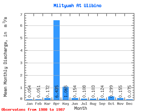
| Statistic | Jan | Feb | Mar | Apr | May | Jun | Jul | Aug | Sep | Oct | Nov | Dec | Annual |
|---|---|---|---|---|---|---|---|---|---|---|---|---|---|
| Mean | 0.05 | 0.05 | 0.17 | 6.43 | 1.06 | 0.15 | 0.11 | 0.10 | 0.12 | 0.30 | 0.15 | 0.07 | 0.74 |
| Standard Deviation | 0.02 | 0.03 | 0.22 | 2.16 | 0.74 | 0.12 | 0.08 | 0.04 | 0.14 | 0.16 | 0.09 | 0.05 | 0.25 |
| Min | 0.03 | 0.01 | 0.02 | 3.68 | 0.12 | 0.03 | 0.04 | 0.03 | 0.04 | 0.14 | 0.05 | 0.02 | 0.40 |
| Max | 0.08 | 0.10 | 0.66 | 9.70 | 2.19 | 0.33 | 0.25 | 0.17 | 0.47 | 0.64 | 0.31 | 0.17 | 1.04 |
| Coefficient of Variation | 0.40 | 0.57 | 1.27 | 0.34 | 0.69 | 0.81 | 0.76 | 0.44 | 1.16 | 0.54 | 0.57 | 0.68 | 0.33 |
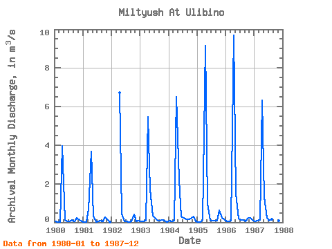
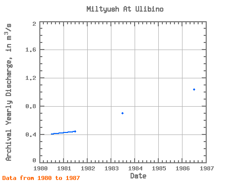
| Year | Jan | Feb | Mar | Apr | May | Jun | Jul | Aug | Sep | Oct | Nov | Dec | Annual | 1980 | 0.04 | 0.01 | 0.02 | 3.96 | 0.12 | 0.04 | 0.06 | 0.11 | 0.06 | 0.25 | 0.14 | 0.04 | 0.40 | 1981 | 0.03 | 0.03 | 0.66 | 3.68 | 0.29 | 0.03 | 0.04 | 0.07 | 0.04 | 0.28 | 0.14 | 0.02 | 0.44 | 1982 | 6.72 | 0.44 | 0.04 | 0.04 | 0.03 | 0.06 | 0.43 | 0.05 | 0.09 | 1983 | 0.06 | 0.07 | 0.09 | 5.46 | 1.70 | 0.33 | 0.25 | 0.09 | 0.07 | 0.14 | 0.08 | 0.03 | 0.70 | 1984 | 0.08 | 0.05 | 0.10 | 6.51 | 2.19 | 0.31 | 0.22 | 0.17 | 0.15 | 0.19 | 0.31 | 0.07 | 0.86 | 1985 | 0.03 | 0.04 | 0.14 | 9.14 | 0.97 | 0.08 | 0.08 | 0.08 | 0.08 | 0.64 | 0.22 | 0.17 | 0.97 | 1986 | 0.07 | 0.07 | 0.08 | 9.70 | 1.49 | 0.19 | 0.11 | 0.11 | 0.06 | 0.25 | 0.22 | 0.12 | 1.04 | 1987 | 0.07 | 0.10 | 0.12 | 6.31 | 1.32 | 0.22 | 0.07 | 0.16 | 0.47 | 0.21 | 0.08 | 0.06 | 0.77 |
|---|
 Return to R-Arctic Net Home Page