|
|
|||||||||||||||||
| Point ID: 6926 | Downloads | Plots | Site Data | Other Close Sites | Code: 10591 |
|
|
|||||||||||||||||
| Download | |
|---|---|
| Site Descriptor Information | Site Time Series Data |
| Link to all available data | |
|
|
| View: | Statistics | Time Series |
| Units: | mm |
| Statistic | Jan | Feb | Mar | Apr | May | Jun | Jul | Aug | Sep | Oct | Nov | Dec | Annual |
|---|---|---|---|---|---|---|---|---|---|---|---|---|---|
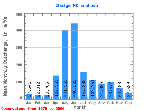
| Mean | 27.64 | 22.31 | 23.70 | 137.35 | 401.35 | 440.22 | 157.28 | 109.96 | 91.35 | 98.57 | 64.19 | 37.53 | 133.12 |
| Standard Deviation | 5.39 | 4.70 | 8.91 | 54.68 | 91.55 | 147.10 | 44.61 | 29.62 | 30.13 | 43.45 | 38.35 | 9.76 | 20.87 |
| Min | 16.80 | 9.60 | 9.59 | 59.60 | 243.00 | 207.00 | 82.40 | 67.30 | 51.20 | 54.20 | 20.90 | 26.50 | 93.43 |
| Max | 35.30 | 28.70 | 47.90 | 262.00 | 592.00 | 765.00 | 239.00 | 161.00 | 143.00 | 213.00 | 189.00 | 59.50 | 170.08 |
| Coefficient of Variation | 0.20 | 0.21 | 0.38 | 0.40 | 0.23 | 0.33 | 0.28 | 0.27 | 0.33 | 0.44 | 0.60 | 0.26 | 0.16 |
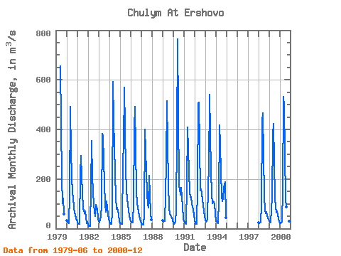
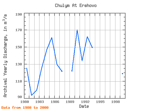
| Year | Jan | Feb | Mar | Apr | May | Jun | Jul | Aug | Sep | Oct | Nov | Dec | Annual | 1979 | 655.00 | 198.00 | 102.00 | 122.00 | 57.80 | 1980 | 33.40 | 26.10 | 22.60 | 137.00 | 491.00 | 305.00 | 136.00 | 131.00 | 82.30 | 65.20 | 42.60 | 33.10 | 125.44 | 1981 | 27.30 | 19.40 | 18.20 | 218.00 | 294.00 | 209.00 | 82.40 | 73.00 | 62.00 | 70.50 | 20.90 | 26.50 | 93.43 | 1982 | 16.80 | 9.60 | 9.59 | 169.00 | 355.00 | 207.00 | 95.70 | 67.30 | 51.20 | 96.30 | 78.20 | 37.70 | 99.45 | 1983 | 30.10 | 25.70 | 47.90 | 92.30 | 382.00 | 371.00 | 183.00 | 95.70 | 67.00 | 110.00 | 58.50 | 38.70 | 125.16 | 1984 | 29.80 | 22.90 | 18.00 | 66.20 | 592.00 | 436.00 | 224.00 | 126.00 | 79.40 | 85.00 | 57.80 | 27.70 | 147.07 | 1985 | 22.50 | 21.90 | 17.30 | 262.00 | 343.00 | 569.00 | 239.00 | 153.00 | 119.00 | 95.40 | 52.30 | 37.60 | 161.00 | 1986 | 29.50 | 23.90 | 24.10 | 106.00 | 403.00 | 492.00 | 154.00 | 99.50 | 88.80 | 67.20 | 40.00 | 27.40 | 129.62 | 1987 | 20.50 | 16.30 | 15.10 | 59.60 | 399.00 | 314.00 | 143.00 | 97.00 | 85.90 | 213.00 | 60.70 | 36.20 | 121.69 | 1989 | 32.20 | 27.70 | 30.80 | 136.00 | 272.00 | 516.00 | 179.00 | 85.20 | 57.70 | 54.20 | 41.00 | 34.50 | 122.19 | 1990 | 21.50 | 18.00 | 26.90 | 75.70 | 376.00 | 765.00 | 168.00 | 161.00 | 136.00 | 165.00 | 89.50 | 38.40 | 170.08 | 1991 | 29.90 | 23.60 | 19.40 | 177.00 | 408.00 | 317.00 | 145.00 | 128.00 | 129.00 | 101.00 | 75.70 | 54.60 | 134.02 | 1992 | 33.90 | 20.90 | 17.90 | 168.00 | 506.00 | 509.00 | 154.00 | 158.00 | 143.00 | 115.00 | 72.40 | 48.40 | 162.21 | 1993 | 35.30 | 26.30 | 36.90 | 177.00 | 243.00 | 540.00 | 230.00 | 138.00 | 102.00 | 111.00 | 97.80 | 59.50 | 149.73 | 1994 | 31.30 | 28.70 | 22.20 | 115.00 | 417.00 | 337.00 | 129.00 | 110.00 | 123.00 | 165.00 | 189.00 | 44.30 | 142.62 | 1998 | 24.10 | 20.60 | 23.10 | 93.20 | 432.00 | 467.00 | 131.00 | 76.80 | 62.20 | 66.80 | 41.00 | 39.70 | 123.12 | 1999 | 29.70 | 24.90 | 25.50 | 129.00 | 378.00 | 422.00 | 121.00 | 91.10 | 63.30 | 71.00 | 42.80 | 26.80 | 118.76 | 2000 | 22.10 | 22.80 | 27.50 | 154.00 | 532.00 | 493.00 | 119.00 | 86.70 | 70.50 | 64.90 | 31.00 | 26.90 | 137.53 |
|---|
| Other Close Sites | ||||||
|---|---|---|---|---|---|---|
| PointID | Latitude | Longitude | Drainage Area | Source | Name | |
| 6790 | "Chulym At Krasny Zavod" | 56.17 | -4530 | SHI | 1180.00 | |
 Return to R-Arctic Net Home Page