|
|
|||||||||||||||||
| Point ID: 6910 | Downloads | Plots | Site Data | Code: 10571 |
|
|
|||||||||||||||||
| Download | |
|---|---|
| Site Descriptor Information | Site Time Series Data |
| Link to all available data | |
|
|
| View: | Statistics | Time Series |
| Units: | mm |
| Statistic | Jan | Feb | Mar | Apr | May | Jun | Jul | Aug | Sep | Oct | Nov | Dec | Annual |
|---|---|---|---|---|---|---|---|---|---|---|---|---|---|
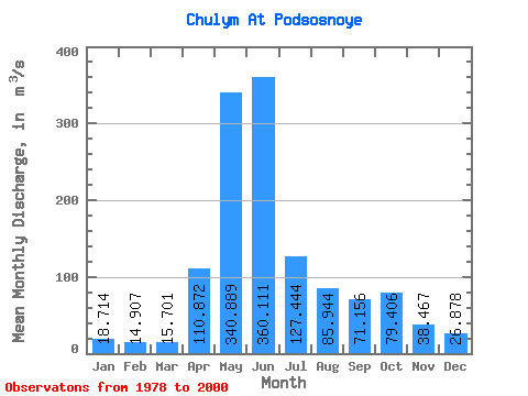
| Mean | 18.71 | 14.91 | 15.70 | 110.87 | 340.89 | 360.11 | 127.44 | 85.94 | 71.16 | 79.41 | 38.47 | 26.88 | 107.54 |
| Standard Deviation | 5.47 | 4.08 | 3.85 | 67.39 | 55.14 | 110.02 | 34.98 | 23.98 | 24.20 | 35.43 | 13.59 | 9.05 | 15.35 |
| Min | 9.67 | 9.02 | 9.31 | 49.60 | 213.00 | 160.00 | 57.70 | 49.00 | 39.40 | 44.90 | 19.20 | 13.60 | 74.03 |
| Max | 30.60 | 22.40 | 25.40 | 350.00 | 420.00 | 534.00 | 189.00 | 134.00 | 123.00 | 174.00 | 64.20 | 52.80 | 129.74 |
| Coefficient of Variation | 0.29 | 0.27 | 0.24 | 0.61 | 0.16 | 0.31 | 0.27 | 0.28 | 0.34 | 0.45 | 0.35 | 0.34 | 0.14 |
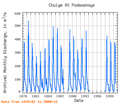
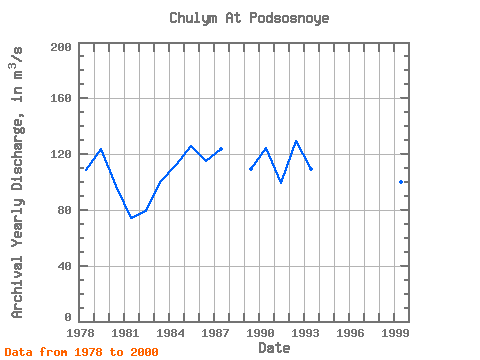
| Year | Jan | Feb | Mar | Apr | May | Jun | Jul | Aug | Sep | Oct | Nov | Dec | Annual | 1978 | 22.80 | 15.20 | 19.30 | 117.00 | 374.00 | 375.00 | 116.00 | 84.90 | 70.90 | 57.40 | 33.00 | 13.60 | 108.26 | 1979 | 10.40 | 11.00 | 13.70 | 62.40 | 318.00 | 534.00 | 189.00 | 78.70 | 110.00 | 68.40 | 56.30 | 30.40 | 123.53 | 1980 | 20.30 | 11.70 | 14.10 | 122.00 | 368.00 | 237.00 | 115.00 | 111.00 | 63.70 | 47.80 | 31.50 | 21.00 | 96.92 | 1981 | 14.70 | 11.30 | 13.30 | 162.00 | 273.00 | 173.00 | 57.70 | 49.00 | 46.10 | 50.70 | 20.20 | 17.30 | 74.03 | 1982 | 10.90 | 9.11 | 9.31 | 106.00 | 306.00 | 160.00 | 79.20 | 49.30 | 39.40 | 99.80 | 53.30 | 29.40 | 79.31 | 1983 | 19.90 | 15.70 | 15.40 | 49.60 | 305.00 | 334.00 | 138.00 | 78.60 | 55.60 | 110.00 | 54.10 | 33.40 | 100.78 | 1984 | 21.90 | 15.70 | 15.00 | 68.90 | 397.00 | 378.00 | 166.00 | 89.10 | 51.80 | 66.10 | 44.10 | 29.00 | 111.88 | 1985 | 21.00 | 18.50 | 14.60 | 117.00 | 310.00 | 494.00 | 182.00 | 126.00 | 89.40 | 70.90 | 36.50 | 31.00 | 125.91 | 1986 | 18.80 | 15.30 | 14.90 | 64.70 | 405.00 | 482.00 | 126.00 | 79.40 | 68.20 | 51.50 | 29.50 | 22.80 | 114.84 | 1987 | 15.00 | 12.90 | 12.30 | 350.00 | 317.00 | 277.00 | 117.00 | 63.20 | 71.80 | 174.00 | 44.80 | 27.90 | 123.58 | 1989 | 24.30 | 20.10 | 22.60 | 97.70 | 286.00 | 470.00 | 156.00 | 78.50 | 49.20 | 44.90 | 36.50 | 29.00 | 109.57 | 1990 | 19.70 | 13.50 | 14.00 | 54.10 | 420.00 | 366.00 | 134.00 | 134.00 | 105.00 | 150.00 | 50.60 | 32.60 | 124.46 | 1991 | 23.40 | 19.50 | 15.80 | 88.40 | 319.00 | 231.00 | 107.00 | 94.00 | 98.40 | 74.00 | 64.20 | 52.80 | 98.96 | 1992 | 30.60 | 22.10 | 20.70 | 153.00 | 403.00 | 390.00 | 124.00 | 119.00 | 123.00 | 97.10 | 42.40 | 32.00 | 129.74 | 1993 | 24.60 | 22.40 | 25.40 | 103.00 | 213.00 | 461.00 | 172.00 | 90.10 | 69.70 | 83.00 | 32.00 | 15.70 | 109.33 | 1994 | 16.80 | 15.40 | 16.50 | 1998 | 13.70 | 11.00 | 15.70 | 107.00 | 363.00 | 425.00 | 105.00 | 64.00 | 58.20 | 66.00 | 19.20 | 27.90 | 106.31 | 1999 | 17.10 | 13.80 | 12.60 | 75.60 | 381.00 | 352.00 | 111.00 | 83.70 | 49.80 | 62.30 | 24.40 | 20.10 | 100.28 | 2000 | 9.67 | 9.02 | 13.10 | 97.30 | 378.00 | 343.00 | 99.10 | 74.50 | 60.60 | 55.40 | 19.80 | 17.90 | 98.12 |
|---|
 Return to R-Arctic Net Home Page