|
|
|||||||||||||||||
| Point ID: 6872 | Downloads | Plots | Site Data | Code: 10498 |
|
|
|||||||||||||||||
| Download | |
|---|---|
| Site Descriptor Information | Site Time Series Data |
| Link to all available data | |
|
|
| View: | Statistics | Time Series |
| Units: | mm |
| Statistic | Jan | Feb | Mar | Apr | May | Jun | Jul | Aug | Sep | Oct | Nov | Dec | Annual |
|---|---|---|---|---|---|---|---|---|---|---|---|---|---|
| Mean | 47.68 | 36.91 | 31.81 | 35.11 | 200.90 | 361.97 | 163.44 | 110.90 | 117.05 | 125.72 | 84.73 | 65.88 | 112.67 |
| Standard Deviation | 14.98 | 10.25 | 7.48 | 10.72 | 103.23 | 121.44 | 53.65 | 35.20 | 44.21 | 58.97 | 32.72 | 28.40 | 22.32 |
| Min | 26.30 | 20.40 | 18.60 | 16.70 | 33.10 | 129.00 | 85.00 | 50.60 | 56.80 | 49.50 | 28.30 | 28.10 | 76.28 |
| Max | 87.70 | 62.60 | 47.20 | 61.30 | 413.00 | 573.00 | 279.00 | 197.00 | 201.00 | 247.00 | 155.00 | 142.00 | 141.19 |
| Coefficient of Variation | 0.31 | 0.28 | 0.23 | 0.30 | 0.51 | 0.34 | 0.33 | 0.32 | 0.38 | 0.47 | 0.39 | 0.43 | 0.20 |
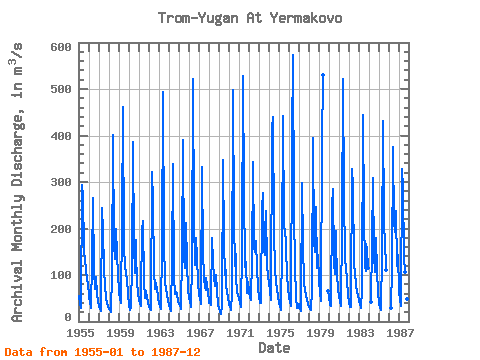
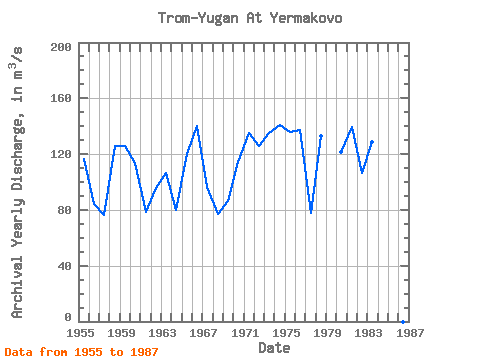
| Year | Jan | Feb | Mar | Apr | May | Jun | Jul | Aug | Sep | Oct | Nov | Dec | Annual | 1955 | 54.70 | 38.90 | 28.80 | 33.40 | 294.00 | 267.00 | 158.00 | 123.00 | 120.00 | 111.00 | 89.80 | 82.10 | 116.72 | 1956 | 55.70 | 38.50 | 34.00 | 29.40 | 131.00 | 265.00 | 109.00 | 68.90 | 78.70 | 96.40 | 58.30 | 42.10 | 83.92 | 1957 | 33.00 | 27.50 | 23.60 | 23.80 | 244.00 | 194.00 | 116.00 | 72.30 | 56.80 | 51.40 | 40.80 | 32.10 | 76.28 | 1958 | 26.30 | 24.80 | 22.40 | 20.10 | 103.00 | 401.00 | 166.00 | 134.00 | 163.00 | 200.00 | 143.00 | 103.00 | 125.55 | 1959 | 63.70 | 48.40 | 42.60 | 39.00 | 219.00 | 462.00 | 159.00 | 121.00 | 102.00 | 102.00 | 91.70 | 58.90 | 125.78 | 1960 | 33.40 | 25.30 | 30.00 | 34.30 | 119.00 | 386.00 | 164.00 | 105.00 | 176.00 | 146.00 | 85.10 | 58.50 | 113.55 | 1961 | 45.60 | 37.70 | 32.90 | 61.30 | 196.00 | 217.00 | 85.00 | 50.60 | 64.80 | 64.30 | 51.90 | 39.10 | 78.85 | 1962 | 30.40 | 26.70 | 25.20 | 32.70 | 321.00 | 257.00 | 109.00 | 69.30 | 82.90 | 69.50 | 74.40 | 50.10 | 95.68 | 1963 | 38.60 | 33.10 | 27.00 | 29.70 | 159.00 | 494.00 | 172.00 | 84.70 | 68.30 | 67.30 | 58.10 | 44.20 | 106.33 | 1964 | 35.10 | 27.10 | 23.10 | 23.00 | 132.00 | 339.00 | 95.00 | 60.10 | 60.40 | 63.00 | 58.40 | 42.70 | 79.91 | 1965 | 38.50 | 33.00 | 28.90 | 27.90 | 148.00 | 390.00 | 139.00 | 115.00 | 121.00 | 212.00 | 125.00 | 65.10 | 120.28 | 1966 | 53.50 | 39.40 | 36.40 | 31.50 | 129.00 | 521.00 | 216.00 | 122.00 | 130.00 | 179.00 | 139.00 | 83.80 | 140.05 | 1967 | 57.90 | 51.00 | 38.20 | 58.20 | 332.00 | 149.00 | 94.60 | 73.60 | 67.00 | 92.60 | 75.80 | 64.80 | 96.22 | 1968 | 40.50 | 39.20 | 35.10 | 40.90 | 180.00 | 129.00 | 96.60 | 75.30 | 84.00 | 101.00 | 67.60 | 35.90 | 77.09 | 1969 | 28.40 | 20.40 | 18.60 | 16.70 | 33.10 | 347.00 | 172.00 | 99.50 | 110.00 | 79.80 | 61.00 | 53.50 | 86.67 | 1970 | 38.70 | 30.30 | 28.30 | 25.40 | 59.90 | 497.00 | 215.00 | 119.00 | 146.00 | 94.40 | 64.10 | 56.30 | 114.53 | 1971 | 50.40 | 39.50 | 34.10 | 30.50 | 154.00 | 527.00 | 279.00 | 122.00 | 111.00 | 128.00 | 60.30 | 83.90 | 134.97 | 1972 | 63.90 | 50.50 | 47.20 | 54.20 | 130.00 | 343.00 | 159.00 | 150.00 | 156.00 | 173.00 | 114.00 | 71.00 | 125.98 | 1973 | 53.00 | 39.40 | 39.30 | 51.30 | 242.00 | 276.00 | 152.00 | 142.00 | 171.00 | 237.00 | 123.00 | 94.10 | 135.01 | 1974 | 84.60 | 62.60 | 46.50 | 45.30 | 413.00 | 440.00 | 194.00 | 111.00 | 87.80 | 84.20 | 70.50 | 54.80 | 141.19 | 1975 | 40.70 | 32.50 | 24.70 | 30.80 | 153.00 | 443.00 | 208.00 | 191.00 | 176.00 | 161.00 | 98.80 | 71.80 | 135.94 | 1976 | 52.60 | 39.90 | 35.30 | 33.20 | 389.00 | 573.00 | 248.00 | 104.00 | 67.70 | 49.50 | 28.30 | 28.10 | 137.38 | 1977 | 37.70 | 27.30 | 23.60 | 35.30 | 297.00 | 160.00 | 87.80 | 63.60 | 59.60 | 54.20 | 48.70 | 36.30 | 77.59 | 1978 | 31.30 | 27.50 | 24.70 | 24.40 | 68.60 | 395.00 | 173.00 | 150.00 | 201.00 | 247.00 | 115.00 | 142.00 | 133.29 | 1979 | 87.70 | 61.20 | 46.00 | 43.30 | 379.00 | 530.00 | 65.60 | 1980 | 55.20 | 36.10 | 33.40 | 37.30 | 246.00 | 284.00 | 126.00 | 103.00 | 195.00 | 169.00 | 102.00 | 69.10 | 121.34 | 1981 | 52.90 | 44.30 | 33.90 | 35.20 | 204.00 | 521.00 | 269.00 | 137.00 | 111.00 | 118.00 | 88.50 | 56.20 | 139.25 | 1982 | 42.90 | 31.00 | 30.60 | 48.00 | 329.00 | 291.00 | 126.00 | 103.00 | 80.60 | 75.40 | 62.80 | 57.20 | 106.46 | 1983 | 44.20 | 38.30 | 29.90 | 30.50 | 66.00 | 444.00 | 228.00 | 119.00 | 109.00 | 166.00 | 155.00 | 114.00 | 128.66 | 1984 | 43.00 | 167.00 | 308.00 | 141.00 | 106.00 | 150.00 | 180.00 | 107.00 | 64.20 | 1985 | 40.60 | 28.10 | 25.20 | 25.80 | 148.00 | 432.00 | 226.00 | 150.00 | 138.00 | 110.00 | 1986 | 28.70 | 115.00 | 376.00 | 210.00 | 197.00 | 187.00 | 237.00 | 120.00 | 142.00 | 1987 | 66.30 | 44.60 | 36.70 | 34.40 | 329.00 | 287.00 | 137.00 | 107.00 | 114.00 | 104.00 | 48.60 | 45.60 | 112.85 |
|---|
 Return to R-Arctic Net Home Page
