|
|
|||||||||||||||||
| Point ID: 6861 | Downloads | Plots | Site Data | Code: 10479 |
|
|
|||||||||||||||||
| Download | |
|---|---|
| Site Descriptor Information | Site Time Series Data |
| Link to all available data | |
|
|
| View: | Statistics | Time Series |
| Units: | mm |
| Statistic | Jan | Feb | Mar | Apr | May | Jun | Jul | Aug | Sep | Oct | Nov | Dec | Annual |
|---|---|---|---|---|---|---|---|---|---|---|---|---|---|
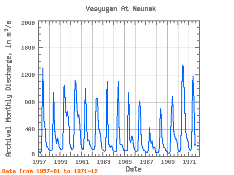
| Mean | 92.01 | 81.61 | 74.94 | 121.83 | 795.40 | 950.67 | 615.67 | 351.20 | 283.47 | 248.05 | 192.62 | 124.22 | 327.64 |
| Standard Deviation | 25.38 | 18.23 | 17.81 | 59.87 | 181.34 | 276.77 | 334.57 | 227.83 | 176.91 | 157.75 | 103.15 | 48.94 | 101.94 |
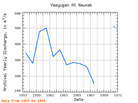
| Min | 56.50 | 50.10 | 45.70 | 67.10 | 420.00 | 260.00 | 191.00 | 146.00 | 119.00 | 94.80 | 88.00 | 64.30 | 155.97 |
| Max | 135.00 | 110.00 | 97.70 | 311.00 | 1060.00 | 1340.00 | 1320.00 | 917.00 | 658.00 | 615.00 | 433.00 | 210.00 | 507.57 |
| Coefficient of Variation | 0.28 | 0.22 | 0.24 | 0.49 | 0.23 | 0.29 | 0.54 | 0.65 | 0.62 | 0.64 | 0.54 | 0.39 | 0.31 |
| Year | Jan | Feb | Mar | Apr | May | Jun | Jul | Aug | Sep | Oct | Nov | Dec | Annual | 1957 | 74.10 | 60.90 | 45.70 | 76.00 | 954.00 | 1300.00 | 528.00 | 477.00 | 227.00 | 137.00 | 137.00 | 101.00 | 343.14 | 1958 | 90.50 | 87.10 | 84.30 | 93.30 | 595.00 | 942.00 | 390.00 | 275.00 | 189.00 | 267.00 | 210.00 | 140.00 | 280.27 | 1959 | 120.00 | 97.70 | 96.50 | 124.00 | 1010.00 | 1040.00 | 810.00 | 589.00 | 658.00 | 580.00 | 396.00 | 197.00 | 476.52 | 1960 | 130.00 | 107.00 | 95.10 | 131.00 | 850.00 | 1120.00 | 1060.00 | 686.00 | 580.00 | 615.00 | 433.00 | 210.00 | 501.43 | 1961 | 135.00 | 110.00 | 97.70 | 311.00 | 1000.00 | 897.00 | 402.00 | 227.00 | 238.00 | 180.00 | 145.00 | 108.00 | 320.89 | 1962 | 96.90 | 98.70 | 95.70 | 155.00 | 825.00 | 854.00 | 854.00 | 417.00 | 380.00 | 317.00 | 178.00 | 111.00 | 365.19 | 1963 | 97.00 | 83.40 | 73.90 | 83.30 | 875.00 | 1100.00 | 254.00 | 146.00 | 135.00 | 153.00 | 143.00 | 95.60 | 269.93 | 1964 | 79.80 | 77.80 | 73.20 | 77.50 | 762.00 | 1100.00 | 495.00 | 180.00 | 178.00 | 173.00 | 131.00 | 91.80 | 284.93 | 1965 | 73.30 | 79.90 | 80.80 | 92.80 | 784.00 | 936.00 | 249.00 | 203.00 | 296.00 | 272.00 | 152.00 | 99.00 | 276.48 | 1966 | 81.70 | 78.10 | 74.40 | 79.40 | 672.00 | 811.00 | 712.00 | 188.00 | 142.00 | 94.80 | 88.30 | 78.80 | 258.38 | 1967 | 64.00 | 58.80 | 55.50 | 155.00 | 420.00 | 260.00 | 191.00 | 224.00 | 119.00 | 136.00 | 124.00 | 64.30 | 155.97 | 1968 | 56.50 | 61.50 | 53.40 | 128.00 | 699.00 | 590.00 | 295.00 | 187.00 | 131.00 | 130.00 | 88.00 | 76.80 | 208.02 | 1969 | 62.20 | 50.10 | 47.70 | 67.10 | 560.00 | 790.00 | 883.00 | 381.00 | 302.00 | 256.00 | 252.00 | 173.00 | 318.68 | 1970 | 95.10 | 76.80 | 69.90 | 124.00 | 865.00 | 1340.00 | 1320.00 | 917.00 | 534.00 | 284.00 | 259.00 | 206.00 | 507.57 | 1971 | 124.00 | 96.40 | 80.30 | 130.00 | 1060.00 | 1180.00 | 792.00 | 171.00 | 143.00 | 126.00 | 153.00 | 111.00 | 347.23 |
|---|
 Return to R-Arctic Net Home Page
